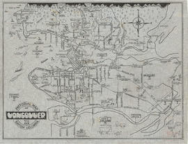
Perspective of Greater Vancouver from Grouse Mountain (elevation 4000 ft.)
- AM1594-: MAP 566
- Item
- [ca. 1925]
Part of City of Vancouver Archives technical and cartographic drawing collection
item is an illustrated, map-like pictorial view of Greater Vancouver. Locations of districts, waterways, beaches, golf courses, principal parks and significant buildings are identified by matching an index list to corresponding letters and numbers on the vertical and horizontal axes along the border of the map.