
Ceremony in Queen Elizabeth Park
- AM1187-: CVA 1187-122
- Item
- Jul. 21, 1954
Part of Artona Studios fonds
Item is a photograph showing a man at a microphone, a flag draped on a rock, with crowd looking on.
Ceremony in Queen Elizabeth Park
Part of Artona Studios fonds
Item is a photograph showing a man at a microphone, a flag draped on a rock, with crowd looking on.
![Q[ueen] E[lizabeth] Park](/uploads/r/null/4/8/4/484dd62a03a61c8beed91015360c801177c1f5f33080da3bbceb3b3565fbc3be/218680c1-9c10-4552-9988-8eae7235ae50-CVA1187-123_142.jpg)
Part of Artona Studios fonds
![Q[ueen] E[lizabeth] Park](/uploads/r/null/d/2/4/d24607670387bf5976b0b933e33df9822fc6db6fade75837c01b08a09cc56a7a/422c3e71-9c9a-4bb5-8675-a6c6661b5475-CVA1187-124_142.jpg)
Part of Artona Studios fonds

Bridge in Queen Elizabeth Park
Part of Artona Studios fonds

Queen Elizabeth Park at the end of construction
Part of Artona Studios fonds

Part of Artona Studios fonds

Part of Artona Studios fonds

Bridge in Queen Elizabeth Park
Part of Artona Studios fonds

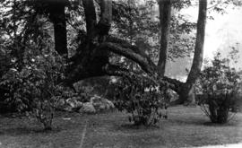
Twisted trunks of maple trees in Stanley Park with house and garden beyond
Part of Samuel H. Logan fonds

Trees and walkway overlooking Coal Harbour in Stanley Park
Part of Samuel H. Logan fonds

Brockton Point, Stanley Park from water
Part of Samuel H. Logan fonds
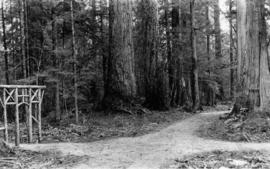
Forest walk and ornamental gateway of cedar logs in Stanley Park
Part of Samuel H. Logan fonds

Grove of cedars and firs, Stanley Park
Part of Samuel H. Logan fonds

Pathways in Stanley Park looking north
Part of Samuel H. Logan fonds

Duck pond and fountain in the snow, Stanley Park
Part of Samuel H. Logan fonds

Duck pond with Lumberman's Arch in distance, Stanley Park
Part of Samuel H. Logan fonds
Cleared area with shrubs around maple trees in Stanley Park
Part of Samuel H. Logan fonds

Sheet N : Musqueam Reserve to Wallace Street and Thirty-eighth Avenue to Forty-ninth Avenue
Part of City of Vancouver Archives technical and cartographic drawing collection
Item is a section showing the area from the Musqueam Reserve to Wallace Street and Thirty-eighth Avenue to Forty-ninth Avenue. Includes streets, roads and sewers; blocks, lots and legal descriptions; and parks and schools.
Vancouver (B.C.). Office of the City Engineer

Sheet O : Holland Street to Elm Street and Thirty-eighth Avenue to Forty-ninth Avenue
Part of City of Vancouver Archives technical and cartographic drawing collection
Item is a section showing the area from Holland Street to Elm Street and Thirty-eighth Avenue to Forty-ninth Avenue. Includes streets, roads and sewers; blocks, lots and legal descriptions; and golf courses, parks and schools.
Vancouver (B.C.). Office of the City Engineer

Sheet P : Trafalgar Street to Granville Street and Thirty-ninth Avenue to Thirty-seventh Street
Part of City of Vancouver Archives technical and cartographic drawing collection
Item is a section showing the area from Trafalgar Street to Granville Street and Thirty-ninth Avenue to Thirty-seventh Street. Includes streets and roads; blocks, lots and legal descriptions; and parks and schools.
Vancouver (B.C.). Office of the City Engineer

Sheet T : Marine Crescent to Granville Street and Forty-ninth Avenue to Sixty-first Avenue
Part of City of Vancouver Archives technical and cartographic drawing collection
Item is a section showing the area from Marine Crescent to Granville Street and Forty-ninth Avenue to Sixty-first Avenue. Includes streets and roads; blocks, lots and legal descriptions; and parks and golf courses.
Vancouver (B.C.). Office of the City Engineer

Sheet U : Churchill Street to Cambie Street and Forty-ninth Avenue to Park Drive
Part of City of Vancouver Archives technical and cartographic drawing collection
Item is a section showing the area from Churchill Street to Cambie Street and Forty-ninth Avenue to Park Drive. Includes streets and roads; blocks, lots and legal descriptions; and parks and golf courses.
Vancouver (B.C.). Office of the City Engineer

Sheet W : Fraser River to French Street and Fifty-ninth Avenue to Seventy-first Avenue
Part of City of Vancouver Archives technical and cartographic drawing collection
Item is a section showing the area from Fraser River to French Street and Fifty-ninth Avenue to Seventy-first Avenue. Includes streets and roads; blocks, lots and legal descriptions; and parks and golf courses.
Vancouver (B.C.). Office of the City Engineer

Sheet X : Marine Drive to Ash Street and Fifty-ninth Avenue to Seventy-first Avenue
Part of City of Vancouver Archives technical and cartographic drawing collection
Item is a section showing the area from Marine Drive to Ash Street and Fifty-ninth Avenue to Seventy-first Avenue. Includes streets and roads; blocks, lots and legal descriptions; and parks and schools.
Vancouver (B.C.). Office of the City Engineer

Sheet 1 : Cambie Street to Carolina Street and Sixteenth Avenue to Twenty-eighth Avenue
Part of City of Vancouver Archives technical and cartographic drawing collection
Item is a section showing the area from Cambie Street to Carolina Street and Sixteenth Avenue to Twenty-eighth Avenue. Includes streets, roads, blocks, lots, legal descriptions, parks, nurseries and schools.
Vancouver (B.C.). Office of the City Engineer

Sheet S.V. 3 : Cambie Street to St. George Street and Twenty-seventh Avenue to Thirty-eighth Avenue
Part of City of Vancouver Archives technical and cartographic drawing collection
Item is a section showing the area from Cambie Street to St. George Street and Twenty-seventh Avenue to Thirty-eighth Avenue. Map shows streets, roads, blocks, lots and legal descriptions and the locations of parks, schools, reservoirs and Mountainview Cemetery.
Vancouver (B.C.). Office of the City Engineer

Sheet 4 : Prince Edward Street to Bruce Street and King Edward Avenue to Thirty-sixth Avenue
Part of City of Vancouver Archives technical and cartographic drawing collection
Item is a section showing the area from Prince Edward Street to Bruce Street and King Edward Avenue to Thirty-sixth Avenue. Map shows streets, roads, blocks, lots and legal descriptions, and the locations of parks, schools and Mountainview Cemetery.
Vancouver (B.C.). Office of the City Engineer

Sheet 5 : Dumfries Street to Fairmont Street and Twenty-seventh Avenue to Thirty-seventh Avenue
Part of City of Vancouver Archives technical and cartographic drawing collection
Item is a section showing the area from Dumfries Street to Fairmont Street and Twenty-seventh Avenue to Thirty-seventh Avenue. Includes streets, roads, blocks, lots, legal descriptions, parks, railway lines and schools.
Vancouver (B.C.). Office of the City Engineer

Sheet 6 : Craddock Street to Boundary Road and Twenty-ninth Avenue to Fortieth Avenue
Part of City of Vancouver Archives technical and cartographic drawing collection
Item is a section showing the area from Craddock Street to Boundary Road and Twenty-ninth Avenue to Fortieth Avenue. Includes streets, roads, blocks, lots, legal descriptions, parks. railway lines and schools.
Vancouver (B.C.). Office of the City Engineer

Sheet 7 : Cambie Street to St. George Street and Thirty-seventh Avenue to Forty-eighth Avenue
Part of City of Vancouver Archives technical and cartographic drawing collection
Item is a section showing the area from Cambie Street to St. George Street and Thirty-seventh Avenue to Forty-eighth Avenue. Includes streets, roads, blocks, lots, legal descriptions, parks, cemeteries, and schools.
Vancouver (B.C.). Office of the City Engineer

Sheet 8 : Prince Edward Street to Bruce Street and Thirty-fifth Avenue to Forty-seventh Avenue
Part of City of Vancouver Archives technical and cartographic drawing collection
Item is a section showing the area from Prince Edward Street to Bruce Street and Thirty-fifth Avenue to Forty-seventh Avenue. Includes streets, roads, blocks, lots, legal descriptions, and cemeteries, parks and schools.
Vancouver (B.C.). Office of the City Engineer

Sheet 9 : Fleming Street to Carlton Street and Thirty-seventh Avenue to Forty-eighth Avenue
Part of City of Vancouver Archives technical and cartographic drawing collection
Item is a section showing the area from Fleming Street to Carlton Street and Thirty-seventh Avenue to Forty-eighth Avenue. Includes streets, roads, blocks, lots, legal descriptions, parks and schools.
Vancouver (B.C.). Office of the City Engineer

Sheet 12 : Prince Edward Street to Bruce Street and Forty-seventh Avenue to Fifty-eighth Avenue
Part of City of Vancouver Archives technical and cartographic drawing collection
Item is a section showing the area from Prince Edward Street to Bruce Street and Forty-seventh Avenue to Fifty-eighth Avenue. Includes streets, roads, blocks, lots, legal descriptions, parks and schools.
Vancouver (B.C.). Office of the City Engineer

Sheet 13 : Fleming Street to Carlton Street and Forty-seventh Avenue to Fifty-ninth Avenue
Part of City of Vancouver Archives technical and cartographic drawing collection
Item is a section showing the area from Fleming Street to Carlton Street and Forty-seventh Avenue to Fifty-ninth Avenue. Includes streets, roads, blocks, lots, legal descriptions, parks and schools.
Vancouver (B.C.). Office of the City Engineer

Sheet 14 : Ash Street to St. George Street and Marine Drive to Fraser River
Part of City of Vancouver Archives technical and cartographic drawing collection
Item is a section showing the area from Ash Street to St. George Street and Marine Drive to Fraser River. Includes streets, roads, blocks, lots, legal descriptions, parks and railway lines.
Vancouver (B.C.). Office of the City Engineer

Sheet 15 : Ash Street to St. George Street and Fifty-eighth Avenue to Marine Drive
Part of City of Vancouver Archives technical and cartographic drawing collection
Item is a section showing the area from Ash Street to St. George Street and Fifty-eighth Avenue to Marine Drive.Includes streets, roads, blocks, lots, legal descriptions, parks and railway lines.
Vancouver (B.C.). Office of the City Engineer

Sheet 16 : St. George Street to Argyle Street and Fifty-eighth Avenue to Fraser River
Part of City of Vancouver Archives technical and cartographic drawing collection
Item is a section showing the area from St. George Street to Argyle Street and Fifty-eighth Avenue to the Fraser River. Includes streets, roads, blocks, lots, legal descriptions, railway lines, parks and schools.
Vancouver (B.C.). Office of the City Engineer

Sheet 17 : Argyle Street to Vivian Street and Sixty-second Avenue to Kent Street
Part of City of Vancouver Archives technical and cartographic drawing collection
Item is a section showing the area from Argyle Street to Vivian Street and Sixty-second Avenue to Kent Street. Includes streets, roads, blocks, lots, legal descriptions and golf courses.
Vancouver (B.C.). Office of the City Engineer

Sheet 18 : Vivian Street to Boundary Road and Sixty-fifth Avenue to Fraser River
Part of City of Vancouver Archives technical and cartographic drawing collection
Item is a section showing the area from Vivian Street to Boundary Road and Sixty-fifth Avenue to Fraser River. Includes streets, roads and railway lines; blocks, lots and legal descriptions; and parks, schools and golf courses.
Vancouver (B.C.). Office of the City Engineer

Sheet A : University Endowment Lands to Imperial Street and waterfront to Fifth Avenue
Part of City of Vancouver fonds
Item is a section showing the area from the University Endowment Lands to Imperial Street and waterfront to Fifth Avenue. Includes streets, roads and sewers; blocks, lots and legal descriptions; and parks. Map is annotated to show tax sale property for sale, property with no water, street widening and drainage, replotting, reserved land for schools, reserved land for parks, sundry land, capital assets not including schools and parks, schools, and parks, as applicable.
Vancouver (B.C.). Office of the City Engineer
![In Stanley Park [with Queen Victoria fountain]](/uploads/r/null/a/b/6/ab632de049f4462017d29f29cb8fc7af67a4fcfc951e75727ee5d95ea8272c1a/3532518e-d833-4705-9299-54e64efb0776-CVA28-03_142.jpg)
In Stanley Park [with Queen Victoria fountain]
Part of Charles F. Smith fonds
Item is a photograph of women and girls at the Queen Victoria fountain in Stanley Park. Other patrons on benches or walking in the park are visible in the background.

Part of Charles F. Smith fonds

Part of Charles F. Smith fonds

Aerial photo, vertical, Exhibition Park, Vancouver

Evening, Prospect Point, Stanley Park

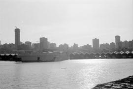
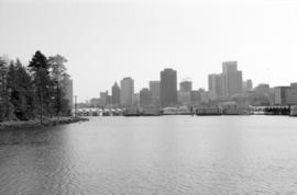
Vancouver skyline and waterfront from Stanley Park seawall
Part of City of Vancouver fonds
Item part is a photograph of the downtown Vancouver skyline and waterfront, looking south across Coal Harbour from the seawall path in Stanley Park. Boat storage units are visible along the coast.
Vancouver skyline and waterfront from Stanley Park seawall
Part of City of Vancouver fonds
Item part is a photograph of the downtown Vancouver skyline and waterfront, looking south across Coal Harbour from the seawall path in Stanley Park. Boat storage units are visible along the coast.
Vancouver skyline and waterfront from Stanley Park seawall
Part of City of Vancouver fonds
Item part is a photograph of the downtown Vancouver skyline and waterfront, looking south across Coal Harbour from the seawall path in Stanley Park. Boat storage units are visible along the coast.
Vancouver skyline and waterfront from Stanley Park seawall
Part of City of Vancouver fonds
Item part is a photograph of the downtown Vancouver skyline and waterfront, looking south across Coal Harbour from the seawall path in Stanley Park. Boat storage units are visible along the coast.

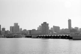
Vancouver skyline and fuel barges from Stanley Park seawall
Part of City of Vancouver fonds
Item part is a photograph of the downtown Vancouver skyline and waterfront, looking south across Coal Harbour from the seawall path in Stanley Park. Several fuel barges (National, Home, and Esso) are visible in the harbour.