Report on the planning and redevelopment of City yards and related buildings
- PUB-: PD 1082
- Item
- 1959
Part of City publications collection
22 results with digital objects Show results with digital objects
Report on the planning and redevelopment of City yards and related buildings
Part of City publications collection
A study of methods for reducing air pollution caused by the operation of motor vehicles
Part of City publications collection
Organization study : zoning and building plan checking sections
Part of City publications collection
Building : whom to see and where to go for help with Engineering Department services
Part of City publications collection
Part of City publications collection
Arrangement and construction of household septic tanks and filters
Part of City publications collection
Evaluation of air pollution in the Lower Mainland
Part of City publications collection
Part of City publications collection
Vancouver telecommunications plan
Part of City publications collection
Part of City publications collection
Annual expenditures by departments : City of Vancouver
Part of City publications collection
The replacement of the City of Vancouver asphalt plant
Part of City publications collection
Report on the downtown parking situation and proposals concerning a parking authority
Part of City publications collection
Part of City publications collection
Snow removal and ice control manual
Part of City publications collection
An information retrieval system for urban areas : technical report
Part of City publications collection
Public works administrative manual
Part of City publications collection
Part of City publications collection
Vancouver transportation study : information for public meeting November 23, 1967
Part of City publications collection
Report includes the following sections: (1) Gore Avenue study report - Parsons, Brinckerhoff, Quade and Douglas; (2) Comparison of Gore Avenue and Carrall Street locations - Parsons, Brinckerhoff, Quade and Douglas; (3) North-south corridors - traffic analysis - Parsons, Brinckerhoff, Quade and Douglas; (4) North-south corridors - other factors - Engineering and Planning Departments; (5) Carrall Street section - architectural treatment - Erickson-Massey; (6) Summary of extra out-of-scope work performed by Parsons, Brinckerhoff, Quade, and Douglas.
Report on False Creek : a report to His Worship the Mayor and Members of the City Council
Part of City publications collection
Overall plan for development of City works yards and related buildings
Part of City publications collection
Report on the environment : for presentation to City Council
Part of City publications collection
Part of City publications collection
Series contains bound organizational charts detailing down to the branch level for the Engineering Department for the years 1975 and 1979-1994 and for Engineering Services for the years 1995-2003. Series also contains a revised single sheet departmental overview chart to be effective Feb. 11, 1991 - July 14, 1991, as well as a memo with a revised departmental overview chart attached dated February 1993.

Part of City publications collection
Part contains a map of the north half of Vancouver (Burrard Inlet to 22nd Avenue) showing bicycle routes, parks, and SkyTrain stations, and textual information on downtown bicycle parking and combining cycling with public transit.

Part of City publications collection
Part contains a map of the south half of Vancouver (22nd Avenue to the Fraser River) showing bicycle routes, parks, and SkyTrain stations, a list of useful contacts for cyclists, and information on bridges and connections.

Part of City publications collection
Part contains a map of Vancouver bicycle routes with a key to attractions, bridges and ferries, and downtown bicycle parking locations. An inset map shows Downtown Vancouver in more detail.

Part of City publications collection
Part contains safety and security information for cyclists and a small map of major bikeways in Vancouver.
Part of City publications collection
Part contains a map of Vancouver bicycle routes with a key to attractions, bridges and ferries, and downtown bicycle parking locations. An inset map shows Downtown Vancouver in more detail.

Part of City publications collection
Part contains safety and security information for cyclists and a small map of major bikeways in Vancouver.

Part of City publications collection


Part of City publications collection

Part of City publications collection

Part of City publications collection

Part of City publications collection

Part of City publications collection

Part of City publications collection

Part of City publications collection

City of Vancouver, B.C. area map : Inverness Street to Boundary Road and 32nd Avenue to 54th Avenue
Part of City publications collection

Part of City publications collection

City of Vancouver, B.C. area map : Maple Street to Heatley Avenue and Burrard Inlet to 6th Avenue
Part of City publications collection
Part of City publications collection
Item is a brochure promoting bicycle use in Vancouver, with a map of bicycle routes on one side and safety information on the other.
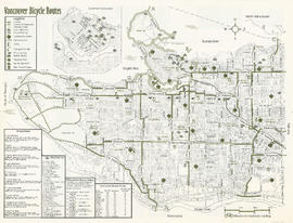
City of Vancouver bicycle route map
Part of City publications collection
Item is a map of Vancouver showing bicycle routes, parks, and SkyTrain stations, and includes a list of contacts for cyclists, information on bridges and connections, and guidance on combining cycling with public transit.
Part of City publications collection
Item is a brochure promoting bicycle use in Vancouver, with a map of bicycle routes on one side and safety information on the other.
City of Vancouver, B.C. area map [sectional map]
Part of City publications collection
Item is a sectional map of Vancouver showing streets, address block numbers, and street codes according to the system adopted by the Engineering Department in the mid-1960s.
Engineering Services : 1999 organization charts
Part of City publications collection