
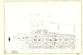
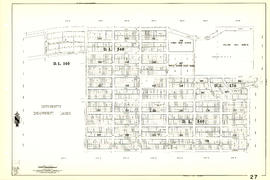
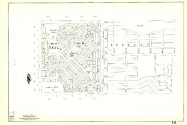
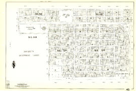
Sheet 18 : Nanaimo Street to Rupert Street and Fifth Avenue to Charles Street
- AM1594-MAP 341-: MAP 341.17
- Item
- [1962?], with revisions to Mar. 1967
Part of City of Vancouver Archives technical and cartographic drawing collection
Item is a section showing the area from Nanaimo Street to Rupert Street and Fifth Avenue to Charles Street. Includes streets, blocks, lots and legal descriptions, and the locations of parks and schools.
Vancouver (B.C.). Engineering Services


![[View across the C.P.R. park towards] Granville Street and Georgia Street](/uploads/r/null/3/9/39f20049e1c57b242c111473809ed9c93039743ea3bd3125af72f80a28b34678/59eb1dac-26fd-46c8-a5c0-0ba5bb8f771e-A26268_142.jpg)
![[Aerial view of Mount Pleasant, South Strathcona and Kensington-Cedar Cottage]](/uploads/r/null/7/5/75ea991fe8319eaffda79b314cbf20e281e35eb2cd8a89eaa898b492242d6282/05f856f3-0a45-41eb-94dc-46cb9d2f7ecf-A63348_142.jpg)
![[Aerial view of Vancouver]](/uploads/r/null/b/9/b973b9a4143a5316b02e728c35d99e383f27a3db21d8e20aa7bbb459780243bc/3ff38b56-6b36-4c17-bce1-329c97459d29-A66598_142.jpg)
![[Aerial view of West Point Grey, Kitsilano, Dunbar - Southlands and University Endowment Lands]](/uploads/r/null/0/8/089d213e9a81ca689130a244122a86972e068c9b01ab994922a88072ac881121/1ed71859-c157-4686-82db-e3483cd4b877-A66599_142.jpg)
![[Aerial view of Burrard Inlet, Hastings-Sunrise, Burnaby and the District of North Vancouver]](/uploads/r/null/d/f/df7e11c97173ce0473c454f0a01569b641972f6efdc12bf192edbc42119542d6/6d72f89b-9b55-48c4-bef6-04eb2137f1d3-A66600_142.jpg)


![City of Vancouver [park sites June/80]](/uploads/r/null/9/4/9484add7c4684ea3838e4d00ee8add3ecf85d78d5aa8fe2780cae273e59556a5/bd2464d8-2aa9-4501-aba6-8b3f7d130a42-MAP1032_142.jpg)


![[View of the Great Northern (Union) and Canadian National Stations and Thornton Park]](/uploads/r/null/3/f/3f3bf794ce9c38103d6e1f740d743b90cf54e8f2591d95f7406a69a338615147/b1609fd1-5aca-4ca5-87bc-b899b4c76130-A63485_142.jpg)


![[Stanley Park, viewed from English Bay]](/uploads/r/null/5/6/568faca829e51723935ed64071e5320eae9857bfd5589ef4d3e1785742ac3b4a/bbcbb422-80e1-4cad-9330-84ae15b2e951-A04002_142.jpg)
![[Boat in Burrard Inlet, near Brockton Point]](/uploads/r/null/0/c/0c2fa95b7dc1fa230d6e1536914f2653429ab4c9d5964b9720c697e3971cdba6/07ce4d85-4bef-42ff-996f-f6a284719e8d-A04014_142.jpg)


![Hotel Vancouver[,] Vancouver, B.C.](/uploads/r/null/f/e/6/fe6a71415352118aaa55835104433ce0bbd99a73a2c244ab16b410a0477c62f3/0e271fcf-3f01-4968-bd2c-56e2a7553fa0-AM1052P-1063_142.jpg)

![The Sentinal [sic], Stanley Park, Vancouver, B.C.](/uploads/r/null/e/0/7/e0790096e5f9aa3442b75c3eb4d46ed6188657733cf76785ef9c0f3ff3f19058/baf1cb2b-328b-49c3-bfb9-d1407b10807c-AM1052P-1063_142.jpg)