
Map of Lulu Island and Sea Island ; Municipality of Delta ; Municipality of Surrey ; Municipality of Langley ; Map of Maillardville

Dial map of Greater Vancouver and suburbs
Map of Lulu Island and Sea Island ; Municipality of Surrey ; Map of Maillardville ; University Endowment Lands

Dial map of Greater Vancouver and suburbs

Dial map of Greater Vancouver

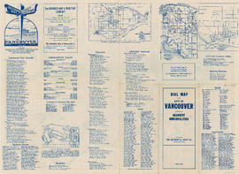
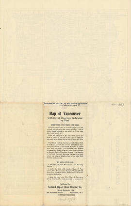
Map of Vancouver with street directory indicated by dial : map cover and street index
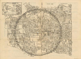
Map of Vancouver with street directory indicated by dial : map

Map of New Westminster and Burnaby with street directory indicated by dial : map cover and street index

Dial map of New Westminster and Burnaby
Map of Vancouver with street directory indicated by dial : Map cover
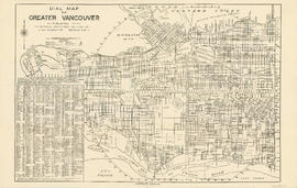
Dial map of Greater Vancouver

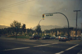
Vancouver street scene

Vancouver Eaton's Centre

Vancouver street scene
Vancouver street scene
Georgia Street

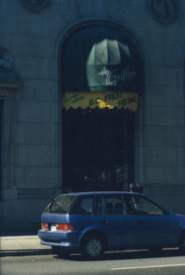
Chinatown

Dial map of Greater Vancouver and suburbs

Map of Lulu Island and Sea Island ; Municipality of Delta ; Municipality of Surrey ; Municipality of Langley ; Map of Maillardville

Street map of Greater Vancouver, B.C.

Map of West Vancouver and North Vancouver, street index, real estate information, and list of golf courses

Water service map of South Vancouver : Vivian Street to Kerr Street and 56th Avenue (54th Avenue) to 67th Avenue (65th Avenue)

Water service map of South Vancouver : Vivian Street to Doman Street and 67th Avenue (65th Avenue) to North Arm of Fraser River

Water service map of South Vancouver : Victoria Drive to Vivian Street and 56th Avenue (54th Avenue) to 67th Avenue (65th Avenue)

Water service map of South Vancouver : Victoria Drive to Vivan Street and 67th Avenue (65th Avenue) to North Arm of Fraser River

Water service map of South Vancouver : Tyne Street to Park Street (Boundary Road) and 56th Avenue (54th Avenue) to 67th Avenue (65th Avenue)

Water service map of South Vancouver : Point Grey boundary to Ontario Street and River Avenue (Marine Drive S.W.) to North Arm of Fraser River

Water service map of South Vancouver : Ontario Street to Fraser Street and River Avenue (Marine Drive) to North Arm of Fraser River

Water service map of South Vancouver : Ontario Street to Fraser Street and 61st Avenue (59th Avenue) to River Street (Marine Drive S.E.)

Water service map of South Vancouver : Knight Street to Victoria Drive and 61st Avenue (59th Avenue) to North Arm of Fraser River

Water service map of South Vancouver : Kerr Street to Tyne Street and 56th Avenue (54th Avenue) to 67th Avenue (65th Avenue)

Water service map of South Vancouver : Fraser Street to Knight Street and 61st Avenue (59th Avenue) to North Arm of Fraser River

Water service map of South Vancouver : Doman Street to Park Street (Boundary Road) and 67th Avenue (65th Avenue) to North Arm of Fraser River

Water service map of South Vancouver : Knight Street to Victoria Drive and 51st Avenue (49th Avenue) to 61st Avenue (59th Avenue)

Water service map of South Vancouver : Fraser Street to Knight Street and 51st Avenue (49th Avenue) to 61st Avenue (59th Avenue)

Water service map of South Vancouver : Ontario Street to Fraser Street and 51st Avenue (49th Avenue) to 61st Avenue (59th Avenue)

Water service map of South Vancouver : Tyne Street to Park Street (Boundary Road) and 46th Avenue (45th Avenue) to 56th Avenue (54th Avenue)

Water service map of South Vancouver : Kerr Street to Tyne Street and 46th Avenue (45th Avenue) to 56th Avenue (54th Avenue)

Water service map of South Vancouver : Vivian Street to Kerr Street and 46th Avenue (45th Avenue) to 56th Avenue (54th Avenue)

Water service map of South Vancouver : Victoria Drive to Vivian Street and 46th Avenue (45th Avenue) to 56th Avenue (54th Avenue)

Water service map of South Vancouver : Knight Street to Victoria Drive and 43rd Avenue (41st Avenue) to 51st Avenue (49th Avenue)

Water service map of South Vancouver : Fraser Street to Sherbrooke Street and 43rd Avenue (41st Avenue) to 51st Avenue (49th Avenue)

Water service map of South Vancouver : Ontario Street to Fraser Street and 43rd Avenue (41st Avenue) to 51st Avenue (49th Avenue)

Water service map of South Vancouver : Ontario Street to Fraser Street and 33rd Avenue to 41st Avenue

Water service map of South Vancouver : Fraser Street to Knight Street and 34th Avenue (33rd Avenue) to 43rd Avenue (41st Avenue)
Water service map of South Vancouver : Knight Street to Victoria Drive and 34th Avenue (33rd Avenue) to 43rd Avenue (41st Avenue)

Water service map of South Vancouver : Victoria Drive to Wales Street and 35th Avenue (34th Avenue) to 46th Avenue (45th Avenue)

Water service map of South Vancouver : McHardy Street to Park Street (Boundary Road) and Government Street (29th Avenue) to Vanness Avenue

Water service map of South Vancouver : area bounded by Vanness Avenue, Government Street (29th Avenue), and McHardy Street

Water service map of South Vancouver : Tyne Street to Park Street (Boundary Road) and Vanness Avenue to 46th Avenue (45th Avenue)