![Strathcona/West End [Children in a park, 2 of 2]](/uploads/r/null/e/7/3/e738f68ed7ad922b383bbad2088d2667cdef9a0615b40de560a946ee59c10976/a1d8f5b6-fe07-4a77-8590-2178f8521a96-CVA1095-15344_142.jpg)
Strathcona/West End [Children in a park, 2 of 2]
- COV-S644-: CVA 1095-15344
- Item
- [1976?]
Part of City of Vancouver fonds
1434 results with digital objects Show results with digital objects
Strathcona/West End [Children in a park, 2 of 2]
Part of City of Vancouver fonds
![Strathcona/West End [Children in a park, 1 of 2]](/uploads/r/null/9/f/d/9fdcd160fb5e8b563c7791c8047f7d0eb2557f5780b829d9627c45c22d29cc5e/7bcb0c35-410d-4231-aec6-23596e23e082-CVA1095-15343_142.jpg)
Strathcona/West End [Children in a park, 1 of 2]
Part of City of Vancouver fonds
![[710 Keefer Street - MacLean Park]](/uploads/r/null/e/d/8/ed8671a637683259819a20c6fde7fb8247bbc53f7028afa7de9ee1ee8de9d13f/fc573c34-217b-4610-a010-285e0cc762ae-CVA1095-15334_142.jpg)
[710 Keefer Street - MacLean Park]
Part of City of Vancouver fonds
![Strathcona/West End [Children in a park]](/uploads/r/null/3/2/8/3287e1bfe414f3468d9e71312b41b103651970660424ccd291f36b724c605118/beced72f-9679-499b-9364-241f499b7a40-CVA1095-15331_142.jpg)
Strathcona/West End [Children in a park]
Part of City of Vancouver fonds
![[200 West Hastings Street - Victory Square]](/uploads/r/null/2/d/f/2df6cc1bdf1035e8481269c24b57d639d42651df4437d60f1352a6b83dee109f/fd907699-bd73-408c-8c4d-559411d924ec-CVA1095-14295_142.jpg)
[200 West Hastings Street - Victory Square]
Part of City of Vancouver fonds
![[Park]](/uploads/r/null/a/d/5/ad5f8deefdf643bc4cbde87ef3053fbdbfc57d871e3fa6cb83bd4b0d28ee8cae/71ede936-d2e3-4559-8b34-1f4a4d9d402b-CVA1095-13802_142.jpg)
Part of City of Vancouver fonds
![[Gazebo at Alexandra Park]](/uploads/r/null/7/5/6/756064a58c1b499e0e1bec7c2d03333db833a388c6c09bcc71db4ffc34a0ae20/cdfd94ae-acfa-46b8-8c5b-f506ed8a3f70-CVA1095-13253_142.jpg)
Part of City of Vancouver fonds
![[201-299 Jackson Street - Oppenheimer Park]](/uploads/r/null/d/6/f/d6fbd2b4dad8f53475e06fae0507f5f01bb14546c98d54f38217b51f14a17a65/3bd443b0-1482-4eed-8cc5-b8addecd3897-CVA1095-12458_142.jpg)
[201-299 Jackson Street - Oppenheimer Park]
Part of City of Vancouver fonds
Everest - original Betacam tape 5
Part of Yaletown Productions Inc. fonds
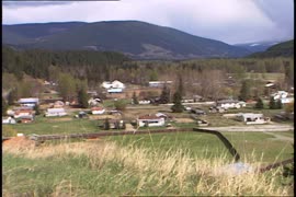
Item is raw footage for the documentary "Everest - Climb for Hope." Includes footage of a small town, people packing food for the "Everest - Climb for Hope" team and an interview with the woman who organized all of the food for the expedition and will be the cook at base camp.
Everest - Climb for Hope; original Betacam tape 3
Part of Yaletown Productions Inc. fonds
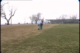
Item is raw footage for the documentary "Everest - Climb for Hope." Includes scenes of Ernie [Erwin] Sniedzins with his daughter Sarah, who suffers from Rett Syndrome, walking together in a park and playing on the swings. Includes some footage of other adults and children at the park, enjoying the outdoors, and playing on the playground. Some nighttime (very dark) footage of a fundraiser candlelight dinner event, in support of Rett Syndrome awareness.

Everest - Climb for Hope; original Betacam tape 2
Part of Yaletown Productions Inc. fonds
Item is raw footage for the documentary "Everest - Climb for Hope." Includes an interview with Ernie [Erwin] Sniedzins about the origins of "The Climb for Hope," its beginnings in 1986, Rett Syndrome the disease and its effect on the Sniedzins family, and he compares climbing Mount Everest to tackling the challenges of Rett Syndrome. There is also scenes of Sniedzins walking in the park with his daughter, Sarah, who suffers from Rett Syndrome.
![[200 West Hastings Street - Victory Square]](/uploads/r/null/2/b/4/2b406af3e32a7b8b10c5708e98773afcc08a629e78616afcd87b177490c9031b/0c983e57-e193-41a0-9e43-7bf614937365-CVA1095-10169_142.jpg)
[200 West Hastings Street - Victory Square]
Part of City of Vancouver fonds
![[East Cordova Street and Jackson Avenue intersection]](/uploads/r/null/a/1/5/a15124685de54414fab7097c3e40f7ea2ea1b91a285beb8e523b0e0d840b1500/9452be55-9af3-44eb-b503-36e12ee8d64a-CVA1095-10000_142.jpg)
[East Cordova Street and Jackson Avenue intersection]
Part of City of Vancouver fonds
![[Oppenheimer Park]](/uploads/r/null/2/a/5/2a5f78381114fd651933671d9706ec7e5a71ed078f83a17ae5b0eeb92bfee8f4/2cc10460-34ea-4d1e-99a0-a1a28a710921-CVA1095-09984_142.jpg)
Part of City of Vancouver fonds

The city of Vancouver, British Columbia
Part of City of Vancouver Archives technical and cartographic drawing collection
Item is a map showing postal block numbers, streets, railroads, schools, steamship routes, beaches and hospitals in the city of Vancouver. The map has been annotated to show city parks.
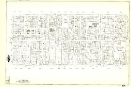
Sheet 64 : Balaclava Street to Cypress Street and Forty-ninth Avenue to Forty-first Avenue
Part of City of Vancouver Archives technical and cartographic drawing collection
Item is a section showing the area from Balaclava Street to Cypress Street and Forty-ninth Avenue to Forty-first Avenue. Includes streets, blocks, lots and legal descriptions, and the locations of parks and schools.
Vancouver (B.C.). Engineering Services

Sheet G : Trafalgar Street to Granville Street and Sixteenth Avenue to Nanton Avenue
Part of City of Vancouver Archives technical and cartographic drawing collection
Item is a section showing the area from Trafalgar Street to Granville Street and Sixteenth Avenue to Nanton Avenue. Includes streets and roads; blocks, lots and legal descriptions; and parks, schools, railway lines and golf courses.
Vancouver (B.C.). Office of the City Engineer

Aerial photo, vertical, Little Mountain and Oakridge and surrounding area
Item is a photograph of Little Mountain and Oakridge, showing from W 30th Avenue to W 54th Avenue, and from Hudson Street to Main Street. Includes the Langara golf course and Queen Elizabeth Park.
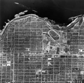
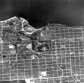
Aerial photo, vertical, Exhibition Park and surrounding area
Item is a photograph of Exhibition Park and the surrounding area, looking north. The area photographed runs from Vancouver Harbour to Charles Street, and from Lakewood Drive to Skeena Street.
Aerial photo, vertical, Jericho Beach Park and Kitsilano
Item is a photograph of Jericho Beach Park and the surrounding area, looking north. The area photographed runs from English Bay and Jericho Beach to W 16th Avenue,and from Sasamat Street to Balaclava Street.
![[HMS Egeria plaque, Stanley Park]](/uploads/r/null/a/0/1/a01da412db16a5c79c647053cefb46c4b396fc60ac0b8825986eafe46961d2d5/1329f37f-9960-4d29-ac7c-295dda8fdd7d-CVA1095-00586_142.jpg)
[HMS Egeria plaque, Stanley Park]
Part of City of Vancouver fonds
![[HMS Egeria plaque]](/uploads/r/null/d/2/0/d2056c0dae8264076fbe68bb66478cab784b11b94440906aa1f6636b16478ead/52f19f3e-b5a8-4e1f-b499-7680c1db4e0d-CVA1095-00038_142.jpg)
Part of City of Vancouver fonds
Image is a photograph that depicts a detail of the HMS Egeria plaque. It contains the following inscription: "This concrete slab was set by the Royal engineers in 1865 and was used as a survey point in 1898 by the Royal Navy ship H.M.S. Egeria."

Stanley Park, four totem poles
Item is a photograph of four totem poles near Lumberman's Arch in Stanley park. The poles are (L-R): the Sisa-Kaulas Pole, the two Thunderbird House Posts pole and the Chief Wakas Pole (second from the right).

Sheet 88 : Macdonald Street to Angus Drive and Edgington Avenue to Fifty-seventh Avenue
Part of City of Vancouver Archives technical and cartographic drawing collection
Item is a section showing the area from Macdonald Street to Angus Drive and Edgington Avenue to Fifty-seventh Avenue. Includes streets, blocks, lots and legal descriptions, and the locations of schools, parks and golf courses.
Vancouver (B.C.). Engineering Services

Sheet 87 : Barnard Street to Heather Street and Beckwith Road to Seventy-fifth Avenue
Part of City of Vancouver Archives technical and cartographic drawing collection
Item is a section showing the area from Barnard Street to Heather Street and the North Arm of the Fraser River to Seventy-fifth Avenue. Includes streets, blocks, lots and legal descriptions, and the locations of schools and parks. Also Includes streets and blocks in Richmond from Beckwith Road to River Drive.
Vancouver (B.C.). Engineering Services

Sheet 86 : Angus Drive to Laurel Street and Seventy-fifth Avenue to Sixty-seventh Avenue
Part of City of Vancouver Archives technical and cartographic drawing collection
Item is a section showing the area from Angus Drive to Laurel Street and Seventy-fifth Avenue to Sixty-seventh Avenue. Includes streets, blocks, lots and legal descriptions, and the locations of schools and parks.
Vancouver (B.C.). Engineering Services

Sheet 85 : Laburnum Street to Fremlin Street and Sixty-eighth Avenue to Fifty-seventh Avenue
Part of City of Vancouver Archives technical and cartographic drawing collection
Item is a section showing the area from Laburnum Street to Fremlin Street and Sixty-eighth Avenue to Fifty-seventh Avenue. Includes streets, blocks, lots and legal descriptions, and the locations of schools and parks.
Vancouver (B.C.). Engineering Services

Sheet 83 : Fremlin Street to Main Street and Southwest Marine Drive to Fifty-seventh Avenue
Part of City of Vancouver Archives technical and cartographic drawing collection
Item is a section showing the area from Fremlin Street to Main Street and Southwest Marine Drive to Fifty-seventh Avenue. Includes streets, blocks, lots and legal descriptions, and the locations of schools, parks and hospitals.
Vancouver (B.C.). Engineering Services

Sheet 81 : Main Street to Inverness Street and Southeast Marine Drive to Fifty-seventh Avenue
Part of City of Vancouver Archives technical and cartographic drawing collection
Item is a section showing the area from Main Street to Inverness Street and Southeast Marine Drive to Fifty-seventh Avenue. Includes streets, blocks, lots and legal descriptions, and the locations of schools and parks.
Vancouver (B.C.). Engineering Services
![[Park covered in snow]](/uploads/r/null/2/4/5/2452f623f1a8f13b316ec1c920ef648ef8e89cc430108f2a5591facd98fd9bf2/ca7e51f3-218d-4cf4-8c84-575ad56b582e-CVA1095-09242_142.jpg)
Part of City of Vancouver fonds
![[West Pender Street and Hamilton Street - Victory Square]](/uploads/r/null/f/0/6/f065b2280bfb1c913d281237d2a00ce47630382f92bd8a22e0ce60ffaba96a8c/3055b6f8-a905-4ef6-b549-b7f42affe4b7-CVA1095-09232_142.jpg)
[West Pender Street and Hamilton Street - Victory Square]
Part of City of Vancouver fonds
![[West Pender Street and Hamilton Street - Victory Square]](/uploads/r/null/e/f/8/ef8b15602a4a2ace2ab3b4676164f8fe00870e50b45c40e8205363f6279ddfbc/918646cc-94b0-497b-995f-eb2ec6d416ff-CVA1095-09221_142.jpg)
[West Pender Street and Hamilton Street - Victory Square]
Part of City of Vancouver fonds
![[Cambie Street and West Pender Street - Victory Square]](/uploads/r/null/5/5/0/55038e6a75af792b1a7eb8ff51193a3a1c5e8f9307571e60e2545fc13f853eeb/d05de9ab-d896-428b-84bf-962df3328d11-CVA1095-09220_142.jpg)
[Cambie Street and West Pender Street - Victory Square]
Part of City of Vancouver fonds
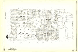
Sheet 77 : Kerr Street to Greenall Avenue and Southeast Marine Drive to Asquith Avenue
Part of City of Vancouver Archives technical and cartographic drawing collection
Item is a section showing the area from Kerr Street to Greenall Avenue and Southeast Marine Drive to Asquith Avenue. Includes streets, blocks, lots and legal descriptions, and the location of parks.
Vancouver (B.C.). Engineering Services

Sheet 76 : Kerr Street to Mondy Avenue and Asquith Avenue to Forty-ninth Avenue
Part of City of Vancouver Archives technical and cartographic drawing collection
Item is a section showing the area from Kerr Street to Mondy Avenue and Asquith Avenue to Forty-ninth Avenue. Includes streets, blocks, lots and legal descriptions, and the locations of schools, parks and cemeteries.
Vancouver (B.C.). Engineering Services

Sheet 75 : Nanaimo Street to Kerr Street and Bobolink Avenue to Forty-ninth Avenue
Part of City of Vancouver Archives technical and cartographic drawing collection
Item is a section showing the area from Nanaimo Street to Kerr Street and Bobolink Avenue to Forty-ninth Avenue. Includes streets, blocks, lots and legal descriptions, and the locations of schools, parks and golf courses.
Vancouver (B.C.). Engineering Services

Sheet 74 : Inverness Street to Nanaimo Street and Sixty-first Avenue to Forty-ninth Avenue
Part of City of Vancouver Archives technical and cartographic drawing collection
Item is a section showing the area from Inverness Street to Nanaimo Street and Sixty-first Avenue to Forty-ninth Avenue. Includes streets, blocks, lots and legal descriptions, and the locations of schools and parks.
Vancouver (B.C.). Engineering Services

Sheet 73 : Quebec Street to Inverness Street and Fifty-seventh Avenue to Forty-seventh Avenue
Part of City of Vancouver Archives technical and cartographic drawing collection
Item is a section showing the area from Quebec Street to Inverness Street and Fifty-seventh Avenue to Forty-seventh Avenue. Includes streets, blocks, lots and legal descriptions, and the locations of schools and parks.
Vancouver (B.C.). Engineering Services

Sheet 72 : Oak Street to Quebec Street and Fifty-eighth Avenue to Forty-sixth Avenue
Part of City of Vancouver Archives technical and cartographic drawing collection
Item is a section showing the area from Oak Street to Quebec Street and Fifty-eighth Avenue to Forty-sixth Avenue. Includes streets, blocks, lots and legal descriptions, and the locations of schools and parks.
Vancouver (B.C.). Engineering Services

Sheet 70 : Macdonald Street to Cypress Street and Fifty-seventh Avenue to Forty-ninth Avenue
Part of City of Vancouver Archives technical and cartographic drawing collection
Item is a section showing the area from Macdonald Street to Cypress Street and Fifty-seventh Avenue to Forty-ninth Avenue. Includes streets, blocks, lots and legal descriptions, and the locations of golf courses, parks and railways.
Vancouver (B.C.). Engineering Services

Part of City of Vancouver Archives technical and cartographic drawing collection
Item is a section showing the area from Musqueam Indian Reserve to Musqueam Park and North Arm, Fraser River to Southwest Marine Drive. Includes streets, blocks, lots and legal descriptions, and parks.
Vancouver (B.C.). Engineering Services

Sheet 66 : Musqueam Indian Reserve to Balaclava Street and Forty-ninth Avenue to Forty-first Avenue
Part of City of Vancouver Archives technical and cartographic drawing collection
Item is a section showing the area from Musqueam Indian Reserve to Balaclava Street and Forty-ninth Avenue to Forty-first Avenue. Includes streets, blocks, lots and legal descriptions, and the locations of schools, parks and golf courses.
Vancouver (B.C.). Engineering Services

Sheet 63 : Carnarvon Street to Cypress Street and Forty-first Avenue to Thirty-third Avenue
Part of City of Vancouver Archives technical and cartographic drawing collection
Item is a section showing the area from Carnarvon Street to Cypress Street and Forty-first Avenue to Thirty-third Avenue. Includes streets, blocks, lots and legal descriptions, and the locations of parks and schools.
Vancouver (B.C.). Engineering Services

Sheet 62 : Cypress Street to Oak Street and Forty-ninth Avenue to Forty-first Avenue
Part of City of Vancouver Archives technical and cartographic drawing collection
Item is a section showing the area from Cypress Street to Oak Street and Forty-ninth Avenue to Forty-first Avenue. Includes streets, blocks, lots and legal descriptions, and the locations of parks and schools.
Vancouver (B.C.). Engineering Services
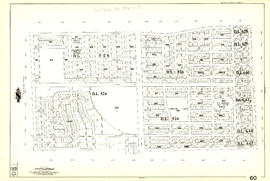
Sheet 60 : Oak Street to Quebec Street and Forty-sixth Avenue to Thirty-seventh Avenue
Part of City of Vancouver Archives technical and cartographic drawing collection
Item is a section showing the area from Oak Street to Quebec Street and Forty-sixth Avenue to Thirty-seventh Avenue. Includes streets, blocks, lots and legal descriptions, and the locations of parks and schools.
Vancouver (B.C.). Engineering Services

Sheet 59 : Quebec Street to Inverness Street and Forty-seventh Avenue to Thirty-seventh Avenue
Part of City of Vancouver Archives technical and cartographic drawing collection
Item is a section showing the area from Quebec Street to Inverness Street and Forty-seventh Avenue to Thirty-seventh Avenue. Includes streets, blocks, lots and legal descriptions, and the locations of parks, schools and Mountainview Cemetery.
Vancouver (B.C.). Engineering Services
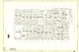
Sheet 58 : Inverness Street to Nanaimo Street and Forty-ninth Avenue to Forty-first Avenue
Part of City of Vancouver Archives technical and cartographic drawing collection
Item is a section showing the area from Inverness Street to Nanaimo Street and Forty-ninth Avenue to Forty-first Avenue. Includes streets, blocks, lots and legal descriptions, and the locations of parks and schools.
Vancouver (B.C.). Engineering Services

Part of City of Vancouver Archives technical and cartographic drawing collection
Item is a section showing the area from Nanaimo Street to Doman Street and Joyce Street and Forty-ninth Avenue to Forty-first Avenue. Includes streets, blocks, lots and legal descriptions, and the locations of parks and schools.
Vancouver (B.C.). Engineering Services

Part of City of Vancouver Archives technical and cartographic drawing collection
Item is a section showing the area from Nanaimo Street to Joyce Street, Cecil Street and McHardy Street and Forty-first Avenue to Ward Street and Vanness Avenue. Includes streets, blocks, lots and legal descriptions, and the locations of parks and schools.
Vancouver (B.C.). Engineering Services

Sheet 53 : Inverness Street to Nanaimo Street and Forty-first Avenue to Thirty-second Avenue
Part of City of Vancouver Archives technical and cartographic drawing collection
Item is a section showing the area from Inverness Street to Nanaimo Street and Forty-first Avenue to Thirty-second Avenue. Includes streets, blocks, lots and legal descriptions, and the location of parks.
Vancouver (B.C.). Engineering Services