- AM75-F26-: LEG1374.09
- Item
- 1929
Item contains a commercial and visitors map of the southwestern land districts of British Columbia on one side and textual information on the region on the other.
11 results with digital objects Show results with digital objects
Item contains a commercial and visitors map of the southwestern land districts of British Columbia on one side and textual information on the region on the other.

Southwestern districts : Map no. 1K : comparative geographical study
Part contains information on the southwestern districts of British Columbia, including population, climate, agriculture, industry, labour, and education; itineraries for exploring the various regions; information on Canadian customs regulations and game regulations; and diagrams of road routes to British Columbia from California and Alberta/western Washington.

Tongass National Forest, Alaska : Copper River Meridian
Item is a map of the Tongass National Forest showing roads, trails, railways, triangulation stations, dwellings, schoolhouses, mines, landing strips, airfields, and international, national forest, and national monument boundaries. Two smaller maps show the location of the Tongass National Forest in relation to the rest of Alaska and the far northwest portion of the forest not shown on the primary map.
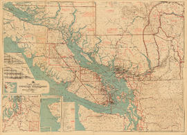
Part contains a commercial and visitors map of the southwestern land districts of British Columbia, encompassing Vancouver Island and the mainland from Seymour Inlet in the northwest to Black Pines in the northeast, extending south to Chiwaukum, Washington. Primary map shows settlements, government agent offices, mining and sub-mining recording offices, game reserves, customs posts, hospitals, ferries, campsites, golf courses, canneries, commercial air harbours, lighthouses, radio stations, motor boat refill stations, power sites, railways, roadways, trails, telegraph and telephone lines, steamship routes, topographic contour lines, and locations of falls and rapids. Text on the map provides information on land features and the presence of wild and farmed animals, and indicates current and possbile agricultural and industrial land use. Inset maps show the northern tip of Vancouver Island, Triangle Island and West and East Haycock Islands, and northwestern Washington State from Seattle to Centralia. A key map shows the location of the area covered by the main map in relation to the rest of North America.

Northerly portion Vancouver Island
Item is a map of northern Vancouver Island and the adjacent British Columbia coast showing Crown and reserve lands, timber leases, district, park, and provincial forest boundaries, cities, municipalities, villages, post offices, hospitals, roads, railways, seaplane ports and anchorages, airports, elevations of some geographical features, and marine distances in nautical miles.

Item is a map of the central British Columbia coast including Haida Gwaii and the mainland from Stewart in the northwest to Kleena Kleene in the southeast. Map shows cities, municipalities, and settlements, post offices, government agents, railways, roads, ferry and steamship routes, air and seaplane ports, parks, campsites, glaciers, customs ports of entry, and elevations of mountains. An small key map shows the primary map's location in relation to the rest of British Columbia and other maps published in the same series.

South western British Columbia
Item is a map of southwestern British Columbia and northwestern Washington showing cities, municipalities, and settlements, post offices, government agents, railways, roads, ferry and steamship routes, air and seaplane ports, parks, campsites, glaciers, customs ports of entry, and elevations of mountains. Inset maps show the islands north of Cape Scott and the Seattle region. An small key map shows the primary map's location in relation to the rest of British Columbia and other maps published in the same series.

Item is a map showing cities and towns, smaller settlements, post offices, railways, roadways, trading posts, ferries, hospitals, telegraph lines, government agents' offices, mining and sub-mining recording offices, falls and rapids, drainage flow, and park, provincial, and international boundaries. An inset map shows the southern Vancouver Island and Lower Mainland area in greater detail. Item includes road, rail, and coastal distance tables, lists of administrative offices and their locations, and an index of post offices.

Item is a copy of a British Columbia Department of Lands map of British Columbia north of the 55th parallel. Map shows cities and towns, smaller settlements, post offices, railways, roadways, trading posts, ferries, hospitals, telegraph lines, government agents' offices, mining and sub-mining recording offices, hatcheries, falls and rapids, drainage flow, and park, provincial, and international boundaries. An inset map shows the far northwest area not shown on the primary map.

Item is a map of the Prince Rupert, British Columbia area showing lands alienated or covered by applications under the Land Act, timber leases, First Nations reserves, land district, provincial forest, and park boundaries, forest management licences, municipalities, post offices, hospitals, sub-mining recording offices, railways, roadways, airports, seaplane anchorages, elevations, telephone and power lines, and glaciers. An index map shows the area covered by the primary map in relation to the rest of British Columbia and other maps published in the series.

Item is a map of the Terrace, British Columbia area showing lands alienated or covered by applications under the Land Act, timber leases, First Nations reserves, land district, provincial forest, and park boundaries, forest management licences, municipalities, post offices, hospitals, sub-mining recording offices, railways, roadways, airports, seaplace anchorages, elevations, telephone and power lines, and glaciers. An index map shows the area covered by the primary map in relation to the rest of British Columbia and other maps published in the series.

Preliminary map : Stikine River
Item is a map of the Stikine River region from Dease Lake in the north to Stewart in the south. Map shows land and timber surveys, government and First Nations reserves, mining division and international boundaries, government agents' offices, mining and sub-mining recording offices, post offices, villages, Hudson's Bay Company posts, telegraph lines, hospitals, schools, radio stations, triangulation stations, railways, roadways, bridges, falls and rapids, glaciers, and topographic contours.