- AM1594-: MAP 373
- Item
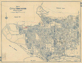
- 1930
Part of City of Vancouver Archives technical and cartographic drawing collection
Map shows proposed route for entry to the Burrard Street Bridge from Cornwall and Cedar Streets. Survey overseen by George Frederick Fountain, Land Surveyor of the City of Vancouver, March 26, 1930. Correctness of survey sworn before H. J. Painter, a notary public for the Province of British Columbia, April 8, 1930.
Vancouver (B.C.). Engineer's Office