
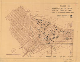
Figure 15 : a circulation pattern for pedestrians
- COV-S445-3---: LEG37.19
- Item
- 1960
Part of City of Vancouver fonds
Map is a plan of downtown Vancouver with areas shaded to indicate streets, squares, malls and arcades, in which the movement of vehicles is not permitted at all or is restricted. Although the entire downtown area is shown, shading pertains only to Jervis Street and Main Street and Burrard Inlet and Nelson Street. Note written in the bottom right corner of the map reads "B 1960 Jan., Traffic Plans, small folder."


![Beautification Problems - #1 [6 of 18]](/uploads/r/null/5/2/52a5fa543e547a81920189dc0e831968be5a540192c7dba1a12c190b9ca38044/368b256b-aad5-4cdb-9f3f-dee00f72789e-A68608_142.jpg)
![City Views from City Hall Roof [19 of 24]](/uploads/r/null/c/a/ca3d15ba4d81c83975b97928f035237b4425c5a29a6684d52b04ed219a337cd7/a60eb6cc-80da-4e0c-910c-7f061c723c7d-A67864_142.jpg)
![City Views from City Hall Roof [18 of 24]](/uploads/r/null/b/8/b8a7473b4694078665501a45fbb5222c49d42eead5c903c6be96a83aa3b99522/4ea08f7e-1727-4cc4-a055-b869b199d0c4-A67863_142.jpg)
![City Views from City Hall Roof [17 of 24]](/uploads/r/null/8/8/88d3bef1c1469ce1cc10bc8fbca23f86c609be30d9831d61a4d50c1b4d64bdf2/81e29215-8eee-48b5-96b4-b0b43141da58-A67862_142.jpg)
![City Views from City Hall Roof [12 of 24]](/uploads/r/null/f/f/ff69edeeb7418181b4b9d33e095bc7cc21c9af4d0e2554b09c831d3bf1f7bd50/429f6a28-039f-489b-adf6-8ea31d84bd36-A67857_142.jpg)
![City Views from City Hall Roof [11 of 24]](/uploads/r/null/a/0/a018839d151ca4930ca9614b7544b42c144e08f545c1771bf1cd47984f66fdb1/b28baada-157a-430e-a277-81d03695e1eb-A67856_142.jpg)
![City Views from City Hall Roof [10 of 24]](/uploads/r/null/f/f/ff40cf9dbb907db14f1d4219dde54d8987d9b9e2b529611b3f6adde8a5a86bdc/18c92d7d-ff19-4ae4-8936-2c25a81257ba-A67855_142.jpg)
![City Views from City Hall Roof [9 of 24]](/uploads/r/null/3/5/35de332ab1bb6a6986eabb4094f4e9ef3934b4e7d7cf874b87ea91884a4c0790/bdd1c21b-19be-4ecf-b8c4-b44d0d6e679d-A67854_142.jpg)
![City Views from City Hall Roof [8 of 24]](/uploads/r/null/8/8/88d6733c1dc509360d7b4d91dcc7fb6c7b7fcddf9f76e1b4bc31701b2a27402b/c512facd-ad25-4a76-87db-003fe2aad56d-A67853_142.jpg)
![Granville Street [11 of 11]](/uploads/r/null/f/b/fb7b44425cb8dbf0c56610a281373d07150fbbeb371b4259209f4f0994ddeccd/6ecf53d2-dc39-469a-a7a8-cd8b54de6f41-A67558_142.jpg)
![Granville Mall [149 of 149]](/uploads/r/null/1/d/1d022476e71ee174ec9bb96d1c7e1b490a8d132e88c03cfe7cc5550216262228/adbb7f52-a5ee-4313-a3e6-7b55dc1f1024-A67557_142.jpg)
![Miscellaneous [118 of 130]](/uploads/r/null/5/7/57403a1f4476c4a743cde572f646f29ae76d74f0efe6c90a7b2b5c5a33013fd9/3849ebe1-cc8a-4342-826c-f8c2a4387bd5-A67550_142.jpg)
![Miscellaneous [117 of 130]](/uploads/r/null/a/4/a49076bf7f21e2d357296433bc7fd1ea2256b52579a7bbc9d0d5d8d441bbff5d/e3382963-8663-4ddd-adee-5344f82b64b8-A67549_142.jpg)
![Miscellaneous [103 of 130]](/uploads/r/null/6/b/6b110a5dcb198fe50cd693c08217a7c1e1af4f4a89ec572715d38d5ce6f0cb44/2c71c224-c28e-4366-81f6-a5f00e629bb1-A67535_142.jpg)
![Cambie Bridge Construction - #18 [13 of 33]](/uploads/r/null/0/9/096793c65ec76c29979d108ee0c1fb7588b424f5a2b2b84ca8625605da0df0de/a17dea34-d587-4eda-96d2-d6ef5c882d23-A66823_142.jpg)
![Cambie Bridge Construction - #18 [12 of 33]](/uploads/r/null/d/9/d912647d27274e8a98f6aa2d55cf8aa5238608bb5543bf4f849ab16ad13cc3c1/233f9972-c2e9-458c-abcb-ab85d415bca9-A66822_142.jpg)
![Cambie Bridge Construction - #18 [11 of 33]](/uploads/r/null/b/1/b140e03cf3f8b2768aed842980d14a75ac9bb3a75c96b835483d630b25d328e7/4a9ef95e-6051-4368-93a5-5c25fcb73864-A66821_142.jpg)
![Cambie Bridge Construction - #18 [10 of 33]](/uploads/r/null/c/0/c0d67c9c87297604bbf54ef823839f6652b17b6548b49d2256283ab4c6f665e0/cff8dcf9-0710-4984-9794-9955aec4fc23-A66820_142.jpg)
![Cambie Bridge Construction - #18 [9 of 33]](/uploads/r/null/6/b/6b899a7bfa122238d71be0bee6cc7eb15713d49432659b5724177b09c16fd663/1e884466-8f56-44b2-a90d-9f1e06566ef1-A66819_142.jpg)
![Cambie Bridge Construction - #18 [8 of 33]](/uploads/r/null/6/7/67074309c1f9e4c153508701041c7c39e84ce1c9ec97366c90a47340c94d2d15/216e8bed-bb14-4c20-89d3-9241bc666f02-A66818_142.jpg)
![Cambie Bridge Construction - #18 [7 of 33]](/uploads/r/null/5/d/5d8554dd15e6c4df58e3e5efc6cd47504da9514c84cfce04adfb6c5f0dde27b3/d84d0ec5-c117-469e-8316-bb6c50632b9b-A66817_142.jpg)
![Cambie Bridge Construction - #18 [6 of 33]](/uploads/r/null/a/d/add56eb7392e41930d7533a1c3227f2b2ea55a9b901591d98d24c33709362558/2067c19c-0476-48bc-936a-8c2c1027ed3f-A66816_142.jpg)
![Cambie Bridge Construction - #18 [5 of 33]](/uploads/r/null/e/7/e7d572cfcbd5bb83c7f8aad117dd677c521787e10c853a79f4c2b7737f330aa7/651345e7-c7ae-40f4-bf18-a1571796f3d1-A66815_142.jpg)
![Cambie Bridge Construction - #18 [4 of 33]](/uploads/r/null/1/6/16c88fcec1ec5acee0246429148a2a64fd695a7449c59cc95748d281ae8adc6d/78c0fe89-0684-4c98-8ea4-0eca386b1ed1-A66814_142.jpg)
![Cambie Bridge Construction - #18 [3 of 33]](/uploads/r/null/c/d/cdcd44c17c2b364502b5f104403ebdf949902564b3a614fd3635d5ad9ff15308/e4c7f3f4-5d32-4a0b-95d9-8d5af83e8524-A66813_142.jpg)
![Cambie Bridge Construction - #18 [2 of 33]](/uploads/r/null/3/4/34e1d5e1a601e98759df0242245128775d150e375757d1298bd0f42bf40d0bd3/90227bce-9ef6-4f93-9226-f8bf655b46c2-A66812_142.jpg)
![Cambie Bridge Construction - #18 [1 of 33]](/uploads/r/null/6/e/6e3ba74e493b6415bef92b068adc38fce2967be050157f4b1aed59de73e36854/dbc8d1f3-f237-4a69-b72d-1ae8b54a232d-A66811_142.jpg)
![City Views from City Hall Roof [7 of 24]](/uploads/r/null/9/0/900adf3e242ed8bb0d4f3bd99642c44581c6add77f6bcd53f5536087314fb580/139c5915-54d6-4e0c-80fd-9e6639365c32-A66810_142.jpg)
![City Views from City Hall Roof [6 of 24]](/uploads/r/null/2/c/2c129a24401a15df2ffd2423fe7732f8b97dfff0d6d29e63b0b8b131f2412250/702c1a2e-d423-4a78-a934-8c57691aca81-A66809_142.jpg)
![City Views from City Hall Roof [5 of 24]](/uploads/r/null/1/7/17452a8c5a34698be580091565b6f62a777ccd19554ea559eee7838c061408f8/36ebcb3e-ca44-45d4-8956-606ff3add440-A66808_142.jpg)
![City Views from City Hall Roof [4 of 24]](/uploads/r/null/8/3/838149b25c50d566912553b7be4eb9b6debbdd7ce2d34231ac89fd3886ab4f2f/b5a750d0-3cca-4c8f-99f9-583fd1e31340-A66807_142.jpg)
![City Views from City Hall Roof [3 of 24]](/uploads/r/null/8/7/870947f27bd17e5bb00091e9365bb5b963d413dfaf0068392f1c0cf277720d3c/54567b90-d12a-481e-9431-559c56816e6f-A66806_142.jpg)
![City Views from City Hall Roof [2 of 24]](/uploads/r/null/6/4/64e51364908ef4a930564b0576e93119f6468f4ddc6c519d6701d5d198d72bdd/825b1251-eb8b-4f2f-b8c1-6138af90e367-A66805_142.jpg)
![City Views from City Hall Roof [1 of 24]](/uploads/r/null/8/5/856662885bdcb05dc18466467b60b099174741c5c7f9c8e58e8c9bf1b890fb5d/09978ada-faa3-49d2-ad18-9989250e9d7a-A66804_142.jpg)
![Cambie Bridge Construction [61 of 76]](/uploads/r/null/a/6/a694079b631e703adf0fe8d5958a6e28b54a122855e353a42a83b9302558b033/52163442-2d49-4ed3-a3b2-3c52e0bd65dc-A66771_142.jpg)
![Granville Mall [148 of 149]](/uploads/r/null/f/6/f608df0142d3c2bc2141b9d87cf6764933446073e67f64f43e25dba9bda6d323/3179a137-8325-48dd-84c9-fc0c1428b8d2-A66512_142.jpg)
![Granville Mall [147 of 149]](/uploads/r/null/8/f/8f95478a58c2f8586a7838da4d52264c5a6049f48b5a4d50f9ece61fe5de911e/0e0d21b3-52ed-402e-a859-ef704d3e05ca-A66511_142.jpg)
![Granville Mall [146 of 149]](/uploads/r/null/f/d/fd5f2cd344c5c23787289472ece8f769a816b8a8bd251065b97557da7272f438/8aaae0da-e136-4dcd-9ab5-ce71da9040cf-A66510_142.jpg)
![Granville Mall [145 of 149]](/uploads/r/null/c/7/c77eb6cf2ac50d07507a7a339bd1b1ccffde331c2a8f8ea8a1724e940370fbae/70bf0d92-8d96-4e60-ab07-4eec1aa9215b-A66509_142.jpg)
![Granville Mall [144 of 149]](/uploads/r/null/a/5/a5066c40cf58caeec101227099d0ef905b12abaa42ca2a8aed041e101c1be74f/28b34102-ac6e-407d-9a50-ca68ea4490e2-A66508_142.jpg)
![Granville Mall [143 of 149]](/uploads/r/null/4/c/4c8bd7fced8085fef7c18773e3b86459213867e7b02399b9a6f8177b2d58ff15/e64b7f78-9f1a-484e-985b-1ac46002cb97-A66507_142.jpg)
![Granville Mall [142 of 149]](/uploads/r/null/1/1/1175078a80333f311a730bf1a74189cbbc5d924e19721bb2c1f85b252330288f/3855fc6f-fe7a-4e2a-83e5-57e74f9e32ea-A66506_142.jpg)
![Granville Mall [141 of 149]](/uploads/r/null/7/b/7b7a8c84f4c46d4ba11ad4e8c41b068b65dcc58280f749f766fccf0284829dec/101e3650-ba09-4db1-bf67-fb66bc7d937a-A66505_142.jpg)
![Granville Mall [140 of 149]](/uploads/r/null/2/8/28ccd7b47f649c95efa2d489687947a26ed649fd606546ed202f473f05c9a23c/386c0ab1-c025-4dfc-9b89-8545b10f123f-A66504_142.jpg)
![Granville Mall [139 of 149]](/uploads/r/null/7/3/73fe5579f501399bed55244bfd1371f98c7fff01c3fac677e8bbe346fcb46d00/1c7d8f9b-72ae-4af3-be27-1b819c4254c8-A66503_142.jpg)
![Granville Mall [138 of 149]](/uploads/r/null/3/1/31c8677bb30920f3f92629f097e16c8cba4a876f6b01eb16cc19b1bd71ecf9a4/8aa4af53-cc81-45c9-a551-0589967442eb-A66502_142.jpg)