
Macadamizing King Edward Avenue and Heather St.
- AM1576-S6-12-F12-: 2011-010.1865
- Item
- 1912 (reproduced ca. 1984)
17 results with digital objects Show results with digital objects
Macadamizing King Edward Avenue and Heather St.
Road building crew with shovels in South Vancouver
Road building crew with steam roller in South Vancouver
Photograph shows Frederick Iggulden Sr. holding a shovel.
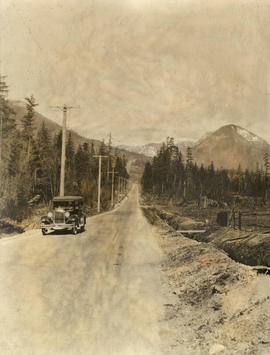
Center Road leading to the Grouse Mountain Highway

Grouse Mountain Highway under construction
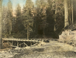
Grouse Mountain Highway from Thunderbird Bridge
Photograph shows 2 men and tractor on bridge.
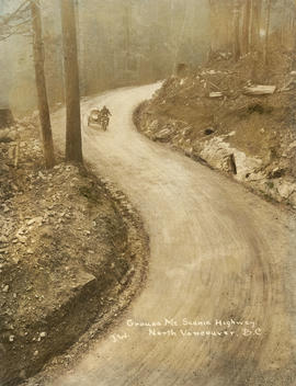
Grouse Mt. Scenic Highway, North Vancouver, B.C.
Photograph shows person driving motocycle with sidecar.

Switchback in Grouse Mountain Highway

Grouse Mountain Highway from Thunderbird Bridge
Photograph shows 2 men and a tractor on bridge.
Four men on rock hauling train
Item shows Jesse Eaton, Ed Eaton, Jack Clode, and Billy Preston standing on train used to haul rock from Little Mountain for fill on Main Street.

Part of City of Vancouver fonds
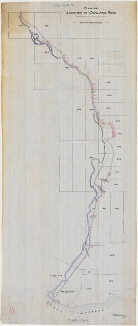
Plan of location of Capilano Road
Part of City of Vancouver fonds
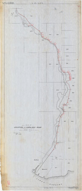
Plan of location of Capilano Road
Part of City of Vancouver fonds
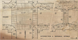
Intersection and sidewalk details
Part of City of Vancouver fonds
Item is a drawing showing paving and lighting design for the intersection of Pender Street and Columbia Street and part of Pender Street east of Columbia Street.
![Plan (in red) showing a suggested bye-pass [sic] road at south end of bridge to avoid cars making...](/uploads/r/null/5/f/a/5fa882ee3603828c85df983159b220e0d7d55438efe1ba4b847e4f6dff6a97f1/dae4a3ae-0095-4c04-bb66-221ef23eeafd-LEG1364_142.jpg)
Item is a map of the Prospect Point area annotated to show a suggested bypass road at the south end of the First Narrows Bridge. Base map shows roadways approaching the proposed First Narrows Bridge, locations of hydrants, topography, and details of landscaping in some areas, and includes two elevations of a proposed skew bridge.
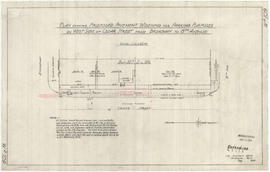
Plan showing proposed pavement widening for parking purposes
Part of City of Vancouver fonds
Vancouver (B.C.). Engineer's Office

Plan and profile of 4th Avenue from Lakewood Dr. to Templeton Dr.
Part of City of Vancouver fonds
Vancouver (B.C.). Engineer's Office

Viaduct from Burrard Bridgehead to Arbutus St. at 6th Ave
Part of City of Vancouver fonds
Item is a technical drawing which depicts an oblique aerial view of the south end of the Burrard Street Bridge and surrounding area, with a design for a proposed viaduct running from the south bridgehead south-westward over Kitsilano to Arbutus Street.
Vancouver (B.C.). Engineer's Office

Plan & profile of south side of First Ave., between Renfrew St. & Nootka St.
Part of City of Vancouver fonds
Vancouver (B.C.). Engineering Services
Vancouver Park Board

Men laying power cables under Smithe Street
Part of Major Matthews collection
Photograph shows men laying two 11,000 volt cables under street. Photograph shows The corner of Smithe Street and Granville Street looking east.