Jericho Park Habitat Survey Volume A and Volume B
- AM484-S14--
- File
- May 2011
264 results with digital objects Show results with digital objects
Jericho Park Habitat Survey Volume A and Volume B
Christmas Bird Count data collection sheets, 1995
Christmas Bird Count data collection sheets, 2001
Christmas Bird Count data collection sheets, 2002
Christmas Bird Count data collection sheets, 2008
Christmas Bird Count data collection sheets, 2010
Christmas Bird Count data collection sheets, 2013
Christmas Bird Count data collection sheets, 2015
Jericho Park Habitat Survey Data Form sheets
Christmas Bird Count data collection sheets, 1996
Christmas Bird Count data collection sheets, 1997
Christmas Bird Count data collection sheets, 1999
Christmas Bird Count data collection sheets, 2003
Christmas Bird Count data collection sheets, 2004
Christmas Bird Count data collection sheets, 2005
Christmas Bird Count data collection sheets, 2006
Christmas Bird Count data collection sheets, 2016
Christmas Bird Count data collection sheets, 2017
Jericho Park Habitat Survey Data Form sheets
Christmas Bird Count data collection sheets, 1998
Christmas Bird Count data collection sheets, 2000
Christmas Bird Count data collection sheets, 2007
Christmas Bird Count data collection sheets, 2009
Christmas Bird Count data collection sheets, 2011
Christmas Bird Count data collection sheets, 2012
Christmas Bird Count data collection sheets, 2014
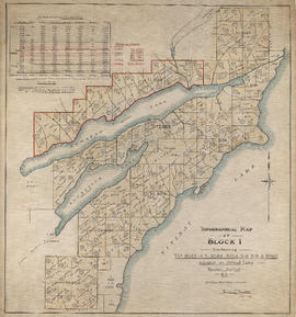
Topographical map of Block 1 containing T.L.s 8043-4-5, 8048, 8054-5-6-8-9 & 8086
Part of Eustace Smith Ltd. fonds
![Miscellaneous [60 of 130]](/uploads/r/null/9/e/9ed32a03560d6a3a2c68861822f9fd15db32eb1d7bb2dddb194adba406842fce/583e7e72-0708-4d02-a88a-cd4a1a78ddc4-A64391_142.jpg)
Part of City of Vancouver fonds
![Mr. Chas Coburn [Copy of survey map of Zeballos]](/uploads/r/null/9/f/d/9fd592159853676e0317c030c447451cc252f4c835e7616d3215f851a12a5e48/95a518bd-678c-473f-abb2-e66b47c90e95-CVA99-7332_142.jpg)
Mr. Chas Coburn [Copy of survey map of Zeballos]
Part of Stuart Thomson fonds

Cheakamus power survey for City of Vancouver 1930-1931. General plan and profile
Part of City of Vancouver fonds
Item is a map depicting south-western British Columbia and noting the location of the area covered by the plates in the atlas. The sheet also includes a profile of the survey area from Cheakamus Lake to Garibaldi Lake.

Part of City of Vancouver fonds
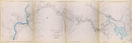
Item is a group of charts depicting flows by month measured at various points along the Cheakamus River.

Part of City of Vancouver fonds
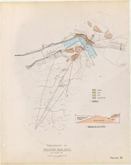
Item is a topographic map of Cheakamus Lake, showing elements of the proposed power infrastructure. The map also includes an inset topographic map of the proposed dam site and a capacity diagram of Cheakamus Lake.
Part of City of Vancouver fonds
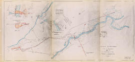
Item is a map sheet containing three topographical maps, depicting the Cheakamus River and Brandywine Creek, the dam site at Brandywine Creek ,and the proposed dam site near McGuire. The sheet also includes sectional drawing of the McGuire dam site, as well as charts of pondage at McGuire and Brandywine.

Cheakamus power survey for City of Vancouver 1930-1931. Proposed storage reservoir at Daisy Lake
Part of City of Vancouver fonds
Item is a map sheet containing two maps depicting portions of the Cheakamus River at or near Daisy Lake, with proposed power infrastructure. The sheet also contains charts depicting a capacity diagram for Daisy lake reservoir and cross-sections at Dyke #1 and Dyke #2.

Part of City of Vancouver fonds

Part of City of Vancouver fonds
Part of City of Vancouver fonds

Part of City of Vancouver fonds

Part of City of Vancouver fonds
Item is a sheet depicting a topographical map of the planned development from Garibaldi Lake to Daisy Lake. The sheet also includes a profile along the proposed tunnel and pipeline route.

Topographical map of Garibaldi Park
Part of City of Vancouver fonds
Item is a copy of a Government of British Columbia Lands Department map which has been used as a base map to depict elements of the proposed development. Annotations depict routes of pipleines and tunnels; locations of powerhouses, dams and shafts; and acreages of affected areas.

Topographical map of parts of the Cheakamus and Green River Valleys
Part of City of Vancouver fonds
Item is a copy of a Government of British Columbia Lands Department map which has been used as a base map to depict elements of the proposed development. Annotations depict acreages of affected areas.

Cheakamus River valley with possible dam location
Part of City of Vancouver fonds
Item is a sheet with three maps depicting a possible dam site on the Cheakamus River: a topographical map of the site with the dam location annotated, a cross-section depicting the geology of the dam site, and a profile of the tentative location of a tunnel.

Cheakamus River with proposed dam site at McGuire
Part of City of Vancouver fonds
Item is a sheet with three maps depicting a possible dam site on the Cheakamus River near McGuire: a topographical map of the site with the dam location annotated, and a cross-section depicting the geology of the dam site.
Topography of proposed dam site
Part of City of Vancouver fonds
Item is a sheet with two maps depicting a possible dam site on the Cheakamus River: a topographical map of the site with the dam location annotated, and a cross-section depicting the geology of the dam site.
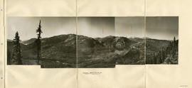
Panorama - Green River Valley from Green lake toward Pemberton Valley
Part of City of Vancouver fonds

Head of Callaghan Creek and Lower Callaghan Lake
Part of City of Vancouver fonds
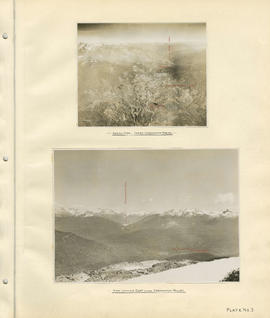
Aerial view - Lower Cheakamus Region and View looking east across Cheakamus Valley
Part of City of Vancouver fonds
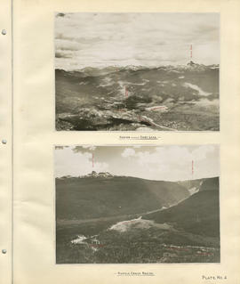
Region around Daisy Lake and Rubble Creek region
Part of City of Vancouver fonds
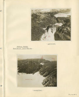
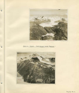
Aerial views - Garibaldi Lake region
Part of City of Vancouver fonds
Aerial views - Garibaldi Lake region
Part of City of Vancouver fonds