![[Dunbar Heights Realty]](/uploads/r/null/6/4/64b6c4b5170643277f41a045d1ebf9ff2918622e2c48f1aaacde0bd858bf7de2/f3b6704b-5f83-4696-9787-ee9690c084a1-A73282_142.jpg)
- AM1533-S2-4-: 2009-005.288
- Item
- [192-]
Part of Dunbar History Project fonds
Item filed under Retail and commercial development.
39 results with digital objects Show results with digital objects
Part of Dunbar History Project fonds
Item filed under Retail and commercial development.
Part of Dunbar History Project fonds
Item filed under Retail and commercial development.
Welcome home : Believe! : go Canada
Advertisement for realtor Sheila O'Brien, using the Olympics theme, "Believe!"
![Real estate [advertisements and group of men assembled around] log](/uploads/r/null/0/0/8/008b32e4a95a923ad3ac03b48632a51e7497cbc01750fe89a33c0213bcacd22a/a280620f-fbdc-471d-908a-191cc9730513-2011-010_142.jpg)
Real estate [advertisements and group of men assembled around] log
Item is a photographic reproduction of a photograph showing a group of men assembled around a large log with an advertisement promoting the sale of Vancouver real estate. The photograph can also be found under the identifier LGN 453 and LGN 454 in the COV Archives holdings.
Infinitely exclusive : the last waterfront masterpiece in Coal Harbour : three harbour green
"Celebrating the completion of Three Harbour Green, Aspac Developments unveils its reserved Collection of Grand Residences"
Strategics Greater Vancouver Condominium Market Review - November 2000
File consists of one report on the condominium market in Greater Vancouver in 2000. The report includes the following sections:
In addition, the report includes details about condominium projects in the following geographic areas:
City Magazine : fall 1984: vol. 7: no. 4
Includes letter from Harry Rankin, "Vancouver: Rights for the rich" regarding the Real Estate Board of Greater Vancouver.

Mr. & Mrs. (nee. Roberta Nisbet) Charles F.H. Steele in front of Charles Steele Real Estate premises
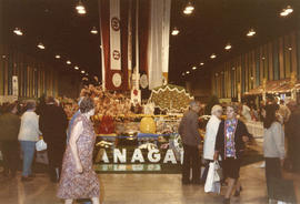

Black Mountain Ranch display booth

Grouse Mountain Resort display booth
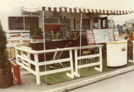
Sudden Valley real estate display trailer


Block Brothers 108 Recreational Ranch display booth

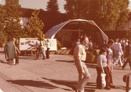
Norcon Development ski cabin display

Sun Mark Properties Ltd. Sudden Valley display booth

Sun Resorts Inc. display trailer on grounds

Carlsberg of Canada Klamath River Country Estates display booth on grounds

Harrison Holiday Park display booth on grounds

Century 21 Realty display booth on grounds
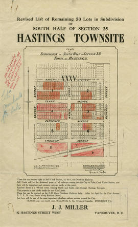
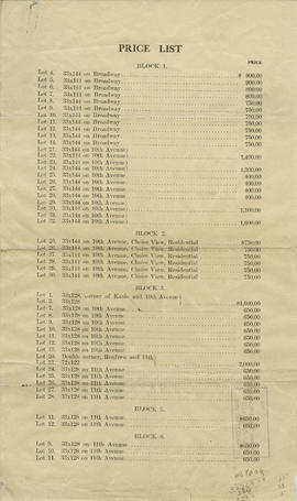
Revised list of remaining 50 lots in subdivision of south half of section 35, Hastings Townsite
Part of City of Vancouver Archives technical and cartographic drawing collection
Part contains a map showing lots for sale in the area bounded by Slocan Street, Renfrew Street, 9th Avenue, and 13th Avenue, and textual information for potential buyers. Annotations indicate which lots were sold.

Price list of new subdivision : Hastings Townsite, close to city limits
Part of City of Vancouver Archives technical and cartographic drawing collection
Part contains a price list and map showing lots in the area bounded by Slocan Street, Renfrew Street, 9th Avenue, and 12th Avenue. Annotations indicate different prices than those listed.
Part of City of Vancouver Archives technical and cartographic drawing collection

Part of City of Vancouver Archives technical and cartographic drawing collection
Part contains a map of East Vancouver Heights showing streets, block numbers and lot numbers, an index map showing the location of East Vancouver Heights in relation to the rest of the city, and text promoting the area.
Bird's eye view of Vancouver, B.C.
Part of City of Vancouver Archives technical and cartographic drawing collection
Part contains an illustrated oblique view of Vancouver showing steamship lines, bridges, beaches, major roads, and the location and block numbers of East Vancouver Heights.

Part of City of Vancouver Archives technical and cartographic drawing collection
Part contains an illustrated map of West Vancouver and North Vancouver showing major streets, mountains, rivers and creeks, and recreational attractions; a street index to the Greater Vancouver map on the other side of the sheet; a list of golf courses; and real estate information including a description of professional realtors, an amortization table, and calculations showing amounts paid in rent over many years.

Plan of the Town of Port-Moody, British Columbia
Part of City of Vancouver Archives technical and cartographic drawing collection
Item is a map showing Port Moody District Lots, blocks and lots, street names, and the "C. P. [Canadian Pacific] Railway Station" and the "C.P.R. [Canadian Pacific Railway] Wharf."
City of Vancouver : Canadian Pacific town site
Part of City of Vancouver Archives technical and cartographic drawing collection
Primary map shows lot numbers and boundaries, streets, fire limits and "soundings in feet" (in English Bay, Burrard Inlet, Coal Harbour and False Creek) in downtown Vancouver, Stanley Park and parts of Kitsilano and Fairview. The ancillary maps show an "Index plan of Vancouver, B.C.", an "Index plan of [Vancouver] city limits" and "Canadian Pacific Mail Steamship Lines" (a map of Canadian Pacifc steamship routes around the world). On recto, the item also includes a description of Stanley Park and an illustration of Vancouver's inner harbour. On verso, the item includes descriptions of major Vancouver residences, imports, exports, businesses and other landmarks.

Map of New Westminster District, B.C.
Part of City of Vancouver Archives technical and cartographic drawing collection
Map shows lot numbers and municipal boundaries in the area from Pitt Lake in the north to the United States border in the south and from the municipality of Coquitlam in the east to Point Atkinson in the west.
Map of Greater Vancouver and Lower Mainland area
Part of City of Vancouver Archives technical and cartographic drawing collection
Item is a brochure with various street maps of Greater Vancouver, folded and enclosed in an attached folder with promotional material on the Vancouver Real Estate Board and information on sites of interest in the area.
Vancouver, B.C., the Pacific coast terminus of the C.P.R. [Canadian Pacific Railway]
Part of City of Vancouver Archives technical and cartographic drawing collection
Item is a map and guide to Vancouver that has been annotated with text and colour to reflect the progress of a land clearance plan carried out in June 1888.

Port Moody, the western terminus of the Canadian Pacific Railway
Part of City of Vancouver Archives technical and cartographic drawing collection
Item is a map showing lots surveys and made available for purchase in Port Moody.

Part of City of Vancouver Archives technical and cartographic drawing collection
Item is a map showing lots for sale in the Grandview District.
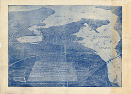
![[Aerial map of Greater Vancouver]](/uploads/r/null/5/6/0/560c4a977bf4bd23ded38e3e8d0c471a86a303d135869c5e459d1977eeed33a6/f660f804-da91-422b-9622-82ae60a89bbe-MAP358_142.jpg)
[Aerial map of Greater Vancouver]
Part of City of Vancouver Archives technical and cartographic drawing collection
Map is a poster of an aerial photograph showing Vancouver, North Vancouver, West Vancouver, Richmond, Burnaby, Delta, Coquitlam, Port Coquitlam, Port Moody, and Surrey. It also shows location of Sea Island Industrial Park and Lake-City Industrial Park which Webb & Knapp sponsor. "Lake-City Industrial Park and Sea Island Industrial Park, comprising approximately 900 acres of industrial estate property".
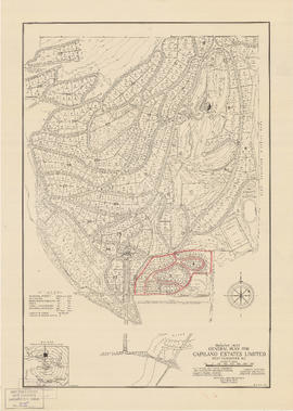
General plan for Capilano Estates Limited
Part of City of Vancouver Archives technical and cartographic drawing collection
Item is a map showing the layout of the proposed Capilano Estates development, including a golf course, a polo field, riding stables, housing lots, and park land. Annotations are pencil outlines of blocks in the southern end of the development.
Brochure regarding sales of provincial government property in Vancouver
Part of City of Vancouver Archives technical and cartographic drawing collection
Item is a brochure advertising the sale of land in Vancouver owned by the provincial government. One side of the unfolded brochure is promotional text and an index map showing the general location of the lands to be sold. The reverse of the sheet shows a portion of District Lot 192 and the lots available for sale.

Part of City of Vancouver Archives technical and cartographic drawing collection
Item is a map depicting lot boundaries and lot dimensions, possibly showing lots for sale.

City of Vancouver : Canadian Pacific town site
Part of Major Matthews collection
Item is a map showing lot numbers and street names in Vancouver's West End from Boundary Avenue (now Glen Drive) in the east to Chilco Street in the west and Kitsilano (from First Avenue in the north to Fifth Avenue in the south and from Heather Street in the east to Vine Street in the west). The three inset maps are a map of "Canadian Pacific mail steamship lines" around the world, an "Index plan of Vancouver, B.C." and an "Index plan city limits".

Warehouse and store sites : very centrally located
Part of City of Vancouver Archives technical and cartographic drawing collection
Item is a flyer advertising the sale of a number of lots in the block bounded by Gore Avenue, the Canadian Pacific Railway right-of-way, and Alexander Street. The flyer includes a list of the lots for sale and asking price, as well as a map of the site.
Municipality of Point Grey : sale of municipal-owned lands
Part of City of Vancouver Archives technical and cartographic drawing collection
Item is a promotional leaflet advertising properties for sale in Point Grey. One side contains a map showing lots for sale; the other contains text describing the Point Grey area and explaining the conditions of sale.
The Estate of Joseph Martin, K.C., MP
Part of City of Vancouver Archives technical and cartographic drawing collection
Item is a promotional brochure advertising the sale of lots from the former estate of Joseph Martin, K.C., MP.
Map of Vancouver, B.C., and vicinity
Part of City of Vancouver Archives technical and cartographic drawing collection
Item contains a map of Greater Vancouver showing major roads on one side, and a map of downtown Vancouver showing businesses on the other. Text surrounding the map of downtown gives facts about British Columbia, lists principal buildings in Vancouver and provides information about the development of the City of Vancouver.
Vancouver, B.C., Pacific terminus of the C.P.R.
Part of City of Vancouver Archives technical and cartographic drawing collection
Item is a brochure published by a real estate development company, promoting the city and its properties. The front side of the unfolded brochure contains information about the city, about Ross and Ceperley, and has information about prominent buildings, many with photographs or illustrations.
Map of Vancouver, B.C. including Hastings Townsite and D.L. 301
Part of City of Vancouver Archives technical and cartographic drawing collection
Item is a map which shows Vancouver city streets, blocks, parks and neighbourhood boundaries. Map includes Kitsilano, Shaughnessy Heights, West End, Fairview, Mount Pleasant, Grandview, Rosedale and Hyde Park areas. Map also indicates steamship, car and railway lines.
The map was originally designed to be folded and enclosed in a small folder to which it was attached.
![Plan of town of Lonsdale : situate [sic] on harbour opposite City of Vancouver](/uploads/r/null/c/5/d/c5d4b56db1d7f9e1cf57dd5a974f6fcb23507e64543bad1bdd8f62139042389f/1cc57eaf-6c92-438e-a65d-335940738df7-MAP686_142.jpg)
Plan of town of Lonsdale : situate [sic] on harbour opposite City of Vancouver
Part of City of Vancouver Archives technical and cartographic drawing collection
Map shows lot numbers and boundaries in the area from Keith Road in the north to Burrard Inlet in the south and from St. Patrick's road in the east to Chesterfield Avenue in the west. Several lots at St. Andrews Road and Fourth Street are hand-coloured pink, but the significance of the colouring is unknown. The ancillary map is an index map showing the location of Lonsdale in relation to Burrard Inlet and Vancouver.
Part of City of Vancouver Archives technical and cartographic drawing collection
Item is an advertisement for real estate in the area bounded by Campbell Street (Alma Street), Richards Street (Balaclava Street), English Bay, and 15th Avenue, with a map of properties on one side and textual advertisements on the other.
Part of City of Vancouver Archives technical and cartographic drawing collection
Item is an advertisement for real estate in East Vancouver Heights, with a map of the subdivision and promotional text on one side and an illustrated oblique view of Vancouver on the other.
Revised list of remaining 50 lots in subdivision of south half of section 35, Hastings Townsite
Part of City of Vancouver Archives technical and cartographic drawing collection
Item contains maps and information regarding lots for sale in the area bounded by Slocan Street, Renfrew Street, 9th Avenue, and 12th Avenue in Hastings Townsite. Sheets include annotations indicating changes in pricing and lots sold.