Item is a videotape that contains a newscast reporting on the ceremonial lighting of the Peace Flame Monument in Seaforth Park. Hosted by Michael Blacklock and Helen Griffiths, the newscast begins with stock images of war and Hiroshima. Newscast contains previously recorded interviews with: Kinuko Laskey (Hiroshima survivor and founder of the Canadian Society of Atomic Bomb Survivors), Larry Beasley (Manager of Legacies project), Joy Leach (Chairman of board at Vancity Savings), Sam Carter (Project Sculptor) and Judith Reid (Design Team Coordinator). After the interviews the feed switches to live footage of the ceremonial lighting of the Peace Flame Monument and speeches. David Leary is Master of Ceremonies. Speakers include: Mayor Gordon Campbell, Chris Richardson (Vancouver Park Board), H.P. Bell-Irving, Thelma Ruck Keene (Activist for Canadian Peace Movement), Walter Krawciw (Petro Canada), and Joy Leach. Gordon Campbell presents certificates to sponsors of the monument. Kinuko Laskey and Gordon Campbell light the flame (no audio). When they return to the stage a children's choir sings "Let there be peace on earth." Gordon Campbell then reads a message from the mayor of Hiroshima, Takeshi Araki. Kinuko Laskey concludes by speaking about her experience at the time of Hiroshima and the work she has been a part of since.

![Be-In at Kits [Kitsilano] Beach](/uploads/r/null/e/0/2/e02581acee80a617122f28024fdaf04bd3bbcba12b25722e9b7dde1a001fbc97/45bd99a8-93e1-499d-9a94-2f7c13aa6d79-MI-590_142.jpg)


![Canadian Pacific map of Vancouver [west half]](/uploads/r/null/f/a/fa49266d21715d75ce93883012d471657dd058b90843927ec82b44d2bb42b007/f12ea9a5-4914-4db8-bda9-312aa2e2ccef-MAP10_142.jpg)

![Vancouver, B.C. Plan showing location of water pipes, hydrants, etc. [Kitsilano]](/uploads/r/null/0/e/0e33cc4d2f081f551fe6919d35ea37236a6e237a2f5927834d275556995fccfc/0f6ac1ff-8457-41f3-a386-26328c66a4b0-MAP72_142.jpg)

![[View looking northeast from First Avenue showing the Burrard Bridge]](/uploads/r/null/5/3/533c19a9698ad9d74e09c288dc0d51d4299e9b82b35f9409a5e27cf3e468ae4e/0eb6cc5d-59c1-44e7-a0fc-c6ecd92b7a35-A19156_142.jpg)


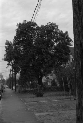


![Magnolia X soulangiana [Museum of Vancouver]](/uploads/r/null/c/d/2/cd2d0e8d3d992612c8f2b76bb50ece5d2b927ed07e26d176c7ff3eb28967f1da/2829c79a-7d75-42e2-86c6-30d84537cfba-CVA792-050_142.jpg)
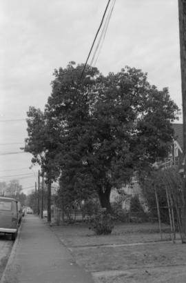
![Magnolia X soulangiana [Museum of Vancouver]](/uploads/r/null/c/9/c/c9ce05462aea3e28aa656b2f70acd5a544c9a30b95f1e3b3393ea110059233ca/0b66085b-a278-4c84-aa53-672f387c6d70-CVA792-049_142.jpg)