
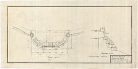
Lavatory west end of Kitsilano pool
- VPK-S98---: LEG1969.28
- Item
- [1931?]
Item is an architectural drawing that depicts plans, sections and elevations.
Vancouver Park Board
7 results with digital objects Show results with digital objects
Lavatory west end of Kitsilano pool
Item is an architectural drawing that depicts plans, sections and elevations.
Vancouver Park Board
![Portions of pier plan [Kitsilano?]](/uploads/r/null/8/f/9/8f9e1c26b4b938d5c4daf0a2084fdfd4eaa6053f633da2472a5857296fab1ef9/2ba9b152-7d36-4bc7-ac42-9ac9de7bc247-LEG1969_142.jpg)
Portions of pier plan [Kitsilano?]
Item is a portion of an architectural drawing that depicts plans of a pier. The right-hand side of the drawing is missing.
Vancouver Park Board
Item is an architectural drawing that depicts plans and sections.
Vancouver Park Board
Vancouver Park Board

Kitsilano Beach swimming pool bleachers and pool walls details
Item is an architectural drawing that depicts plans and sections.
Vancouver Park Board

Kitsilano Park : steps at end of bleachers
Item is an architectural drawing that depicts plans and sections.
Vancouver Park Board
![Ceperley [playground] subway](/uploads/r/null/8/5/0/850e84daaf9413036ae0e954e5dbb992fb44e7175576161a9c9ca4c7bc128625/11a308de-c75d-46d0-af89-f1cfb4d02fbc-LEG1969_142.jpg)
Item is an architectural drawing depicting the design of the road underpass and Stanley Park Drive bridge adjacent to the Ceperley Park playground in Stanley Park. The drawing depicts plans, sections, a rendering of the bridge and a materials schedule.
Vancouver Park Board
![Ravine bridge [Stanley Park]](/uploads/r/null/6/b/8/6b8fba354cb81bf1c40a8dc837d449d6055ac9c890c852e73e36b3e7bbfdf4fa/b9190d8e-3e8f-45bf-ab10-31006dad9f53-LEG1969_142.jpg)
Vancouver Park Board
Ravine bridge Stanley Park : Foreshore treatment
Vancouver Park Board
Vancouver Park Board
Item is a map showing a surveyor's traverse of the perimeter of Brockton Point and interior roads.
Vancouver Park Board
Indexed guide map of Greater Vancouver and district [Proposed scenic drive]
Item is a published road map of Greater Vancouver which has been annotated to show the route of a proposed circular scenic drive route through Vancouver, Burnaby, New Westminster, Coquitlam and Port Moody, as well as a proposed arterial route connecting the Pitt River Bridge to the Vancouver road network at Boundary Road.
The proposed scenic drive follows a route along Hastings Street, Stanley Park Drive, and along the entire route of Marine Drive around the University Endowment lands and east through southern Burnaby, then north from New Westminster through Coquitlam near the Alouette River.
The two pages of textual records transferred with the map itemize the specifications for paving for each section of the road.
Vancouver Park Board