- AM54-S13-: 1974-020
- Item
- [ca. 1943]
Part of Major Matthews collection
Matthews, James Skitt, Major
13 results with digital objects Show results with digital objects
Part of Major Matthews collection
Matthews, James Skitt, Major
Before the pale-face came (Indian place names of Vancouver)
Part of Major Matthews collection
Matthews, James Skitt, Major
North Arm Road, 1876 : North Arm, Fraser River
Part of Major Matthews collection
Item is a map showing lot boundaries and numbers, roads, trails, family settlements and reserves along North Arm Road of the North Arm of the Fraser River.
Matthews, James Skitt, Major

Capilano Creek : discovery of source
Part of Major Matthews collection
Item is a map of the southern portion of the route only. Map LEG1801.018 shows the entire route.
Matthews, James Skitt, Major

Capilano Creek : discovery of source
Part of Major Matthews collection
Matthews, James Skitt, Major
Map of D.L. 258 South Vancouver
Part of Major Matthews collection
Item is a map of a military grant given to Corporal W.H. Rowling, R.E. in South Vancouver.
Matthews, James Skitt, Major

D.L. 258 military grant of Corporal W.H. Rowling South Vancouver
Part of Major Matthews collection
Matthews, James Skitt, Major

Brunette & Peele rifle butts, Seymour battery, N.W. Rifle Co. 1870-1880 New Westminster
Part of Major Matthews collection
Matthews, James Skitt, Major
City hospital, Cambie, Pender & Beatty Street, Vancouver 1888-1905
Part of Major Matthews collection
Item is a site plan of Vancouver's first City hospital, including floor plans of buildings. Information for the design was provided by Elinor Bugg.
Matthews, James Skitt, Major

Part of Major Matthews collection
Item is a photostat copy of MAP 1022 which has been partially redrawn and annotated by J.S. Matthews in Jan. 1941.
Matthews, James Skitt, Major

Pre-colonisation vegetation of the Lower Mainland
Part of Major Matthews collection
Matthews, James Skitt, Major

Part of Major Matthews collection
Item is a map of the Lower Mainland, with place names as given n Narvaez's exploration maps and locations of First Nations villages, between Boundary Bay and Gambier Island.
Matthews, James Skitt, Major

Narvaez's reconnaissance, Rio Blancho 1791
Part of Major Matthews collection
Item is a map of the coast from Lummi Island, Washington north to Burrard Inlet, showing the route of Narvaez's explorations, modern and Spanish place names, and location of trails.
Matthews, James Skitt, Major
Official road map of western half of Whatcom County, Washington
Part of Major Matthews collection
Item is a portion of a road map published by the Whatcom County Road Department, used as a base map by J.S. Matthews to show place names given by Narvaez.
Matthews, James Skitt, Major
Part of Major Matthews collection
Item is a genealogical chart.
Matthews, James Skitt, Major
Part of Major Matthews collection
Matthews, James Skitt, Major
Part of Major Matthews collection
Item consists of a map of the area called "Greer's Beach" (Kitsilano Beach) and two perspective drawings of the Greer homestead.
Matthews, James Skitt, Major
Sketch of Greer homestead 1st draft
Part of Major Matthews collection
Item consists of a perspective rendering of the Greer Homestead, including the layout of buildings on the site and a floorplan of the Greer cottage.
Matthews, James Skitt, Major
Part of Major Matthews collection
Item consists of a perspective rendering of the Greer Homestead and surrounding area with notations on flora, fauna and water features.
Matthews, James Skitt, Major
Dried wedding bouquet of Margaret McCleery
Part of McCleery family fonds
Item is a small dried and pressed flower bouquet which has been encased in glass. The flowers were given to Major J.S. Matthews by Mrs. Margaret Mackie (nee McCleery) after her wedding Mar. 17, 1945.
Matthews dried and encased the flowers and added a note: "On 17 March 1945, being Irish, Miss Margaret Elizabeth McCleery, youngest daughter of Fitzgerald McCleery, who, together with his brother Samuel, were the first settlers on the site of Vancouver, 1862, astonished me , near the City Hall, by informing me that I would never see my old friend Miss McCleery again: that early that morning at the Manse she had been married, and presented her husband, Robert Mackie, son. of Thos. Mackie, whose brother, William, pre-empted D.L. 472; i.e. part of Fairview. She graciously gave me her wedding bouquet, primroses and some blue flower, yellow, green and blue the colors, picked from her own, and her late father's garden on the North Arm, Fraser River. J.S. Matthews."
Matthews, James Skitt, Major

Indian villages and landmarks, Burrard Inlet and Howe Sound before the whitemans came
Part of Major Matthews collection
Item is a manuscript map showing the territory of the Squamish peoples using Squamish geographic names, as told to him by August Jack Khatsahlano.
Matthews, James Skitt, Major

Part of Major Matthews collection
Item is a print of a map by Major James Skitt Matthews, City Archivist, showing villages, landmarks and rivers of Howe Sound and Burrard Inlet using their indigenous names. The map also shows elevations and wildlife populating the area. It was compiled between 1931 and 1937, with the assistance of August Jack Haatsalano (Khahtsahlano), whose attestation is included on the map. Notes on the map explain the map's nomenclature.
Matthews, James Skitt, Major
Nomenclature. Indian villages and landmarks, Burrard Inlet and English Bay, before the whiteman came
Part of Major Matthews collection
Item is a map which shows the geographic area bounded by the north shore of Burrard Inlet, the Fraser River, Point Atkinson, and the Burrard Inlet Second Narrows. Physical features on the map (primarily coastal sites) are labeled using both First Nations and European place names.
Matthews, James Skitt, Major

North Arm Road, 1876. North Arm, Fraser River
Part of City of Vancouver Archives technical and cartographic drawing collection
Item is an illustrated map showing lot boundaries and numbers, roads, trails, family settlements and reserves along North Arm Road along the shoreline of the North Arm of the Fraser River.
Matthews, James Skitt, Major
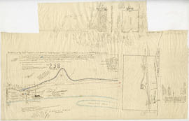
![McRoberts Island [Sea Island]](/uploads/r/null/6/9/6981a571c6d3102ee36ac270cce0eca9727531a3a9b4dd09f46f6f61adbbadbe/b8c696f2-5181-4f84-9e76-6420f9b2e916-Map800_142.jpg)
Part of City of Vancouver Archives technical and cartographic drawing collection
Item is a map of McRoberts Island (now named Sea Island). The map shows the locations of farms and the Vancouver Airport, notes on flora and geographical features, crops & dates/partitions of settlement.
Matthews, James Skitt, Major