
Preliminary map : Stikine River
- AM75-F26-: LEG1374.16
- Item
- 1929
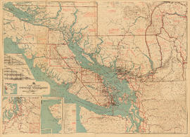
Item is a map of the Stikine River region from Dease Lake in the north to Stewart in the south. Map shows land and timber surveys, government and First Nations reserves, mining division and international boundaries, government agents' offices, mining and sub-mining recording offices, post offices, villages, Hudson's Bay Company posts, telegraph lines, hospitals, schools, radio stations, triangulation stations, railways, roadways, bridges, falls and rapids, glaciers, and topographic contours.


![[S.S. "Lady Alexandra"]](/uploads/r/null/7/4/e/74e87d22579d72c80b76610fb6a3083e0a77f35f8abf9edcf8901caa3937305e/0a29283e-c0ae-465f-b3c8-bc4c0e86379a-CVA374-95_142.jpg)
![[S.S. "Lady Alexandra"]](/uploads/r/null/6/2/9/629c61730ba93aebf4e46ce7d9fdd83f7f73f931af3af6cc8c7c545b559b05d4/39a64a9f-c6fa-4d04-a1b3-95333b270700-CVA374-93_142.jpg)
![[Steamer "Capilano" (II) - Port side view]](/uploads/r/null/2/2/8/22829c134e25cef621ec3100e8132514874c97508ba5f7a3e14313e19a887e4a/2e3d5137-f3a3-4c16-b517-1c89dfa5a5dc-CVA374-9_142.jpg)

![[Steamer "Capilano" (II) leaving Island Dock]](/uploads/r/null/d/1/d/d1d07abcb13b03d7727b8fd0ec6b91acd72ef0b1cc53cb9be31c217a48694a14/4d6f2231-8701-460c-a716-5f2fccec1feb-CVA374-7_142.jpg)
![[S.S. "Chilliwack" (II) at dock]](/uploads/r/null/2/6/f/26fbbe63d9ef32214d1a82f62eb3f47a4d3512f37f01fe1c6f5c586d8a7cbc22/fd5f1a0a-3397-4c7e-ad66-9d3e6b66080c-CVA374-56_142.jpg)
![[S.S. "Chilliwack (II) showing scows alongside transferring cargo]](/uploads/r/null/3/0/2/302f44c53fd8e47105f05e4c74dc895178fb7f72dd6d78c5eb4044ff493b1737/713524f8-1293-4ee0-b881-19f4c53330ca-CVA374-55_142.jpg)
![[View of unidentified bay showing a dock and a diving and slide float]](/uploads/r/null/0/a/9/0a9f98e9b8848d5a606e8e502c6355ccc86217c55b587b1cbf81a091b0e6aa4d/244ce391-de08-480f-8699-32e250875117-CVA374-488_142.jpg)
![[A couple sitting on a bench overlooking the water towards the mountains]](/uploads/r/null/0/9/c/09c1b281fbd6e4c13dd3fb4fa8f00e2d857691ecc6be74ff1f4b54a9b50bbc89/5014652c-ce2a-4550-9079-cbc042fa80c6-CVA374-485_142.jpg)

![[Second prize in Union Steamship's photo contest showing the S.S. "Camosun" at dock]](/uploads/r/null/b/3/2/b32c5d582297018de56afc341332672c5d5a69dc1dc9324e8708b8a955644f84/cb56a9e3-4e11-49b9-a284-8ef9f17eb477-CVA374-484_142.jpg)

![[View of unidentified resort area of Union Estates]](/uploads/r/null/2/e/0/2e03d30a9532a7b59f9a1bda0974b8db763508548579941882dfdb890041945c/79411a1f-303e-4bdb-af29-0eba3f6b9c08-CVA374-481_142.jpg)

![[S.S. "Chilcotin" on summer cruise service to north coast of B.C. and Alaska]](/uploads/r/null/7/e/2/7e2db9210f464ac3dadc0c92c787f2be94279772e1db8d40cbb4c64b3700e70a/71b70ec3-e01f-4b9b-913d-4ce061f2543d-CVA374-40_142.jpg)
![[S.S. "Chilcotin" on summer cruise service to north coast of B.C. and Alaska]](/uploads/r/null/4/3/d/43dad38fdba44b88b977f3f2d96b22fd4eebe82d331b9efcc6569a478db017cd/598c28f8-9a51-4e27-8e0f-115526272ac6-CVA374-39_142.jpg)
![[Howe Sound Ferries Ltd. Dispatcher's Office and Coffee Shop building at unidentified beach]](/uploads/r/null/0/d/1/0d1cc96cd976634087da4cedf8dcf4fce664751681e91f73b61b02fde6e094cb/7d85fce0-0a3d-47a0-be76-528890f58e0a-CVA374-362_142.jpg)
![[Union Steamship's] billboard](/uploads/r/null/8/6/b/86bd1218f0921362a4afcdcd41fdaa047932711c33aa8e84ab4a93a85ac97b7f/50a5be25-0716-417e-9f4e-7df68869167a-CVA374-313_142.jpg)
![[G. McBean and Capt. Henry (Harry) McLean and unidentified guests aboard S.S. "Chilcotin"]](/uploads/r/null/f/9/4/f94cccf3e300b946b80a004237502a924ee8905abcc5e0179f321f8888cd3836/203171b6-0068-4ccc-b039-bad1578b442b-CVA374-299_142.jpg)

![[Unidentified men at restaurant table]](/uploads/r/null/a/5/2/a5253fe25d61d5d3dfc4df1a41dfc20effe5c92b444a7dbf9e538a559e72a847/ae245b1f-9432-4609-a713-f81bb91c9bb7-CVA374-297_142.jpg)
![[Unidentified officer and passenger (possibly Mrs. Elsie Halterman) on deck of Union Steamer]](/uploads/r/null/0/9/d/09d1ed97a157d975937441fdb24ccf65064dc9f69b6a7f361330c7c47c30411e/b07d5bb1-8b7f-4e25-b744-2d1bf4c96f80-CVA374-295_142.jpg)
![[Gerald Rushton; J. Douglas Dingwall, Chief Ticket Agent; unidentified crewman; Capt. H.E. Lawrey]](/uploads/r/null/e/b/a/eba81127f24acb65e8b275527d2484a60e4bae35a7aa05f113aa9092b77d3daa/dadb9fe5-a022-4407-bc81-21c88025f659-CVA374-285_142.jpg)

![[S.S. "Cheam" at Resort Dock]](/uploads/r/null/5/7/b/57b1d60e98ee3eabbddd2201de8cf098398c8872ea64edae9e0733d673053847/848e8ccf-6fb2-4da0-9ad6-574f050119ba-CVA374-28_142.jpg)


![[Aboard] M.V. "Chilco"](/uploads/r/null/8/e/8/8e8bd812b877ffcdfe9a2968efe91f6e8455c2e36e7304550c4c82ed22b39aef/a5b724f6-d2d5-4224-bb46-9c3e8b27099c-CVA374-256_142.jpg)
![[Aboard M.V. "Chilco"]](/uploads/r/null/1/2/b/12bb4b0d9b0fb2176cda033ee131ba6fbe76c6c3efc323ceb53cf0cde624d15d/3105ffe8-778c-44da-8341-3c389b50439d-CVA374-255_142.jpg)
![[Aboard] M.V. "Chilco"](/uploads/r/null/f/c/6/fc6361dd879ee0a5f683283d98f29fb2f9d033431f8900f5d1b10cc8f44a3109/450cf325-3e5a-4c29-93e2-87d8957ca0de-CVA374-254_142.jpg)
![[Aboard] M.V. "Chilco"](/uploads/r/null/b/4/1/b41ffea81be40017ebbf0630b97995cf7f8b571be855e1ec641086b3ffc2736e/2060336d-6a5f-462d-8f00-934c99ee837f-CVA374-253_142.jpg)
![[Warship viewed from Coastal Steamer in] Queen Charlotte Strait B.C.](/uploads/r/null/d/1/a/d1a1232ec7f3649e597ad3c1110b0bbe7369aa213f8eedf71ee4c46d894741c2/bf0dddb3-0ed7-431a-9992-13dc39ec2e82-CVA374-246_142.jpg)
![[Floating village]](/uploads/r/null/3/4/6/346db92a826881787c29170756174220783e5796c1b2ed6ea90b9cfb7c31bbe6/d1cc1aac-5757-49f6-ba2d-427bc7d7a162-CVA374-245_142.jpg)
![[Floating village from a ship]](/uploads/r/null/b/d/d/bdd8b871ae47efbd8809e7d515330aa97593f31f39bf76bb48bffd6fd23a6cb8/70281e6e-4000-413e-96fb-96e82f0679f0-CVA374-244_142.jpg)
![Sedgewick [Sedgwick] Bay on Queen Charlottes [Haida Gwaii]](/uploads/r/null/5/3/2/53229f0668a0c0f8bb783d31ed1c5794cd6f7aa3c60d326ff43663954069ddc1/c7cd5a11-9eac-4a54-a66e-b9d649fa085c-CVA374-243_142.jpg)

![[S.S. "Catala"]](/uploads/r/null/e/0/8/e0899a4926c2c1bbbb673a97636414caddb85881ad685b762b0ef3606ab102aa/0bec7baa-b3cd-4246-aaee-59a26e52a2bd-CVA374-24_142.jpg)

![[View of] Portland Canal, B.C. [from aboard a ship]](/uploads/r/null/7/c/b/7cb9a03a807eac9f15c01627c267838d6417bc9dd5b5259d209d87212c3c0e61/40969840-20e1-419f-a176-eb4ece7b7e28-CVA374-232_142.jpg)