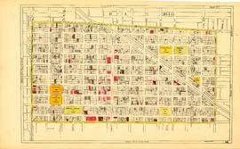
Sheet 7 : Clark Drive to Slocan Street and Seventh Avenue to Eighteenth Avenue
- AM1594-MAP 779-: MAP 779.09
- Item
- [ca. 1935]
Part of City of Vancouver Archives technical and cartographic drawing collection
Item is a section showing the area from Clark Drive to Slocan Street and Seventh Avenue to Eighteenth Avenue. Includes streets and roads, blocks, lots, legal descriptions, railways, parks and schools. Some annotations have been made in green ink.
Vancouver (B.C.). Office of the City Engineer