Sheet 21E [False Creek to Davie Street to Burrard Street to False Creek]
Sheet 22B [Cambie Street to False Creek to Oak Street to Broadway]
Sheet 24A [Cambie Street to King Edward Avenue to Oak Street to 33rd Avenue]
Sheet 24C [Cambie Street to 33rd Avenue to Oak Street to 41st Avenue]
Sheet 27A [False Creek to Ogden Avenue to Arbutus Street to 1st Avenue]
Sheet 27C [Granville Street to 1st Avenue to Arbutus Street to Broadway]
Sheet 29A [Granville Street to King Edward Avenue to Arbutus Street to 33rd Avenue]
Sheet 29D [Oak Street to 33rd Avenue to Granville Street to 41st Avenue]
Sheet 32A [Granville Street to 75th Avenue to Fraser River]
Sheet 32C [ca. Ash Street to SW Marine Drive to Oak Street to Fraser River]
Sheet 34A [Trafalgar Street to Broadway to Blenheim Street to 16th Avenue]
Sheet 34C [Trafalgar Street to 16th Avenue to Blenheim Street to King Edward Avenue]
Sheet 37D [Arbutus Street to SW Marine Drive to Yew Street to Fraser River]
Sheet 39A [Wallace Street to 10th Avenue to Discovery Street to 16th Avenue]
Sheet 40A [Wallace Street to King Edward Avenue to Univsity Endowment Lands to 33rd Avenue]
Sheet 40B [Blenheim Street to King Edward Avenue to Wallace Street to 33rd Avenue]
Sheet 40C [Wallace Street to 33rd Aenue to University Endowment Lands to 41st Avenue]
Sheet 43C [Blanca Street to 2nd Avenue to University Endowment Lands to 10th Avenue]
Sheet 44B [Discovery Street to 10th Avenue to Blanca Street to 16th Avenue]
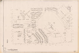
One way streets : illustrations of special intersections
One way streets : Illustrated map of Downtown Vancouver
Zoning Map: City of Vancouver, British Columbia
Existing service stations, retail shopping centres and commercial zoning : a basis for regulating location of service stations
Zoning Map: City of Vancouver, British Columbia
North-East Burnaby Study, revised Simon Fraser townsite plan : 1967 City of Vancouver alternative proposals
Official Regional Plan : proposed amendments within the City of Vancouver
Zoning Map: City of Vancouver, British Columbia
Map of City of Vancouver showing schools, parks, community centres, libraries, health units
Downtown peninsula - Vancouver, B.C. : contour lines at 10 foot intervals, datum line - 100
Vancouver low cost street program
Zoning Map: City of Vancouver, British Columbia
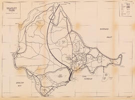
Stanley Park
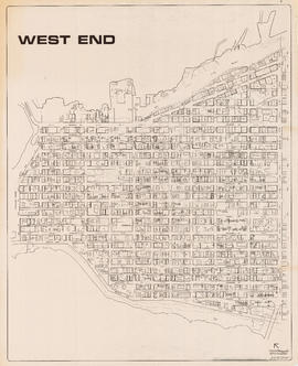
West End
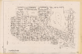
West End local area
Zoning District Plan : City of Vancouver, British Columbia
Sectional map of Vancouver showing streets, block and lot outlines, and building perimeters : Map 11 : Nanaimo Street to Rupert Street and Burrard Inlet to McGill Street
Sectional map of Vancouver showing streets, block and lot outlines, and building perimeters : Map 13 : Rupert Street to Boundary Road and Burrard Inlet to Eton Street
Sectional map of Vancouver showing streets, block and lot outlines, and building perimeters : Map 14 : Cassiar Street to Boundary Road and Eton Street to Pender Street
Sectional map of Vancouver showing streets, block and lot outlines, and building perimeters : Map 19 : Clark Drive to Nanaimo Street and Frances Street/Ferndale Street to 2nd Avenue
Sectional map of Vancouver showing streets, block and lot outlines, and building perimeters : Map 33 : Clark Drive to Nanaimo Street and 2nd Avenue to 13th Avenue
Sectional map of Vancouver showing streets, block and lot outlines, and building perimeters : Map 40 : Inverness Street to Nanaimo Street and 13th Avenue to 22nd Avenue/24th Avenue
Sectional map of Vancouver showing streets, block and lot outlines, and building perimeters : Map 42 : Oak Street to Ontario Street and 16th Avenue to 28th Avenue
Sectional map of Vancouver showing streets, block and lot outlines, and building perimeters : Map 43 : East Boulevard to Oak Street and 14th Avenue to Laurier Avenue
Sectional map of Vancouver showing streets, block and lot outlines, and building perimeters : Map 46 : Blanca Street to Discovery Street and 14th Avenue to 16th Avenue
Sectional map of Vancouver showing streets, block and lot outlines, and building perimeters : Map 49 : Arbutus Street to Oak Street and Laurier Avenue to 33rd Avenue
Sectional map of Vancouver showing streets, block and lot outlines, and building perimeters : Map 50 : Oak Street to Ontario Street and 28th Avenue to 37th Avenue
Sectional map of Vancouver showing streets, block and lot outlines, and building perimeters : Map 58 : Inverness Street to Berkley Street/Nanaimo Street and 41st Avenue to 49th Avenue
Sectional map of Vancouver showing streets, block and lot outlines, and building perimeters : Map 67 : Musqueam Indian Reserve and Shaughnessy Golf Course
Sectional map of Vancouver showing streets, block and lot outlines, and building perimeters : Map 69 : Wallace Street to MacDonald Street and 49th Avenue to the North Arm of the Fraser River
Sectional map of Vancouver showing streets, block and lot outlines, and building perimeters : Map 73 : Quebec Street to Inverness Street and 47th Avenue to 57th Avenue
![Sheet 21E [False Creek to Davie Street to Burrard Street to False Creek]](/uploads/r/null/a/1/7/a17df28dc74a3289130d69e3127d8359db8fcb6874b93ae297e2adc3d8bc5908/a7593e2c-69d3-40db-adf4-14f466daa20d-LEG1153_142.jpg)
![Sheet 22B [Cambie Street to False Creek to Oak Street to Broadway]](/uploads/r/null/4/7/0/470f0042fcb173650c5e639f6a3e1fa5ab172d8c24414a73f1f39b1c7f9a33da/e4debb90-fa37-4222-8c9d-8024425d27f1-LEG1153_142.jpg)
![Sheet 24A [Cambie Street to King Edward Avenue to Oak Street to 33rd Avenue]](/uploads/r/null/4/d/f/4df334f2a1b28196a8dfbda111ca8ee5191e7b09999d0256eeaf2c86b4daa71b/4a5d7f32-99b6-4a0d-9357-04f2b3acd7e1-LEG1153_142.jpg)
![Sheet 24C [Cambie Street to 33rd Avenue to Oak Street to 41st Avenue]](/uploads/r/null/d/f/b/dfbe75de645e78395a8dd3c5755b0726d5fc09d3223cce80293adbe699f67d42/84082c16-9757-4782-bf71-f11675bc62af-LEG1153_142.jpg)
![Sheet 27A [False Creek to Ogden Avenue to Arbutus Street to 1st Avenue]](/uploads/r/null/d/d/e/dde9895d9295b400018d638c5546cafa95a45a7ca43b82ce58746db6c9ff0af2/dcf58974-c0f9-4da8-b6fb-0154ea30160b-LEG1153_142.jpg)
![Sheet 27C [Granville Street to 1st Avenue to Arbutus Street to Broadway]](/uploads/r/null/9/2/f/92f0935ee4ee12444aa52d59fffd2ce736419ce7061cf776d4aa8c330764c5d9/45b3a507-1ee7-420d-930e-5a9b1a562152-LEG1153_142.jpg)
![Sheet 29A [Granville Street to King Edward Avenue to Arbutus Street to 33rd Avenue]](/uploads/r/null/0/2/0/020c3cd95d6239e63b827986897bce758e46a70dc2230826ce96b52d664b45bc/b7b6547f-3a3d-4549-b127-e526caf2fd26-LEG1153_142.jpg)
![Sheet 29D [Oak Street to 33rd Avenue to Granville Street to 41st Avenue]](/uploads/r/null/9/2/e/92eb5089faaa658573632f3a36672d4fae768876ceccc53c3a3d9e05dbe2065d/f633505f-f0ba-444b-8fba-57a4f512c2bc-LEG1153_142.jpg)
![Sheet 32A [Granville Street to 75th Avenue to Fraser River]](/uploads/r/null/5/6/d/56dd001a6068ff019e8c162635cb6480bcd925462ba8cf645e2b74ba80231183/fa992939-a286-43c0-93fa-53a5ddc2fb5a-LEG1153_142.jpg)
![Sheet 32C [ca. Ash Street to SW Marine Drive to Oak Street to Fraser River]](/uploads/r/null/c/0/5/c05f6e83dc753e09f750ae31402aff071dcb62932c884f4790c57d007b2e518b/e996ae22-ddc0-40b2-afcc-6296eeff5a1c-LEG1153_142.jpg)
![Sheet 34A [Trafalgar Street to Broadway to Blenheim Street to 16th Avenue]](/uploads/r/null/a/6/8/a68d936e7b5e926d428aee3fe4668c1a125dfe87df3299de573f49901a9bfcc8/e6c00fa0-813d-4a58-9f00-5152b45ef16c-LEG1153_142.jpg)
![Sheet 34C [Trafalgar Street to 16th Avenue to Blenheim Street to King Edward Avenue]](/uploads/r/null/3/c/e/3ceea778d5a7602e603e5528548ba509862b53454d5d5cef9605f026939a877f/27939355-1f35-4c7c-a59e-c5da77c34f3f-LEG1153_142.jpg)
![Sheet 37D [Arbutus Street to SW Marine Drive to Yew Street to Fraser River]](/uploads/r/null/e/5/a/e5aa2aae86553141e6823eeb67fd0bb9703daffd5797730546a140a6385f3969/3923280b-492e-4b85-8046-96702ef629fa-LEG1153_142.jpg)
![Sheet 39A [Wallace Street to 10th Avenue to Discovery Street to 16th Avenue]](/uploads/r/null/d/e/6/de6660a119a0cdd1d10c1297f2cf1c2b4552e9ddec3edf92644013f9cc15e2e1/07059a40-a2f4-4334-9056-d62c618151ec-LEG1153_142.jpg)
![Sheet 40A [Wallace Street to King Edward Avenue to Univsity Endowment Lands to 33rd Avenue]](/uploads/r/null/f/1/f/f1fd90433a6a288ac0a5c1cf28ccdf3020b21d50e9ccff5ce6c7f752a26ab030/c53b5933-6833-4457-8b54-75aa04b81180-LEG1153_142.jpg)
![Sheet 40B [Blenheim Street to King Edward Avenue to Wallace Street to 33rd Avenue]](/uploads/r/null/a/d/0/ad02d0ef5c1b93f161c46247cc4614b2d56e9cd6a9ff6160d8287e89942f9956/9dd41d25-161b-4003-854d-d02e9a9898ff-LEG1153_142.jpg)
![Sheet 40C [Wallace Street to 33rd Aenue to University Endowment Lands to 41st Avenue]](/uploads/r/null/8/5/6/856a4a832f68fa55c97dfecc6eed8ea78f09e3a96b2c14401b6340f61ae6fff8/85d634e1-5e30-45cf-a659-80c3efa9bf27-LEG1153_142.jpg)
![Sheet 43C [Blanca Street to 2nd Avenue to University Endowment Lands to 10th Avenue]](/uploads/r/null/8/e/a/8ea10dc3c6492327a5e0addd9018cab3617de431e837beda4233bb94d8c2db98/d339ad6e-552a-4c6c-a353-a547405cbf57-LEG1153_142.jpg)
![Sheet 44B [Discovery Street to 10th Avenue to Blanca Street to 16th Avenue]](/uploads/r/null/0/f/7/0f7db59d1a90e970d1a27d525155c52735957e90e75e1142b86be956483805d9/ff72da6d-d789-4ce6-9b3d-9361505882c7-LEG1153_142.jpg)