Narrow your results by:
- All
- Major Matthews collection, 146 results
- City of Vancouver Archives technical and cartographic drawing collection, 146 results
- City of Vancouver Archives pamphlet collection, 108 results
- William Orson Banfield fonds, 84 results
- City of Vancouver fonds, 45 results
- H.A. Price collection, 30 results
- Elizabeth Abbott fonds, 25 results
- City of Vancouver Archives photograph collection, 21 results
- James Crookall fonds, 18 results
- Richard H. Trueman fonds, 18 results
- All
- Vancouver (B.C.). Engineering Services, 33 results
- Canadian Pacific Railway Company, 28 results
- Caple, Norman, 27 results
- Trueman, Richard Henry, 20 results
- Crookall, James, 18 results
- Edwards Bros., 18 results
- Coltman, Don, 18 results
- British Columbia Electric Railway Company, 17 results
- Thomson, Stuart, 15 results
- Moore, W.J., 14 results
- All
- Vancouver (B.C.), 270 results
- British Columbia, 98 results
- Okanagan Valley (B.C.), 34 results
- Fraser Valley (B.C.), 18 results
- New Westminster (B.C.), 12 results
- Lower Mainland (B.C.), 11 results
- Greater Vancouver (B.C.), 9 results
- Ontario, 8 results
- Yale (B.C.), 8 results
- North Vancouver (B.C.), 6 results

![[Port Moody]](/uploads/r/null/a/8/a8c2664076fa4f8ab2a409e5240e4c3740d6914e3a818ac8eac7fe948c783c78/5ef8253e-c9e1-4601-a3c7-4334aee88684-A26772_142.jpg)


![[Lord Strathcona driving the last C.P.R. spike]](/uploads/r/null/b/a/ba70f425a54f07cfb3d7961026759656a9bed0bfaeec2735cb7465d83231b9ba/edb174b3-d28f-427b-bfe9-44c62d264b86-A25410_142.jpg)

![The Quoi EK cuttings, 55' deep [excavation for the C.P.R. track]](/uploads/r/null/8/b/8bd32af0d9861d5f0fc06cfd06a0ef3104546d01229f7684ce572db66a75a032/86b1723f-a729-47d5-94cd-14fed959d258-A25457_142.jpg)


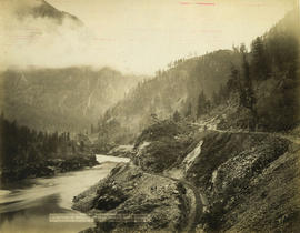
![[Spences Bridge]](/uploads/r/null/1/2/12d6cf4fc043911bb5bfefbb066d9923d9a35c4baa8a64a47e1b676cf75f39cb/54798946-2f64-4712-a1d4-15dbcc417df3-A33617_142.jpg)


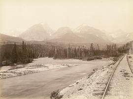
![Sailor Bar Bluff [in the Fraser Canyon]](/uploads/r/null/2/7/2756008117b1cacdfb661cb8721f6127b3ca3fdd00971d10488cb41fa0368b12/ec0f6a17-6a63-4e3f-8ad3-397813c040fa-A19747_142.jpg)
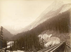
![Devil's Gap [and] Beaver Canyon View No. 2](/uploads/r/null/4/4/44d0528e595370f28fc2340079698113fd07efcd4c94dca50739bca01fccf576/c7c99282-4843-4adf-822c-539477e63eb9-A19771_142.jpg)
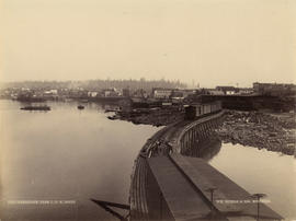
![Terminus C.P.Ry. [at the foot of Trafalgar Street]](/uploads/r/null/b/d/bdca25e8efa0170ebff8d0becc4e261a7d6f2334ff4033d4c5ed25f41f1dcf05/1d7cb71b-b48b-497d-942b-9797b845377e-A25525_142.jpg)
![[View of Yale]](/uploads/r/null/7/7/7724c2b4e06d4db5f718f25822187a7181780f3cb38db4f0664ba99d31bce97e/e1063711-2204-4f0c-9ddf-c0112749d852-A33756_142.jpg)
![[Hastings Sawmill from the foot of Gore Avenue]](/uploads/r/null/8/1/8111f3b1d80da8d446ff81e5ff56c73a6d8e61542c49217cb6bf2b3c0c584f0d/9b8992fb-e01a-41c6-9fb7-be009f4a983a-A32549_142.jpg)


![[Capilano Creek waterworks]](/uploads/r/null/7/7/77575f1809735b16a9944f412163f98f596dd55ac925f50b13267002dfa3ffb8/232096c5-a1aa-4f89-8724-7825d09e71e0-A25800_142.jpg)


![Sandon, B.C. [showing railway lines]](/uploads/r/null/4/8/6/48639236b7c253b9ab2075ad1fadf01cbd0409f352287f6c26f306752ed36433/73d32b98-8f7e-4f27-afcb-f4dd34dccffc-CVA256-02_142.jpg)

![[Team of oxen pulling logs]](/uploads/r/null/a/2/a205131bc534250a03a25466b00770104f08d8cf933a9dabeb76385789209eb6/f3eefbe7-65ac-4ecb-8e8c-d21ee153faba-A09226_142.jpg)


![Kamloops, B.C. on C.P.R. [route]](/uploads/r/null/e/a/0/ea0443d7d78dee9c88ac6c16f93423611f318782a8cdc5b427c7748e0062d430/4dfe9e24-91b0-444f-b492-414c4529344e-CVA256-02_142.jpg)
