Downtown Eastside walking tour : Vancouver's oldest historic district
- PUB-: 2014-047.1
- Item
- 2006
Part of City publications collection
Vancouver (B.C.). Community Services
6250 results with digital objects Show results with digital objects
Downtown Eastside walking tour : Vancouver's oldest historic district
Part of City publications collection
Vancouver (B.C.). Community Services
Aerial view of Vancouver looking south east
Item is a photograph showing downtown Vancouver with BC Place Stadium and Science World in the foreground and the Burnaby skyline in the background.
Harbour Green Neighborhood; Hastings Street Elevation North
Part of City of Vancouver Archives technical and cartographic drawing collection
Item consists of a street elevation of Hastings Street between Bute and Jervis streets, most likely depicting the proposed Evergreen Building at 1285 West Pender Street.
Site plan of central downtown waterfront
Part of City of Vancouver Archives technical and cartographic drawing collection
Item is a map of the central downtown waterfront area, from the eastern end of Coal Harbour to east of Crab Park, depicting roads and buildings. The drawing may be related to 2014-002.04.
[Pacific Stage Lines bus station during tear down]
Item is a photograph showing parts of the former bus company building at Larwill Park along Dunsmuir Street.
[Pacific Stage Lines bus station during tear down]
Item is a photograph showing parts of the former bus company building at Larwill Park along Dunsmuir Street.
[Pacific Stage Lines bus station during tear down]
Item is a photograph showing parts of the former bus company building at Larwill Park along Dunsmuir Street.
Site plan of central downtown waterfront
Part of City of Vancouver Archives technical and cartographic drawing collection
Item consists of a site plan that appears to depict a proposed redevelopment of Seabus terminal site for second cruise ship terminal and new helijet terminal to the east. The plan also includes a pencil sketch of the profile of the proposed building in the margins of the site plan.

Vancouver downtown property map
Part of City of Vancouver Archives technical and cartographic drawing collection
Item consists of a planning map depicting every building between Main Street and Stanley Park north of False Creek, showing the address, name (if a commercial building), number of floors, and type of use (commercial, apartments, vacant, etc. ). The map may be based on a City of Vancouver Planning Department map, partially re-purposed and published by Colliers Macaulay Nicholls.
Marathon Realty Company Limited Coal Harbour Redevelopment
Part of City of Vancouver Archives technical and cartographic drawing collection
Item consists of a site plan map delineating the outline of what appears to be a proposed redevelopment of the western portion of Coal Harbour. The site plan uses as a base map an aerial photo of the waterfront from Coal Harbour to the convention centre.
Item is a schedule of special events and entertainment downtown.

Demonstration in front of Law Courts building : I'm a good lesbian mum
Part of BC Gay and Lesbian Archives
Demonstration in front of Law Courts building : I come from a normal stable home
Part of BC Gay and Lesbian Archives

Demonstration in front of Law Courts building : I am a natural dad
Part of BC Gay and Lesbian Archives
![Demonstration in front of Law Courts building : [Paul Crowel]](/uploads/r/null/1/f/0/1f01635027b9ee7fcecf0759163eb0b6980c643652b8a07e0f6dae2b9ba27391/1527f76a-93cb-44e8-ae7f-8b90c2eb45b7-2018-020_142.jpg)
Demonstration in front of Law Courts building : [Paul Crowel]
Part of BC Gay and Lesbian Archives

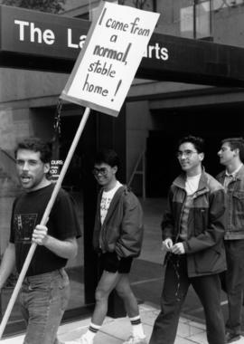
Demonstration in front of Law Courts building : I come from a normal stable home
Part of BC Gay and Lesbian Archives

Demonstration in front of Law Courts building
Part of BC Gay and Lesbian Archives
Downtown Peninsula; Vancouver, B.C. Canada; Lines at 100 Foot Intervals; Datum Line 100
Part of City of Vancouver Archives technical and cartographic drawing collection
Item consists of map of downtown Vancouver (possibly using a Planning Department map as a base map) depicting hand-drawn topographic countour lines, possibly created as part of a development application.

Demonstration in front of Law Courts building : I am a natural mom
Part of BC Gay and Lesbian Archives

Demonstration in front of Law Courts building
Part of BC Gay and Lesbian Archives

Demonstration in front of Law Courts building
Part of BC Gay and Lesbian Archives

Demonstration in front of Law Courts building
Part of BC Gay and Lesbian Archives
![RLS [Downtown street]](/uploads/r/null/b/9/a/b9a32227c48425cefdcc288cbf37aa631d3e9bc5d968de7d113f57551211d83d/737fe8d1-c17e-4eb2-86b2-24ed62bfe701-2019-103.0060_142.jpg)
Part of City of Vancouver fonds
![Untitled [967 of 991]](/uploads/r/null/1/a/1ac1c953383038a17662668715ca471757e2f3f8dc4ca9cf3d1f7f143074f096/4e31420e-3576-4e57-9bf3-580dd3852f66-A69377_142.jpg)
Part of City of Vancouver fonds
Item is a photograph showing a street view of the Rogers Building (470 Granville Street).
![Untitled [968 of 991]](/uploads/r/null/c/d/cda7470443c0037d59da9261021f7964e8c40d8026f16be63ef77e81e29cb5d1/b764cbd4-831d-4e59-8e3a-51d3c51e737d-A69378_142.jpg)
Part of City of Vancouver fonds
Item is a photograph showing a view of Cambie Street, between Cordova and Water Streets with the steam clock on Water Street in the background.
![Untitled [471 of 991]](/uploads/r/null/b/1/b13ba1d1f337d9e2d2f170cf3ecb1ec6a87498c4becb94f477d4662715c52e1f/4afe3b00-f3a4-46ca-931d-04f9aa60c176-A68437_142.jpg)
Part of City of Vancouver fonds
Item is a photograph showing the skytrain tracks at Waterfront station.
View of the beach at English Bay with the apartment buildings along Morton Avenue in the background
View of corner at Morton Avenue and Denman
View of the apartment building at 1835 Morton Avenue from Morton Park
View of street along Morton Avenue from the beach at English Bay
Item is a photograph showing the apartment building at 1835 Morton Avenue
View of English Bay at sunset [taken from an apartment at 1835 Morton Avenue?]
Item is a photograph showing part of Morton Park and the beach at English bay with several tanker ships in the distance.

Development site at 1095 West Pender Street
Part of City of Vancouver fonds
Development site beside building at 1111 West Hastings
Part of City of Vancouver fonds

Group standing on corner of Hamilton and West Georgia Streets
Part of City of Vancouver fonds

Queen Elizabeth Theatre Bank of Montreal signboard
Part of City of Vancouver fonds

Queen Elizabeth Theatre Bank of Montreal signboard
Part of City of Vancouver fonds
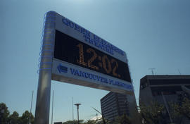
Queen Elizabeth Theatre Bank of Montreal signboard
Part of City of Vancouver fonds

Portal Park with view of North Shore
Part of City of Vancouver fonds

Portal Park with view of North Shore
Part of City of Vancouver fonds

Portal park during construction
Part of City of Vancouver fonds

View of Canada Place and Downtown Vancouver
Part of City of Vancouver fonds

Vancouver skyline from Coal Harbour
Part of City of Vancouver fonds

Vancouver skyline from Coal Harbour
Part of City of Vancouver fonds

Vancouver skyline from Coal Harbour
Part of City of Vancouver fonds

Part of City of Vancouver Archives technical and cartographic drawing collection
Item consists of a large scale site plan, depicting a proposed development in False Creek [Expo 86?] annotated on top of what appears to be a City planning map. The plan appears to depict part of the Concord Pacific development.

Group standing on corner of Hamilton and West Georgia Streets
Part of City of Vancouver fonds

Part of City of Vancouver fonds

Part of City of Vancouver fonds