
Map of portion New Westminster District
- AM1594-: MAP 1055.02
- Item
- 1877 (copied 1954)
Part of City of Vancouver Archives technical and cartographic drawing collection
Item is a heavily-amended copy of a map illustrating intended land settlement and subdivision in 1877 in the future sites of Vancouver, Burnaby and the North Shore, from an area bordering on English Bay to an area bordering on North Arm. Also shown are bodies of water, Hastings & Granville Road, and the settlements of Hastings and Granville. Annotations by J.S. Matthews in 1954 made on the copy are tracings in white pen and darkening the background to improve the copy.


![[Looking east towards Prospect Point]](/uploads/r/null/3/5/353b1aa08c35d1d8b5089e30dbf1e7cbd7be47afb7288ca95f34e01df15f3530/0799ffa0-869e-459b-8fdc-d783d59aef7c-A49523_142.jpg)
![[Exterior of first house at Caulfield]](/uploads/r/null/f/4/f41bfbbab0339cffd2a93f1f3b9486b2d4b89ed1fa383d507e1fd33717bb90a4/76cdc763-c9e3-43c5-b079-78e3e132b4d6-A26850_142.jpg)
![[Point Atkinson lighthouse]](/uploads/r/null/1/a/1a241f9651c7227ddbcd480f5461ba287b303d0ccf1b7f615a3f684830a07c4b/24e03d92-cf23-4679-9959-695aae157f07-A26944_142.jpg)
![[Rear of the first house in Caulfield]](/uploads/r/null/4/e/4e171ad1226e76ca932a20a4c52bc24045ed91f5722c3c72a10eb5a969663106/2af300c8-6327-41e9-81d5-217727b56d5c-A26845_142.jpg)
![[Exterior of first house at Caulfield]](/uploads/r/null/b/e/bef25ec1e63888210861447f40dc01d26cbf5a76db9957d177c541170fa35300/bc29b75b-dcb2-40d7-b011-49a23206663b-A26851_142.jpg)
![[The wedding party of Mr. and Mrs. W.D. Hopcraft at Skunk Cove]](/uploads/r/null/3/5/35591ceca5b28bebd498fbb5932bcda78cd9a5da9fd339874c20603c1eab02c0/38555d34-ff27-4564-b0f6-15bea5926c30-A35717_142.jpg)
![[A picnic near the Capilano River]](/uploads/r/null/9/3/9333930096881c698809da1ef83bf995c5aa875904b88bb626be4584193e5d3a/e91e592d-d88b-4813-86d0-887cc41508dd-A62961_142.jpg)

![[John Innes and his nephew]](/uploads/r/null/f/f/ff33025b6cd0e947da62214fa57f61343479a220b9206aedf68e4da1497067ae/f681be3f-d469-43cb-8584-823581436c3c-A35561_142.jpg)
![[John Lawson]](/uploads/r/null/3/0/307a721243090eb5783ceb9712ecda97d23380b3dc1f53a9a2cda855718eee3d/48c535ef-8e79-445f-9e85-6960903a75a3-A34424_142.jpg)

![Point Atkinson [lighthouse]](/uploads/r/null/d/0/d0e16933532d5ba35ae7031212691a3532440f71199c4829d8295ddb1edc4a54/8e05cd24-7da0-458c-9f99-8716817d4e61-A02296_142.jpg)
![[The wedding party of Miss Elizabeth C. Lawson and Mr. W.J. Pitman]](/uploads/r/null/f/b/fb3aef4f232e343375ea1d41bcbcc19c7d4be079d890401633abe20a08e98352/9bdd17b0-8e87-4a9e-b776-07b118bf425a-A26829_142.jpg)
![Clearing on the Marine Drive [at] Hollyburn West Vancouver](/uploads/r/null/8/9/8909034c58129aab3d83749957c381275aedf9d529ca72d94e31853f6c91fb6d/bc61caec-280a-4abd-a9bf-da3e6fb175b4-A26827_142.jpg)
![[Mrs. Henry Roome McDonald]](/uploads/r/null/d/7/d7cfd1a6796a1628f7b781aa49df76830fa8ca73799e7fda12c9c572fcfb2d3c/89dd4fd0-2945-40c7-a217-904a4f41d48d-A61944_142.jpg)
![[Mr. and Mrs. Fred Rogers and their daughter Mina camping at Point Atkinson]](/uploads/r/null/1/0/107a12383288d11c1809d4c47b62a829b510a616c149f6c66df931677b858758/cea37e6a-ed39-4dc9-a566-c9e6ceeed5ff-A62063_142.jpg)
![[The wedding party of John Lawson's daughter outside Navvy Jack's house]](/uploads/r/null/8/2/82c0b2c341033e2b72f7d96d8a773c07b0e3eb8396736a85ee23d0dd969cfa00/d15396d8-bd47-4d09-a238-6b950dd67e20-A26822_142.jpg)

![[The second Point Atkinson Lighthouse]](/uploads/r/null/b/9/b9e177ee1ce9f57b4511f889b52cdc17371e5c62bd8436b25100c835f3ff9f3b/ebb69d73-121f-4ef6-a07e-0f59ccc800db-A33178_142.jpg)
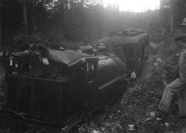
![McNair Fraser logging camp [at] Hollyburn](/uploads/r/null/6/1/6127900d60495b36275d2030b34833c0def918d3be9decbb28759fee910cb52e/d4084822-050b-4a5a-9c65-a7966aa8799d-A32031_142.jpg)
![McNair Fraser logging camp [at] Hollyburn](/uploads/r/null/4/3/438cb9f3ea9ffba41568e3e2b27fcc09e3edc5e1ce64634bd8622bb56e1b6c35/1ae97068-fc03-444d-b48f-f4d8a9a5c325-A32033_142.jpg)
![McNair Fraser logging camp [at] Hollyburn](/uploads/r/null/9/5/9504fc2db10f851a409b0fded43f3e4434d228862b93ccb189f03c60fd2a9fce/43afe828-9389-4e86-b2c2-146d337bd4c0-A32034_142.jpg)

![McNair Fraser logging camp [at] Hollyburn](/uploads/r/null/d/f/df98bb47791ed76d78beee034253482dcb66148b28f352e3289d25a185769866/660f484b-cba6-45fa-a4ef-cb33fa46a1d2-A32000_142.jpg)
![McNair Fraser logging camp [at] Hollyburn](/uploads/r/null/9/6/96f318e3c66fe037dbd471ce8683420a317a3e095ee637731af77c685232395c/cbfa4cb6-3e4e-45ed-9783-d31ebed73692-A32032_142.jpg)
![McNair Fraser logging camp [at] Hollyburn](/uploads/r/null/1/7/17c669b5ffa8e697789ca2d41a25676250c3548ba8c425892509d5b2d825c0a1/3807a641-f32e-4e62-9614-a499d8116603-A32035_142.jpg)
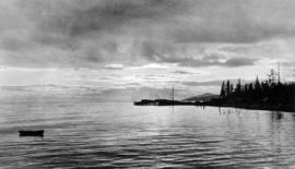
![[View of Howe Sound from West Vancouver]](/uploads/r/null/6/4/649341c49f83c72c9ccc5752e4c240ed18f92e388317fd2b92d6ea158284ac0e/b8fa4789-0f52-40e6-9c28-3e7d116bf973-A36138_142.jpg)
![Chas [Charles] Nelson Reeve 1912](/uploads/r/null/6/1/6141998a6e70e75c3c11db1b09bff968dd4668e1cb32ae457707e154d8e9d421/82bbcfdf-853b-4a46-bc4d-a3d427f7b033-A35780_142.jpg)


![[Point Atkinson lighthouse]](/uploads/r/null/f/5/f508b4c86166edb5ce8fc619cb3b583115a9beee6de98ea2826865034da83342/10b29b7c-c514-41cd-99a7-af14b6fc65aa-A33424_142.jpg)
![Mother [Harriet Banfield] and Auntie Bessie at Mr. Henshaws home at Caulfields](/uploads/r/null/6/8/0/680578d4ffed908c428e5f62260d46e56fa23ccec750b9b59a5d0d582ab8cdf4/42595932-1b30-4d5e-8e18-565bc0fc35ea-CVA289-002_142.jpg)

![Mae [Nickson] pensive](/uploads/r/null/9/1/9/919aa606a6b9c6a280067e3185625c4feb1ba1cce305100319e86fc8d55a7576/aac4fa4d-9b47-40a2-b1cc-907dca6f7bef-CVA289-002_142.jpg)
![Mae and Ralph [Nickson]](/uploads/r/null/6/6/9/669a7d7deb9330f7c58e9e331d8379d3837bc981cec65ab6e9a5ea2db8ccca9a/890ed465-9809-4cf5-9beb-c1020dc16160-CVA289-002_142.jpg)
![Mae [Nickson]](/uploads/r/null/6/6/f/66f46a665ee24bc8352c2192c7605dfdfc072c1e419ab0e399c26e1f14a6b067/06e3d83d-efff-452a-bfb4-b34f7b617679-CVA289-002_142.jpg)
![Mae [Nickson] on Cypress Creek](/uploads/r/null/7/1/c/71c29b8c7cab0d107c00cd4fe148de171f3a7d20cf26eefff60f344c219b1be4/3c94e7b8-6d82-411e-968e-e039c50a83ad-CVA289-002_142.jpg)
![Mae [Nickson] and Lois [and two men]](/uploads/r/null/c/c/2/cc21217347899a234f326138d5ef7cb179cb19f1ca1433a06e96a20ba40cb2ee/fc756ed3-42b7-4a11-ac72-45106731e6a4-CVA289-002_142.jpg)
