
- AM1535-S1-: CVA 1123-4
- Item
- May 27, 1919
Part of Stuart Thomson fonds
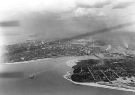
Oblique view looking east along Broadway showing Kitsilano, the B.C.E.R. Lulu Island line, and the Kitsilano Trestle and Granville Bridges, Granville Island, Fairview, Downtown and Yaletown in the background


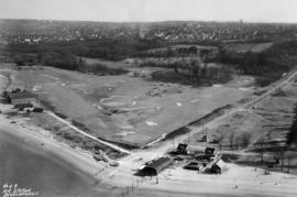
![Race Track - [Hastings] Park](/uploads/r/null/a/e/ae3866984dbd71adb11e4f16a3faeff5c926d7d6dbc7c68bef37bbe9e34f2147/8e72031a-2c43-4d2f-ade2-eaf99cf53105-A44678_142.jpg)


![Grain Elevators and dock - foot of [Commercial] Drive looking east](/uploads/r/null/f/a/fa64fc2fdcd81147912c6227ac42be08f398a362ba801186b73930b6b55d9888/5fb3ff66-892d-4cce-b810-d6918a9c1aed-A44690_142.jpg)
![[View of Vancouver Waterfront showing Union Dock]](/uploads/r/null/c/e/e/cee95cbf9aaa5e1575599f13a63661f6af1be660e92b8121f91e9cf4da242d14/bfb01bf2-4ce4-4ce5-a8d2-6b7244d5e1df-CVA374-146_142.jpg)
![Aerial view [of Coal Harbour] taken about 1924](/uploads/r/null/b/b/d/bbdc60cbd22ccc304389718ccb2f6a0ca5a1fa849f7ae6fcb7a5e340b38d6240/0f7878e2-d7fb-45db-bcb7-18acde1d4105-CVA66-07_142.jpg)
![[Aerial view looking east over Stanley Park, Coal Harbour and Burrard Inlet]](/uploads/r/null/d/0/d02fee694c486ac2accdeefb505d0dae5fcb42789ef16de49322d845e3c04b44/be8c34ce-7c09-4c0e-a395-f083c9134080-A43248_142.jpg)
![[View of Vancouver waterfront showing Union Dock]](/uploads/r/null/d/d/7/dd7ab36410c42b9534434120e65592352742facf102963e83e7d56a08e4dd00e/88ad4685-0b94-4bb5-801e-318dd133e0f9-CVA374-145_142.jpg)
![[Aerial view looking north over Downtown]](/uploads/r/null/4/b/4b54e616319b32d55e40e5c7404b5eccbd9b053f144a101245a1e709d1cfd4d2/1752a263-31cd-4155-880a-ead0fa54c115-A43250_142.jpg)
![[Aerial view looking north from False Creek]](/uploads/r/null/0/8/081746026b1559c2ace13027d77c668cba79e15800d0ca6ca466b205529e45b3/ce072490-3b01-4b65-8d61-bfaa102cca83-A43247_142.jpg)
![[Aerial view looking east towards the Second Narrows (Iron Workers Memorial) Bridge]](/uploads/r/null/a/3/a30e769b11d82234857ac24837baf510f2440359b92782f8e65bf107d5c50ffe/d0897c6d-49e8-4e61-b76c-6f04433a9e5b-A43252_142.jpg)
![[Aerial view of West End and Stanley Park]](/uploads/r/null/4/d/4/4d4e724e2a486490856fe60b67dfeee43429a3860f0dd9901058a9e86f640a07/120e79a6-7374-40bd-b57b-8eaac78f191c-CVA374-180_142.jpg)
![[Aerial view looking northwest of the West End and Stanley Park]](/uploads/r/null/8/8/7/887dd5ff7e349fb28124477bf87837887e09eb02be29444c2ab484fb9068ab51/a90b562e-ef47-480e-b13c-5cb26250e139-CVA374-181_142.jpg)
![[Aerial view of the CPR Piers "A", "B", & "C"]](/uploads/r/null/c/c/cc83a61bf28d479ee3b43f6f9f31d016a88270965414162937f15e136455615f/64b8af34-6e81-4bd2-a0e1-5923c6b420ec-A49477_142.jpg)


![[Aerial photograph of the third CPR station]](/uploads/r/null/9/3/9363f69f5bfb9481d61b35900379670ba15b8e772331e9caa6991d35c9d56ba4/d6afd168-9017-4907-98a1-0d62f437998c-A49478_142.jpg)
![[Aerial view of Kitsilano Beach]](/uploads/r/null/0/4/04933fd0b52b1825a12ac427f70fb35dc469232064c8156168d851093d1ae411/05361ecf-adfc-4cdc-be95-07157d2e9dd1-A23610_142.jpg)

![[Aerial view of J.F. Malkin's residence at 1950 Southwest Marine Drive]](/uploads/r/null/e/8/e8b684b06c9e0631c4a425d2b9bcd1376874c91eef26e2a789fe69d080c32f4c/ed047908-3466-488c-9dc3-536dcb876908-A62676_142.jpg)
![[Aerial view of Vancouver looking south from Burrard Inlet]](/uploads/r/null/d/1/d168ad5e5af96082c1c6fe04b81895efc9e0f4c037952a04c6f572cc62674f1d/899c29bd-d99f-4ae7-b246-caf98b4806c1-A49667_142.jpg)
![[Aerial view of C.P.R. Pier D at foot of Granville Street and part of Pier B-C]](/uploads/r/null/1/2/1279166be0c0e3fb49d7f4d3b69a946f9d333b81011634e471cffa6693a2e4ea/321b8f32-cbb2-4c56-9fea-61c3686ea39c-A49665_142.jpg)


![[Aerial view of the piers on the waterfront of] Vancouver, B.C.](/uploads/r/null/2/0/20aba7c72fbaff48163c905a081b26e279ffb5c8bb90db511f18e1662152abb5/aeaa6a64-f52b-4521-a874-dcce97de484f-A43206_142.jpg)
![[Aerial view of Vancouver showing West and North Vancouver in the distance]](/uploads/r/null/8/d/8d777f00e47e79c44a6ac156af179a087158c26ea0c533480d2a2fb614a2f72e/3d4beb27-2bde-4b39-9fa9-51ad4fca5418-A37529_142.jpg)
![Vancouver B.C. [from the air looking east from West End]](/uploads/r/null/a/3/a39a59fafd2c470a05e0b8ecba90843c0dcefd64faa8cd1695e25e8515c52ad7/4a63a71b-9508-45ea-b75a-27924fe36db8-A42964_142.jpg)
![[View looking east from Main Street and Pender Street]](/uploads/r/null/8/0/809cf6a26840094bf6d8fe3ddd67086496a879a0bb94d26685982dda7e6f42a7/0bafdc9e-9e34-4fc8-9e04-8b7bcfd96944-A43299_142.jpg)

![Vancouver, B.C. [from the air looking east from Lost Lagoon]](/uploads/r/null/5/1/5127fcacb95395f95ba7c0f104a40a408b7f3d76e10c9881ebcc71cfc1a7c5de/ee54b68d-1f24-417f-b491-0956e3d4522f-A42965_142.jpg)

![[Aerial view of] Vancouver, B.C., looking north](/uploads/r/null/c/d/cda493458eca844be4de32241be0c97d6ce49bfc76bdea2aaeeb860d25ad5b91/8938989b-a878-449a-8547-ff5b0fafc0fc-A02558_142.jpg)
![[Aerial view of Vancouver Harbour looking east from Lost Lagoon]](/uploads/r/null/a/7/a7c598133f7f2c78a6bb65602262bc193ceb787389db5cd31ded3868025265ca/72eb674f-7c20-4ecc-a618-3a1e88e660c8-A62798_142.jpg)


![Vancouver [aerial view of Downtown, Vancouver waterfront and Burrard Inlet looking northeast]](/uploads/r/null/1/7/17c9a12fb86cf85b5f4fd0c94d870a13f459a539954cada4c2e55fc4bf8212ca/9b12d330-c054-4553-bc9e-684e1701d35b-A49464_142.jpg)
![[Aerial view of] Stanley Park Vancouver BC [with] Second Beach Swimming Pool in the foreground.](/uploads/r/null/a/1/a15c959fdf22a475acde3dfbe34911d2ed0e908b82a181e788f415ac76b8aa42/60444948-c365-41d2-8860-876a49aa0885-A23509_142.jpg)
![[Aerial view of] Vancouver B.C. looking east from English Bay](/uploads/r/null/0/3/03edb95dfe9ca891ff17aa9561a8ca736b17e0997af5e4e0c00c4fbce5babe44/9e1c7ace-8758-4763-a19f-d85080d23dbe-A23510_142.jpg)