![[Interior view of O.B. Allen store]](/uploads/r/null/9/6/7/96716919b46a0c4c09106d8c2bd18f0eb0666b10a3b9e97ca4b974da1b8c3231/67510557-7f2f-46fa-8b42-f0317abf2eb9-CVA1385-18_142.jpg)
[Interior view of O.B. Allen store]
- AM1385-: CVA 1385-18
- Item
- Nov. 19, 1964
Part of O.B. Allan Ltd. fonds
6048 results with digital objects Show results with digital objects
[Interior view of O.B. Allen store]
Part of O.B. Allan Ltd. fonds

Part of City of Vancouver Archives technical and cartographic drawing collection
Part contains a street map of downtown Vancouver, a street map of Vancouver and the Fraser Valley, detail maps showing traffic interchanges corresponding to numbers on the Fraser Valley map, and general tourist information.
Part of City of Vancouver Archives technical and cartographic drawing collection
Item is a pamphlet containing street maps of Greater Vancouver and the Fraser Valley, detail maps of traffic interchanges, and general tourist information.

Street map of Greater Vancouver, B.C.
Part of City of Vancouver Archives technical and cartographic drawing collection
Part contains a street map of Greater Vancouver showing block numbers, parks, golf courses, cemeteries, and hospitals; inset maps showing streets in Coquitlam and the Horseshoe Bay area; and a map showing Highway 99 from Horseshoe Bay to Squamish.
![West end [of] Georgia St.](/uploads/r/null/9/f/9fcf898b0282111bbcea2b74b959d83f3643fb5b2e63d16bf286ab438f3d3f58/7a0bc8d8-5e27-4d08-82e1-18b85e520a98-A21894_142.jpg)
Part of Walter E. Frost fonds
Photograph shows the northside of the 1900 block West Georgia Street looking west.
Part of City of Vancouver fonds
Map is Plan no. 4105A Sheet 4 of 11 of the City of Vancouver, showing streets, blocks, hospitals, golf courses, First Nations reserves, parks, schools, city yards and cemetery. Map is hand coloured to show very good, good, fair, poor and very poor quality streets. Map is labelled "1963 January 4105 A-4 Industrial Study 1964." Map is dated January 1963 in the bottom left corner; base map is amended to May 1961.
![7th Ave and Gran.[ville] Sts.](/uploads/r/null/3/8/38cf1fb7fb67ec8c23196e2f85606f5e0ea22ba5de422f85fd300da600e106dc/5c2d15c9-3385-4e47-a9ac-00df64639248-A21886_142.jpg)
Part of Walter E. Frost fonds
Photograph shows the eastside of the 2200 block of Granville St. including Pfaff Sewing Machines.
![[Businesses on 700 and 800 block West Georgia Street]](/uploads/r/null/1/6/0/160cd3809b0cb71ba358b5a82da575ade876d84404161c2e6c63f619529e615b/5fe0474a-9ae6-41bf-b9ec-0603266c912e-CVA1095-09179_142.jpg)
[Businesses on 700 and 800 block West Georgia Street]
Part of City of Vancouver fonds
Item is a photograph that depicts the businesses along West Georgia Street between approximately 700 and 800 blocks. Visible are signs for the Georgia Hotel, Reid's Jewelry and York Motor Hotel.
![[699 Granville Street - London Drugs]](/uploads/r/null/8/6/e/86e2a3216c8f150cfd8ee0ed3b8015cf37706cbc778a5c80f7ac9ac42c4f1910/41fad475-2629-4aae-9c4c-4c4922b43bf1-CVA1095-09196_142.jpg)
[699 Granville Street - London Drugs]
Part of City of Vancouver fonds
![[Businesses on 800 block West Georgia Street]](/uploads/r/null/b/9/d/b9d5dbe796c8190eb7011a30ce9c5a99d620190fd28e5b4caaa78ff91d2c90bd/7872c923-53b5-4575-bd9a-4ba742bbd9dd-CVA1095-09180_142.jpg)
[Businesses on 800 block West Georgia Street]
Part of City of Vancouver fonds
Item is a photograph that depicts the businesses along 800 block West Georgia Street. Visible are signs for New York Fur Co., Reid's Jewelry, Rodex, and Henri's Café.
Looking north towards Georgia Viaduct from Union Street
Part of City of Vancouver fonds
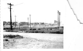
Looking south-west from Raymur Avenue
Part of City of Vancouver fonds

Looking south-west from Raymur Avenue
Part of City of Vancouver fonds

Area A-1, Relocation of Raymur Avenue
Part of City of Vancouver fonds
![Area A-2 [Looking north-west. from 1000 Block Union Street]](/uploads/r/null/1/8/c/18c52e9c6ad49618ad4970e1d4e3577ab59b064154b43a899ad4a2e76673fbc7/741daa67-a4fa-4c43-9c8d-f215ae9de615-CVA181-32_142.jpg)
Area A-2 [Looking north-west. from 1000 Block Union Street]
Part of City of Vancouver fonds
Downtown Vancouver commercial property slides (from Birth of a City, right)
File contains 35 mm color slides showing commercial buildings and street scapes in Downtown Vancouver, B.C. Some slides also show automobiles, street signs, traffic signals and other city signage.
Selected from Birth of a City - right
CVA 810-183: [Granville Street, Cunningham Drugs and neon signs]
CVA 810-184: From Water St. [Streetscape looking toward Eaton's]
CVA 810-185: Merchant's Bank 1 W. Hastings, Pioneer Square
CVA 810-186: Detail Southwest Arch Queen's Hotel [342 Water St.]
CVA 810-187: Cordova Detail
CVA 810-188: [Detail 321 Water St.]
CVA 810-189: [Detail 100-block West Hastings St. - Central building]
CVA 810-190: [building in the 100-block West Hastings St.]
CVA 810-191: [28 Water St.]
CVA 810-192: [26 Water St.]
CVA 810-193: [View of Cordova Street looking toward Army and Navy at 36 W. Cordova St.]

Granville Street, Cunningham Drugs and neon signs

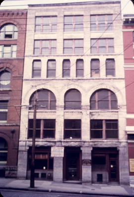
![[Pioneer Place, corner of Carrall Street and Hastings]](/uploads/r/null/f/1/f1fb96f366d0ef2e66033ee2509c84a10397ec618516e4e5310b9894be9473e6/3e478109-296b-4515-b3d2-92aa140f5d14-A10284_142.jpg)
[Pioneer Place, corner of Carrall Street and Hastings]
Part of Major Matthews collection

The official street name map of the City of Vancouver
Part of City of Vancouver fonds
Item is a map created to accompany a street naming by-law.
Vancouver (B.C.). Engineer's Office
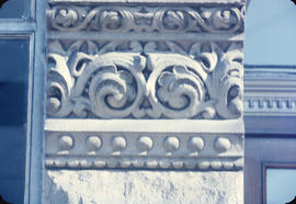
![Detail Southwest Arch Queen's Hotel [342 Water Street]](/uploads/r/null/4/1/417f8884a57dc37cc1fbca209b95aa604c8181c03ab4a87eafe8a9128f1bc417/7c9a4633-8910-49a9-ab29-b2413132b62f-CVA810-186_142.jpg)
Detail Southwest Arch Queen's Hotel [342 Water Street]

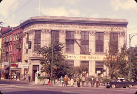
Merchant's Bank 1 West Hastings Street, Pioneer Square
Part of City of Vancouver fonds
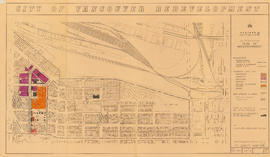
Item is a map showing boundaries of redevelopment and clearance areas, proposed land use, new streets and lanes, sites not to be acquired, and buildings to be retained in project 2. Map has been annotated with colour indicating land use and a proposed widening of Scotia Street. Base map shows building outlines and topographic contour lines, and covers the area bounded by Main Street, Clark Drive, Terminal Avenue, and Broadway

City of Vancouver redevelopment : project 2, area "H" and part of "B" : identification plan
Part of City of Vancouver fonds
Item is a map showing boundaries of clearance areas and ownership of property included in the acquisition program. Map has been annotated to show a possible amendment to the clearance area boundaries and a proposed widening of Scotia Street. Base map shows building outlines and topographic contour lines, and covers the area bounded by Main Street, Clark Drive, Terminal Avenue, and Broadway

The official street name map of the City of Vancouver
Part of City of Vancouver fonds
Item is a possibly earlier version of the Official street name map of the City of Vancouver ultimately adopted under By-law no. 4054. This version does not have the by-law information seen on the adopted version, and Edinburgh Street and a small area in southeast Vancouver are marked in red for an unknown reason.
Building in the 100-block West Hastings Street

Detail 100-block West Hastings Street - Central building
![From Water St. [Streetscape looking toward Eaton's]](/uploads/r/null/a/8/a8c61011a86310033f459397235f84cd09ca220d1f4e39440692804c777111ed/e318d142-7fd4-49f9-8d43-8556ca6d4ace-CVA810-184_142.jpg)
From Water St. [Streetscape looking toward Eaton's]


View of Army and Navy at 36 West Cordova Street and Woodward's "W" sign
![[Firefighters battling blaze at Passlin Hotel, 700 block Richards Street]](/uploads/r/null/5/6/4/5641b5fabc7f3acc6ed04ff5a4536e05e046766e1f840678824809879ab02ac7/4cadeaf9-8ebe-4b5b-97b1-6e7b9af8a59f-CVA354-262_142.jpg)
[Firefighters battling blaze at Passlin Hotel, 700 block Richards Street]
Part of City of Vancouver fonds

Part of City of Vancouver fonds
Item is a group of three photographs arranged vertically and affixed with tape. Annotation on top photo: "Rear of buildings in 400 block, Keefer Street." Annotation on middle photo: "East side of Burleith House." Annotation on bottom photo: "McLean Park High Rise in Background of Burleith House."

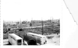
Looking south and south-west from Hastings Viaduct
Part of City of Vancouver fonds
Item is a panoramic photograph showing the views looking south and south-west from Hastings Viaduct. Annotations on back identifying X's and arrows. The X on the left shows "956 keener, one of two remaining properties to be demolished." The X on the right shows "930 E Pender, one of two remaining buildings to be demolished." The arrows show: "Russian Church and Russian Hall to remain."

Part of City of Vancouver fonds
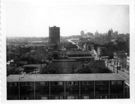
Old B.C. Electric Gas Plant from roof of McLean Park High-rise, looking east
Part of City of Vancouver fonds

New McLean park in foreground, 700 block Keefer in background
Part of City of Vancouver fonds

McLean Park with 700 Block Keefer in background
Part of City of Vancouver fonds

Part of City of Vancouver Archives technical and cartographic drawing collection
Part contains a street map of Greater Vancouver with street index, an inset map showing the streets of Horseshoe Bay, Whytecliff, and Caulfeild, and advertising Chevron gasolines and RPM motor oils.
Maps of Victoria and Vancouver Island, mileage chart and traffic routes
Part of City of Vancouver Archives technical and cartographic drawing collection
Part contains a street map of Victoria with street index, a map of Victoria and vicinity showing major roads, a map of Vancouver Island showing highways, a mileage chart, and traffic rules for Vancouver and Victoria.
Looking north across new McLean Park at 700 block Keefer
Part of City of Vancouver fonds
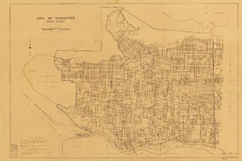
City of Vancouver, British Columbia

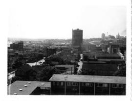
Intersection of Georgia and Dunlevy, looking north-west from roof of high-rise
Part of City of Vancouver fonds
View of Strathcona, McLean Park housing development in foreground
Part of City of Vancouver fonds
New McLean park in foreground, 700 block Keefer in background
Part of City of Vancouver fonds
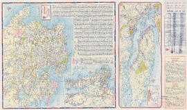
Vancouver and Victoria street and vicinity maps
Part of City of Vancouver Archives technical and cartographic drawing collection
Item is a street map designed to be folded into a pamphlet. Item contains maps of Victoria, Greater Vancouver, and Vancouver Island, a mileage chart, traffic rules, and advertisements.
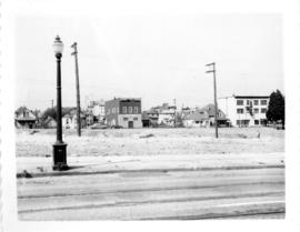
![[View of 41st Avenue at Blenheim Street]](/uploads/r/null/3/2/d/32d64e2ff48ba11eff30bc7c74f38494851ac99c919ae806c80dcc02ae7ac4e8/acd2b849-e883-44bf-aa18-b03cedbd0350-CVA480-336_142.jpg)
[View of 41st Avenue at Blenheim Street]
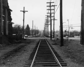
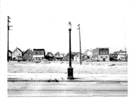
16th Avenue at Arbutus Street - Tracks looking south from north of 16th Avenue

700 Block East Georgia, looking west
Part of City of Vancouver fonds