
Exhibition Park, outdoor theatre
- AM1376-: CVA 72-24
- Item
- [between 1950 and 1952]
Item is a photograph of Scottish dancers on stage of the outdoor theatre at the Pacific National Exhibition.
Exhibition Park, outdoor theatre
Item is a photograph of Scottish dancers on stage of the outdoor theatre at the Pacific National Exhibition.

Item is a photograph of the Chief Skedans Mortuary Pole (replaced with a replica in 1965) near Lumberman's Arch in Stanley Park.


Stanley Park, fountain in duck pond
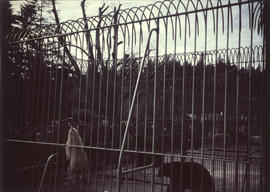
Stanley Park, bear cage with two polar bears and two grizzly bears
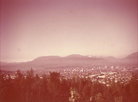
Vancouver from Little Mountain, Queen Elizabeth Park
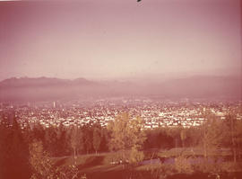
Vancouver from Queen Elizabeth Park
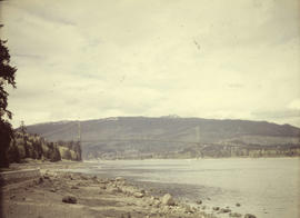
Stanley Park, Lions Gate Bridge from seawall beach

Item is a photograph of five totem poles near Lumberman's Arch in Stanley park. Two identified poles are the Thunderbird House Post pole at the far left, and the Chief Wakas totem pole second from the left.

Sheet C : University Endowment Lands to Discovery Street and Fourth Avenue to Sixteenth Avenue
Part of City of Vancouver Archives technical and cartographic drawing collection
Item is a section showing the area from the University Endowment Lands to Discovery Street and Fourth Avenue to Sixteenth Avenue. Includes streets and roads; blocks, lots and legal descriptions; and parks and schools. Annotations in ink.
Vancouver (B.C.). Office of the City Engineer

Sheet S.V. 12 : Fleming Street to Raleigh Street and Forty-eighth Avenue to Newport Avenue
Part of City of Vancouver Archives technical and cartographic drawing collection
Item is a section showing the area from Fleming Street to Raleigh Street and Forty-eighth Avenue to Newport Avenue. Includes streets, roads, blocks, lots, legal descriptions, parks, golf courses and schools. Annotations in pencil.
Vancouver (B.C.). Office of the City Engineer

Sheet B : Discovery Street to Trutch Street and waterfront to Fourth Avenue
Part of City of Vancouver Archives technical and cartographic drawing collection
Item is a section showing the area from Discovery Street to Trutch Street and waterfront to Fourth Avenue. Includes streets, roads and sewers; blocks, lots and legal descriptions; and parks and schools. Map shows Jericho Air Station and crown leases.
Vancouver (B.C.). Office of the City Engineer

Sheet S.V. 16 : Dawson Street to Boundary Road and Fiftieth Avenue to Sixty-third Avenue
Part of City of Vancouver Archives technical and cartographic drawing collection
Item is a section showing the area from Dawson Street to Boundary Road and Fiftieth Avenue to Sixty-third Avenue. Includes streets, roads, blocks, lots, legal descriptions, parks and golf courses.
Vancouver (B.C.). Office of the City Engineer

Sheet S.V. 17 : Jellicoe Street to Boundary Road and Sixty-third Avenue to Fraser River
Part of City of Vancouver Archives technical and cartographic drawing collection
Item is a section showing the area from Jellicoe Street to Boundary Road and Sixty-third Avenue to the Fraser River. Includes streets, roads, railway lines, blocks, lots, legal descriptions, parks and golf courses.
Vancouver (B.C.). Office of the City Engineer

Sheet S.V. 1 : Cambie Street to Carolina Street and Sixteenth Avenue to Twenty-eighth Avenue
Part of City of Vancouver Archives technical and cartographic drawing collection
Item is a section showing the area from Cambie Street to Carolina Street and Sixteenth Avenue to Twenty-eighth Avenue. Includes streets, roads, blocks, lots, legal descriptions, parks, nurseries and schools.
Vancouver (B.C.). Office of the City Engineer

Part of City of Vancouver Archives technical and cartographic drawing collection
Item is a section showing the area from Dumfries Street to Fairmont Street and Twenty-seventh Avenue to Thirty-seventh Avenue. Includes streets, roads, blocks, lots, legal descriptions, railway lines, parks and schools. Annotations in green pencil.
Vancouver (B.C.). Office of the City Engineer

Sheet S.V. 6 : Prince Edward Street to Bruce Street and King Edward to Thirty-fifth Avenue
Part of City of Vancouver Archives technical and cartographic drawing collection
Item is a section showing the area from Prince Edward Street to Bruce Street and King Edward to Thirty-fifth Avenue. Includes streets, roads, blocks, lots, legal descriptions, parks, cemeteries, and schools. Annotations in ink and pencil.
Vancouver (B.C.). Office of the City Engineer

Sheet S.V. 14 : Duchess Street to Boundary Road and Twenty-ninth Avenue to Fortieth Avenue
Part of City of Vancouver Archives technical and cartographic drawing collection
Item is a section showing the area from Duchess Street to Boundary Road and Twenty-ninth Avenue to Fortieth Avenue. Includes streets, roads, blocks, lots, legal descriptions, parks, schools and B.C. Electric Railway lines. Annotations in pencil.
Vancouver (B.C.). Office of the City Engineer

Coronation Garden, 1953, Stanley Park, Vancouver, Canada

Sheet S.V. 3 : Cambie Street to Prince Edward Street and Thirty-ninth Avenue to Fiftieth Avenue
Part of City of Vancouver Archives technical and cartographic drawing collection
Item is a section showing the area from Cambie Street to Prince Edward Street and Thirty-ninth Avenue to Fiftieth Avenue. Map shows streets, roads, blocks, lots and legal descriptions, and the locations of parks, schools, golf courses and Mountainview Cemetery.
Vancouver (B.C.). Office of the City Engineer

Sheet S.V. 2 : Cambie Street to St. George Street and Twenty-eighth Avenue to Thirty-eighth Avenue
Part of City of Vancouver Archives technical and cartographic drawing collection
Item is a section showing the area from Cambie Street to St. George Street and Twenty-eighth Avenue to Thirty-eighth Avenue. Map shows streets, roads, blocks, lots and legal descriptions and the locations of parks, schools, reservoirs and Mountainview Cemetery. Annotations in pencil.
Vancouver (B.C.). Office of the City Engineer

Sheet S.V. 9 : St. George Street to Argyle Street and Fifty-eighth Avenue to Fraser River
Part of City of Vancouver Archives technical and cartographic drawing collection
Item is a section showing the area from St. George Street to Argyle Street and Fifty-eighth Avenue to Fraser River. Includes streets, roads, blocks, lots, legal descriptions, railway lines, parks and schools.
Vancouver (B.C.). Office of the City Engineer

Sheet S.V. 5 : Ash Street to St. George Street and Sixty-third Avenue to Fraser River
Part of City of Vancouver Archives technical and cartographic drawing collection
Item is a section showing the area from Ash Street to St. George Street and Sixty-third Avenue to Fraser River. Includes streets, roads, blocks, lots, legal descriptions, parks and railway lines.
Vancouver (B.C.). Office of the City Engineer

Sheet S.V. 7 : Prince Edward Street to Argyle Street and Thirty-fifth Avenue to Forty-seventh Avenue
Part of City of Vancouver Archives technical and cartographic drawing collection
Item is a section showing the area from Prince Edward Street to Argyle Street and Thirty-fifth Avenue to Forty-seventh Avenue. Includes streets, roads, blocks, lots, legal descriptions, parks, cemeteries, and schools.
Vancouver (B.C.). Office of the City Engineer

Sheet S.V. 15 : Dawson Street to Boundary Road and Foster Avenue to Fiftieth Avenue
Part of City of Vancouver Archives technical and cartographic drawing collection
Item is a section showing the area from Dawson Street to Boundary Road and Foster Avenue to Fiftieth Avenue. Includes streets, roads, blocks, lots, legal descriptions, parks and schools. Annotations in pencil.
Vancouver (B.C.). Office of the City Engineer

Sheet S.V. 11 : Fleming Street to Killarney Street and Thirty-seventh Avenue to Forty-eighth Avenue
Part of City of Vancouver Archives technical and cartographic drawing collection
Item is a section showing the area from Fleming Street to Killarney Street and Thirty-seventh Avenue to Forty-eighth Avenue. Includes streets, roads, blocks, lots, legal descriptions, parks and schools. Annotations in green pencil. Annotations in ink and pencil.
Vancouver (B.C.). Office of the City Engineer

Sheet S.V. 4 : Ash Street to St. George Street and Fifty-first Avenue to Sixty-third Avenue
Part of City of Vancouver Archives technical and cartographic drawing collection
Item is a section showing the area from Ash Street to St. George Street and Fifty-first Avenue to Sixty-third Avenue. Includes streets, roads, blocks, lots, legal descriptions, parks, golf courses, hospitals and schools.
Vancouver (B.C.). Office of the City Engineer

Sheet S.V. 8 : Prince Edward Street to Argyle Street and Forty-seventh to Fifty-eighth Avenue
Part of City of Vancouver Archives technical and cartographic drawing collection
Item is a section showing the area from Prince Edward Street to Argyle Street and Forty-seventh to Fifty-eighth Avenue. Includes streets, roads, blocks, lots, legal descriptions, parks and schools.
Vancouver (B.C.). Office of the City Engineer

Plaque being fastened to Centuries Rock, Queen Elizabeth Park
Part of Artona Studios fonds
![Q[ueen] E[lizabeth] Park](/uploads/r/null/a/a/7/aa7b5de4a496a4361547fbc2bf4873af97ae50546ca945b69fede87963c9f1ee/ab594034-1dcc-4421-aa32-528f015e5011-CVA1187-104_142.jpg)
Part of Artona Studios fonds

Queen Elizabeth Park at end of construction
Part of Artona Studios fonds
![Q[ueen] E[lizabeth] Park](/uploads/r/null/b/1/7/b172b98142016001597649e68760ee921ad4c672318d826c2ed33b3c24ed6681/85cb4881-634a-455a-83c8-6b61f6d571ac-CVA1187-114_142.jpg)
Part of Artona Studios fonds
![Q[ueen] E[lizabeth] Park](/uploads/r/null/0/0/b/00be6d546fd18623b889d50c756e7d06386e326a820ba7b9d11dfb145bf5b48f/69048827-ffd7-4c99-98a2-048dbbc3ecaa-CVA1187-105_142.jpg)
Part of Artona Studios fonds
![Q[ueen] E[lizabeth] Park](/uploads/r/null/a/c/d/acd8854613c2cfad01eeee88b56c2d2f431e2200f2ccf351ddeb91c21a5dbe39/5d66542a-50d1-4d95-980c-6448fd2b1fd5-CVA1187-112_142.jpg)
Part of Artona Studios fonds

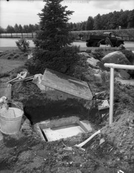
Putting time capsule into hole to be covered with Centuries Rock, Queen Elizabeth Park
Part of Artona Studios fonds
![Q[ueen] E[lizabeth] Park](/uploads/r/null/3/f/7/3f7aa4f024e59853e278a3df67c920ec2dbdd874d4e177adaba509222c701825/6d62c3b0-7b2c-48ba-a335-c91895fc33a6-CVA1187-94_142.jpg)
Part of Artona Studios fonds
![Q[ueen] E[lizabeth] Park](/uploads/r/null/6/8/3/683bd4cf273c217836a62fd10636b3dc890779569313f2d8cc81b44d8ff0bf39/b9e5be8a-53ce-4fe9-bd21-8816f444267b-CVA1187-102_142.jpg)
Part of Artona Studios fonds
![Q[ueen] E[lizabeth] Park](/uploads/r/null/0/3/4/0341c7188c1fee2cd8d81b21d2b0d8a199e7cb50c08a843346e2d63961a6bf5d/b1b63bfe-0cb0-4a74-b4b7-05fd03631a37-CVA1187-103_142.jpg)
Part of Artona Studios fonds
Part of Artona Studios fonds
![Q[ueen] E[lizabeth] Park](/uploads/r/null/4/8/4/484dd62a03a61c8beed91015360c801177c1f5f33080da3bbceb3b3565fbc3be/218680c1-9c10-4552-9988-8eae7235ae50-CVA1187-123_142.jpg)
Part of Artona Studios fonds
![Q[ueen] E[lizabeth] Park](/uploads/r/null/d/2/4/d24607670387bf5976b0b933e33df9822fc6db6fade75837c01b08a09cc56a7a/422c3e71-9c9a-4bb5-8675-a6c6661b5475-CVA1187-124_142.jpg)
Part of Artona Studios fonds

Ceremony in Queen Elizabeth Park
Part of Artona Studios fonds
Item is a photograph showing man at microphone, flag draped onto rock.

Man holding flag over rock, boy scouts standing behind him, Queen Elizabeth Park
Part of Artona Studios fonds

Ceremony in Queen Elizabeth Park
Part of Artona Studios fonds
Item is a photograph showing a man at a microphone, a flag draped on a rock, with crowd looking on.

Part of Artona Studios fonds

Moving Centuries Rock onto site containing time capsule, Queen Elizabeth Park
Part of Artona Studios fonds
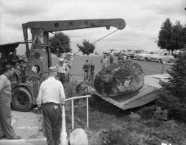
Centuries Rock being moved into place on top of time capsule, Queen Elizabeth Park
Part of Artona Studios fonds
![Q[ueen] E[lizabeth] Park](/uploads/r/null/3/1/0/3103bb769143b49453a87d85f267c970095f6daa160391d3d8ea00cfcee7cde0/09b90c03-fd8b-458b-84a2-22ca0f9e4ef7-CVA1187-97_142.jpg)
Part of Artona Studios fonds
![Q[ueen] E[lizabeth] Park](/uploads/r/null/e/e/b/eeb147085940a43cdcc66b0d50b13e19fc9529b419dae6a008bdc1a23d9f9479/71ae0db5-9793-491f-8d19-e6daa8e0bb22-CVA1187-98_142.jpg)
Part of Artona Studios fonds
![Q[ueen] E[lizabeth] Park](/uploads/r/null/f/4/f/f4fb550647fd647b2bd6cae229aa9d8b16ff2b0041a2172531b37c73b5e0c254/076121fe-5258-4c72-aa07-6a55ae1e0999-CVA1187-106_142.jpg)
Part of Artona Studios fonds