![Vancouver, B.C. Plan showing location of water pipes, hydrants, etc. [Fairview slopes]](/uploads/r/null/6/9/69e0d6904facfa2a814069c15122fba46fc4d8077bff76402e95484a4b13d4d8/313b8940-1e98-45d4-b077-abe0f6bee66a-MAP72_142.jpg)
Vancouver, B.C. Plan showing location of water pipes, hydrants, etc. [Fairview slopes]

Vancouver, B.C. Plan showing location of water pipes, hydrants, etc. [Westminster Avenue to McLean Drive]
![Hastings Townsite [Boundary Road to 5th Avenue to Kamloops Street (?) to 33rd Avenue]](/uploads/r/null/7/f/0/7f0fe2a27b9af4f20ad7837792af3bbb3aa93c3487024e69b14fa38144134f19/8e7a0e66-c6cc-40ca-bbac-4ea73db77437-LEG1800_142.jpg)
Hastings Townsite [Boundary Road to 5th Avenue to Kamloops Street (?) to 33rd Avenue]
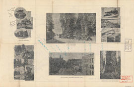
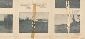
Views of Vancouver

Map and views of the terminal city, Vancouver, British Columbia, Canada : map cover
![Vancouver, B.C. Plan showing location of water pipes, hydrants, etc. [West End]](/uploads/r/null/0/5/05354f71931ba85b05864a2adeb3580a6365ddf962e5084f0bb51c68608364a0/3f57f512-bd27-404e-a332-e0881405c2ac-MAP72_142.jpg)
Vancouver, B.C. Plan showing location of water pipes, hydrants, etc. [West End]

Map of Grandview and east end

Warehouse and store sites : very centrally located
![Hastings Townsite [Boundary Road to English Bay to Commercial Drive to Charles Street]](/uploads/r/null/f/f/f/fff4026408c5cdfe071e2699b8a35b248daec6b4d059622bf14a49b96a15fb3c/a21002e4-eead-4468-b03a-a44b355308fa-LEG1800_142.jpg)
Hastings Townsite [Boundary Road to English Bay to Commercial Drive to Charles Street]

Vancouver, B.C. Plan showing location of water pipes, hydrants, etc. [Victoria Drive to First Avenue to Prince Edward Street to 16th Avenue]
![Vancouver, B.C. Plan showing location of water pipes, hydrants, etc. [Burrard Street to Gore Avenue]](/uploads/r/null/7/7/7797d041e72dece35da90eab6733a9db50a0b2115ad816578d3633a58bf31761/ebc0f54a-c23a-425c-816d-1dd268a2e4e7-MAP72_142.jpg)
Vancouver, B.C. Plan showing location of water pipes, hydrants, etc. [Burrard Street to Gore Avenue]

Map and views of the terminal city, Vancouver, British Columbia, Canada : inside map cover
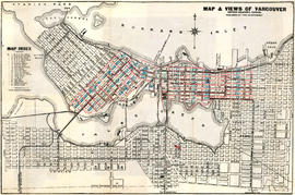
Map and views of Vancouver, British Columbia, Canada
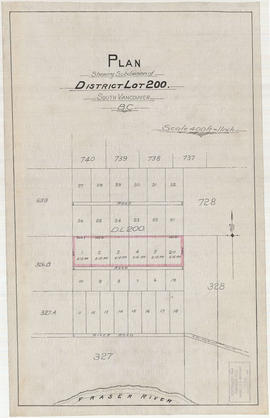
Plan shewing subdivision of District Lot 200. South Vancouver, B.C.

British Columbia railway belt

Price list of new subdivision : Hastings Townsite, close to city limits
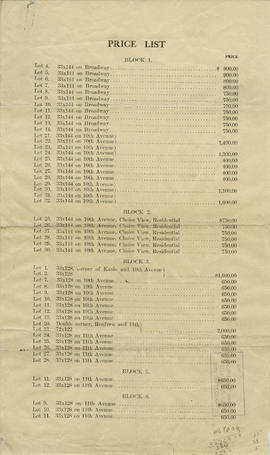
Price list
![Vancouver, B.C. Plan showing location of water pipes, hydrants, etc. [Kitsilano]](/uploads/r/null/0/e/0e33cc4d2f081f551fe6919d35ea37236a6e237a2f5927834d275556995fccfc/0f6ac1ff-8457-41f3-a386-26328c66a4b0-MAP72_142.jpg)
Vancouver, B.C. Plan showing location of water pipes, hydrants, etc. [Kitsilano]

Plan of the City of Vancouver, British Columbia
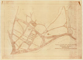
Plan of grounds near bridge entrance, Stanley Park, Vancouver, B.C. : showing proposed improvements coloured red
![Vancouver, B.C. Plan showing location of water pipes, hydrants, etc. [South Granville]](/uploads/r/null/e/a/eadb6d7351a77ac5788832abd83754cbe2966049728712aa7773bf6f2a74ff34/819e5ce5-621b-43ff-b1f5-f3bf4cac0562-MAP72_142.jpg)
Vancouver, B.C. Plan showing location of water pipes, hydrants, etc. [South Granville]

Coal Harbour, Vancouver, B.C.
![Vancouver, B.C. Plan showing location of water pipes, hydrants, etc. [Hastings Sunrise]](/uploads/r/null/b/c/bc8cb6a6f5ac5df0dd88a65e8a29ecceca242bde2c1b605533ad17eb835cc450/b2741291-73c5-4a98-9f41-db7fdc46fe83-MAP72_142.jpg)
Vancouver, B.C. Plan showing location of water pipes, hydrants, etc. [Hastings Sunrise]
![Vancouver, B.C. Plan showing location of water pipes, hydrants, etc. [Grandview]](/uploads/r/null/8/8/88632d271347b57b818fde723ce9ea599c725a5190b4fb2bbb11e5f98e3809ae/3657fbb2-2cf9-4d03-b885-3836ab221252-MAP72_142.jpg)
Vancouver, B.C. Plan showing location of water pipes, hydrants, etc. [Grandview]

Plan of townsite at Eburne

Map and guide of Greater Vancouver

Plan of the municipality of South Vancouver
![Plate 46 [Thurlow Street to Canadian Pacific right-of-way to Bute Street to Georgia Street]](/uploads/r/null/5/9/f/59fddbd648aac61a1c6c56b0121fac2a9f07bd91756ebdf08cd47779553b2c7d/c80bf37d-14f8-4766-8e8c-2542a5ce2b71-1972-582_142.jpg)
Plate 46 [Thurlow Street to Canadian Pacific right-of-way to Bute Street to Georgia Street]

Plan of proposed dam, locks and wharves. Second Narrows, Burrard Inlet

Map of the Lower Mainland showing municipal boundaries and lot numbers
![Plan of re-subdivision of lots 3 to 14, subn [subdivision] 2 of bk [block] 3. D.L. 391 & 392](/uploads/r/null/4/a/4a0ea6aa076433c7bcad0c847f7acb3bb1046f7abf2801c48b97d9ca58f49a73/9bd508e4-c85e-4090-b266-27571c5d4dbc-MAP754_142.jpg)
Plan of re-subdivision of lots 3 to 14, subn [subdivision] 2 of bk [block] 3. D.L. 391 & 392

Map of the harbour of New Westminster, British Columbia

A sketch design for a nonconformist church

Lot numbers, boundaries, railway lines and street names in the municipality of Point Grey

The Municipality of South Vancouver
![Map of Stanley Park [site plan]](/uploads/r/null/1/c/1c9f6dc06e0884db9e77fbf60ada5f034a83d9de980993fddeb5e2475c9e2b97/52d1c868-f7bb-48bd-a2e8-0fa3444cfeec-MAP62_142.jpg)
Map of Stanley Park [site plan]
Map of South Vancouver

Map of Vancouver, B.C. including Hastings Townsite and D.L. 301

Map of West Vancouver and vicinity

Map cover

Map of the Fraser Valley showing railway lines and district lots

Plan of Greater Vancouver, British Columbia

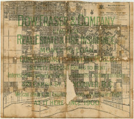
Map of the city of Vancouver, British Columbia
Map of West Vancouver and vicinity : verso

Enjoyable trips on our interurban lines

Map of Greater Vancouver

What the man who comes to Vancouver wants to know
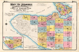
Plate 1: Key to Plates. Goad's Atlas. City of Vancouver and Surrounding Municipalities. Volume One
![Plate 8: West End [Cardero Street - Barclay Street - Park Road - Beach Avenue - Davie Street]](/uploads/r/null/6/d/6/6d680461017be540974f2eb8ba9641e6ea703be5860e413e63fdfe34f65ceead/e073c970-9088-45fe-8202-64066fbe2941-MAP342a_142.jpg)
Plate 8: West End [Cardero Street - Barclay Street - Park Road - Beach Avenue - Davie Street]
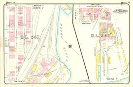
Plate 14: West End - southeast corner and BC Electric Railway yards