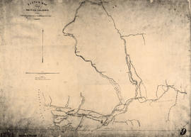
Sketch map of part of British Columbia showing trails and routes of communication
- AM54-S13-: MAP 1047.01
- Item
- [1862?] (copied 194-?)
Part of Major Matthews collection
Item is a photostatic copy of a manuscript map showing trails and routes of communication in a portion of British Columbia from the Canada-U.S. border in the south to Seaton Lake in the north, and from the coast to Vermillion in the east. The section of coastline extends from Semiahmoo Bay in the south to Point Atkinson in the north. Map shows the location of mule trails and wagon roads, and includes a trail in progress from New Westminster to Burrard Inlet (North Road), trails from Whatcom to Hope and Semiahmoo to Derby, the Hudsons Bay Brigade Trail, Douglas Road, a trail proposed by Colonel Moody from New Westminster to Fort Hope, and the Dewdney Trail. Included with the map is a 1949 letter from Major Matthews, City Archivist, to J.M. Pearce in which Matthews describes the map, and a 1952 enquiry from L.B. [Housler] for a map showing the Dewdney Trail.

![[Full length studio portrait of] John Woolsey](/uploads/r/null/a/f/af5720e477d9072c3383876a2c8b977e2f9335444842deecbb4de8240deea9a8/1fa39eda-b6aa-479e-97af-172a0b94e8aa-A02517_142.jpg)
![Country lands, New Westminster District [D.L. 185]](/uploads/r/null/2/f/f/2ff00fcb19a3dd23ff02f3355264a2fef808da9c2362a01bc084c87c334bbb27/0143c5f1-96bf-4733-b1d3-2386ba496659-LEG1801_142.jpg)


![D.L. 184 westward to [D.L. 181?]](/uploads/r/null/d/6/6/d66e699892f5f3573732fab74345928c93375400f48a564db38b4128d7809aa6/10ea8d79-243c-45ea-99f9-60f17d329c2c-LEG1801_142.jpg)


![[View of the Thompson River east of Lytton]](/uploads/r/null/b/5/b57bdc9554f4c089b187d1c5f5b233acbf931272e64dad2a0b54dd28040149cf/21978601-2e31-4d42-983f-3d601c619e55-A33843_142.jpg)
![[View of Yale from across the river]](/uploads/r/null/d/8/d88bb63c674fa01155005f050b7f8d2ee6d5c424265116251dcf4dda08e4b73c/32c5ed3b-5b71-4c9d-8738-671a1fb58eef-A33844_142.jpg)

![[A part of the Cariboo Road between Hell's Gate and Chapmans]](/uploads/r/null/0/9/09f564a5e10bf8b5b528d6cef608078781396fb613caaf73894b7adb3890e28a/20f81bdb-6c16-431f-a020-ec7dbd161749-A33841_142.jpg)
![[A part of the Cariboo Road]](/uploads/r/null/3/2/325b5ab94be7474ca99a4c6172efdaacbc096e5e7d14797a940ba9f1978735da/e943c3c1-170d-4b5c-a086-104eb24bb724-A33836_142.jpg)
![[View of Spences Bridge]](/uploads/r/null/f/d/fde21c3df95bc8ea353a096dfa36a64257e960c089734510aecbf780ba673c38/905a7d1e-4b81-48f2-a730-cf093778e339-A33845_142.jpg)
![The Cameron C[ompanies?] claim "Camerouton" Williams Creek, B.C.](/uploads/r/null/5/8/586bbd218cda2979c8a18a35132229376962b6000903d6a90345763e5f4917c4/cc30a9b4-062f-43eb-b1e8-aaebd3631afd-A26627_142.jpg)
![[A part of the Cariboo Road]](/uploads/r/null/0/4/0451742b8f917ab9edd6b6e459fc385a9414ee9989dcb46d1e7183d293552284/cd8f24b9-f274-4655-bd36-999be6a1c680-A33839_142.jpg)
![[Nicaragua Bluff on the Cariboo Road]](/uploads/r/null/2/1/212ee267c1018cf936840d29525145920f13592d01c4166f02011afb7960667e/dfe8ff21-00f5-46e8-af64-5e05462e6164-A33842_142.jpg)
![[Hill 19 on the Cariboo Road]](/uploads/r/null/a/7/a7b7a913e1e5325c312ae63d254ada4c643f0714061a8c4eae87d2593375f76d/c51b19f1-c3f8-4602-ab31-e440fec83226-A33838_142.jpg)
![[The Cariboo Road between Hell's Gate and Alexandra Bridge]](/uploads/r/null/c/a/ca92cca8713ae10c685a422d7a45a7ee840c766362394ef7ed5e775c28cc9de9/3335f8a1-c7b7-46ce-af78-7823f86b7b38-A33840_142.jpg)
![[Cariboo road wooden bridge]](/uploads/r/null/6/8/68ce5215eae39e398be57511d2452aa8f265152be77a8b6ed651889e33f9a344/a7cf865a-d31b-4eda-b323-60e372cd7756-A24445_142.jpg)
![[Victoria Volunteer Rifle Corps also known as "The African Rifles"]](/uploads/r/null/a/4/a46cfceaaf41efface9c36e8f348883d663e0fa7bbf0e52ef6e131db02c318de/80e181fd-e646-4d08-951b-944ce4c1d55d-A32148_142.jpg)


![J.C. Eastcott [Specialist] Surgeon H.M.S. Reindeer](/uploads/r/null/e/a/eaaaa321cb5576f71c45d4be94801aeb55c92fbca3b9baf1bea49458401b6227/c6cdb715-0808-4dc3-a545-0741a6769851-A35884_142.jpg)
![[The delegates who made up the scheme of the Confederation of Canada]](/uploads/r/null/c/8/c823d01c4a3e2efdd1672d31f79fac471a23fadefc1095bc5716c026d97bebe8/26e92535-dcff-4f54-8686-894cc7c805fd-A34830_142.jpg)
![[Studio portrait of a baby in a high chair]](/uploads/r/null/4/6/461bf3f892fd6eab92d61421c82de7eb5e6b9a37912b58ed1ac79847f99bec2c/73af12c8-0abe-470d-a343-e2947d28d675-A01841_142.jpg)


![[Mr. and Mrs. John Linn]](/uploads/r/null/f/1/f15ad8f20d26462863e1210e99859525f317649976c206b03ee09ddfaf34e067/e4883cff-d744-4d1a-ad4b-551fe1f88127-A61472_142.jpg)
![[Edgar Dewdney]](/uploads/r/null/5/0/50fb12601b9e5492031f6fe5cdbd06857ed39b637dd846f84ca3df6c24e5c8c0/5e9f2509-8132-4c14-bf72-fb269e4e7daf-A35911_142.jpg)
![[Barnard's Express and Stage Line with Royal Mail enroute to Barkerville ]](/uploads/r/null/8/f/8f1cd724a7ea0cb0754fe91d3bd553d4b5dbb3ea1b41d2cd9a46ae333ab72ea9/81e20b25-119d-4c84-8ffd-3bca5d2d1723-A37625_142.jpg)
![[Osborne J. Pierce in Civil War uniform]](/uploads/r/null/f/0/f00a5b977bf977621b2e167c960493cc18e428dee543a01d233cac080dc7b536/2582ebb1-9f54-46ae-8ba6-af5542fcd07c-CVA1477-437_142.jpg)
![[Sir Sandford Fleming]](/uploads/r/null/1/2/12dc7712a9a6229d5caf7c7b1afbe2dcf7acff10a6328b94503b7252194cc61b/004cab06-a03f-4af4-b783-f7f2721e4ac2-A36012_142.jpg)
![[Jean Baptiste Lolo St. Paul and family in front of a Hudson's Bay Company cabin, Kamloops, B.C.]](/uploads/r/null/f/4/f48aca9139c4a72c80c158cc7adaa191bb64e948a5688d0d8c56fce8cc2b9cb4/b0b78bc7-a3e4-4942-aab1-000b5f996d8b-A26501_142.jpg)
![[Frederick William Sentell]](/uploads/r/null/d/f/df101d314cabfbaaa4a828e4ee557fcb2cdb0de84446509bb4644d17493629d4/4c69c9f2-6d1f-4281-8c6e-b3ecaf420e11-A62075_142.jpg)


![[Reverend William Burton Crickmer]](/uploads/r/null/7/5/7572131db658c45321614ab511c9a772e8bc13ae4fa29b0f01316f61301b4761/38bf8f16-f2e5-4a31-b30c-3cf4e11d001f-A35888_142.jpg)
![[Parliament Buildings under construction]](/uploads/r/null/9/1/91b96dd222923539b42dc7bbb94839c508c9c793785af057b041febb36787765/4ad84ebc-7659-40d1-9c9d-63b976eebacd-A33125_142.jpg)
![[Hudson Bay Company's S.S. "Beaver"]](/uploads/r/null/e/8/e8a53b2741fa5f8533d9eba315b0638435205092f440bb0f46821f9d9efc9afc/105dcd63-9309-4438-bcb9-cfcb8ea3c65a-A23968_142.jpg)

![[Parliament Buildings under construction]](/uploads/r/null/3/f/3f545f768ac89e735bd788ed3f9d7a5b73fc94977bd5d4d348c6dd74b228a4c1/5d5db37d-42a3-4ea6-8b9f-d565edbd346d-A33126_142.jpg)
