![On the slopes of Dam...Peak [showing Mount Crown and Goat Mt.]](/uploads/r/null/a/5/a532a90312925b6cd4735299c66eddc2030c2ad66b21ad58ba4c2a007c829482/7b1ab825-0925-49d9-ad28-63d39dde985d-A19194_142.jpg)
On the slopes of Dam...Peak [showing Mount Crown and Goat Mt.]
- AM54-S4-1-S-1-: S-1-12
- Item
- [1902]
Part of Major Matthews collection
1645 results with digital objects Show results with digital objects
On the slopes of Dam...Peak [showing Mount Crown and Goat Mt.]
Part of Major Matthews collection
![The Camel [on Mount Crown]](/uploads/r/null/b/c/bc2ebb89efa458300768fa1724040b774c79d13e09ab1cb55b72f0871a0a0b5e/9500233e-78d2-452b-a249-1da7faf5cdf6-A19209_142.jpg)
Part of Major Matthews collection
![Tinnis on the Peak [of Mount Crown holding the Union Jack]](/uploads/r/null/3/2/326fca61d8b7d724af431c6da19c0ad96f00624c93019adca66232f2b9aa242f/aa10b80f-8909-4283-b019-6d458564d2f3-A19206_142.jpg)
Tinnis on the Peak [of Mount Crown holding the Union Jack]
Part of Major Matthews collection
Photograph shows Arthur Tinniswood Dalton seated at the summit of Mt. Crown. J.S. Matthews notes with print.
![[Capilano River]](/uploads/r/null/f/3/f30cb657adf7f068f2f6e59ac0df8a556b4f4555cc6533a9a25b5d45ebed9403/fac77edb-28ac-4eb0-9ba5-dd4517ef052c-A26838_142.jpg)
Part of Major Matthews collection
![Plan of town of Lonsdale : situate [sic] on harbour opposite City of Vancouver](/uploads/r/null/c/5/d/c5d4b56db1d7f9e1cf57dd5a974f6fcb23507e64543bad1bdd8f62139042389f/1cc57eaf-6c92-438e-a65d-335940738df7-MAP686_142.jpg)
Plan of town of Lonsdale : situate [sic] on harbour opposite City of Vancouver
Part of City of Vancouver Archives technical and cartographic drawing collection
Map shows lot numbers and boundaries in the area from Keith Road in the north to Burrard Inlet in the south and from St. Patrick's road in the east to Chesterfield Avenue in the west. Several lots at St. Andrews Road and Fourth Street are hand-coloured pink, but the significance of the colouring is unknown. The ancillary map is an index map showing the location of Lonsdale in relation to Burrard Inlet and Vancouver.
![[The John J. Woods family in Lonsdale Gardens]](/uploads/r/null/2/f/2f60bf3104eb6dc25b3c384f772002ea4f6cb69b6122a63c555eb086acc30e74/18ee6e8a-a315-4682-aa91-60b1e8d5d9ee-A33957_142.jpg)
[The John J. Woods family in Lonsdale Gardens]
Part of Major Matthews collection
Group portrait showing Mr. John J. Woods, Mrs. Woods (nee Anna Von Koenig) and children Nora, John Jr., Stanley, Mervin and Henry
![[An unidentified man in the woods near Seymour Creek]](/uploads/r/null/c/b/cb54afd1e8b41eed9dbc58c69cd704f18be200d7a03b00eab3960a0683aad79b/1a42f753-6182-4f6f-a3c1-d1fc288bc0aa-A62841_142.jpg)
[An unidentified man in the woods near Seymour Creek]
Part of Major Matthews collection
![[An unidentified man in the woods near Seymour Creek]](/uploads/r/null/e/7/e72a3a0e44fc55e0277299889973e62a3b2e8e1aa15a56804286778b77c5c2b2/f3974073-d32d-445a-ab85-faf7b47f5145-A62840_142.jpg)
[An unidentified man in the woods near Seymour Creek]
Part of Major Matthews collection
![[An unidentified man fishing in Seymour Creek]](/uploads/r/null/0/a/0a92b927e407e548623a40e617b9670bd05b2100d8c69eb2d006821c835bb431/bb732c98-f08d-479e-8ef6-4d1a2e9108c5-A62839_142.jpg)
[An unidentified man fishing in Seymour Creek]
Part of Major Matthews collection
![[John and Janet Barrow residence near Lynn Creek]](/uploads/r/null/e/7/e7b0ea06883db050258a04a55c24dfcfae015fcf0c77424a21f3c62856415b76/687faf2d-43a5-49a9-8715-c1b703fdafde-A07819_142.jpg)
[John and Janet Barrow residence near Lynn Creek]
Part of Major Matthews collection
J.S. Matthews' notes with print or negative in Archives.
![[Canal diggers at Capilano Dam]](/uploads/r/null/3/8/38cc2935e908205e48b5bff80d4903ac39e56221cb88d90c678afd09fef55a08/c68f46a6-6d28-4b4e-86b1-02034a5b9e38-A25749_142.jpg)
[Canal diggers at Capilano Dam]
Part of Major Matthews collection

Civic Official Visit - Capilano Dam
Part of Major Matthews collection
Photograph shows Alderman McQueen, Alderman Robert Grant, Alderman Bethune, W.H. Armstrong, Alderman W.H. Wood, Steve Maddison's uncle, Colonel Tracy, Sam Robb, Pete Larson, W.F. Findlay and others
![[Annual official visit of Council, officials and guests at Capilano Waterworks Dam]](/uploads/r/null/e/1/e1ab9cc1d898053daf24f54c91fa897052fc6a3ec607e21de0c69c21cc0a30ee/33d5d8b2-1d85-45c0-9219-dafa3e8bde37-A25801_142.jpg)
[Annual official visit of Council, officials and guests at Capilano Waterworks Dam]
Part of Major Matthews collection
Group portrait. Men identified: Back row: W.C. Ditmars, Thomas F. McGuigan, Mr. Blackmore, Mr. Brown, Ald. Shaw, William Quann, Ald. C.H. Wilson, J.M. Bowell, J.O. Benwell, Ald. McSpadden. Middle row: Mr. Rose, Major F.W. Boultbee, Peter Larsen, Mr. McCready, Ald. McQueen, H.J. Painter, George F. Baldwin, Ald. McDonald, J.E. Miller, Ald. Bethune, Ald. Peter Wylie, Robert Marrion. Front row: Mr. Walton, Rev. A.W. McLeod, T. H. Tracy, Ald. W.J. McGuigan, Ald. Foreman, Mr. Cowderoy
![[Group portrait of the Charles Gross family on the porch of residence - 83 Chesterfield Avenue]](/uploads/r/null/b/6/b68913a9fe0461f81c23a0032d86f076f64f89b1410eca54d7f1482818379bb0/42b94d81-f3f6-4bd4-b943-a1312fda30b8-A24877_142.jpg)
[Group portrait of the Charles Gross family on the porch of residence - 83 Chesterfield Avenue]
Part of Major Matthews collection
![St. Andrew's Presbyterian Church, Sixth Street and Keith Road [North Vancouver]](/uploads/r/null/0/e/0e761332a5103fa062e695d1eb664edc75822052d6af9f7ddeb46f6bd2d1a339/b54e9546-e501-4e46-81fb-f8a6e234b218-A02245_142.jpg)
St. Andrew's Presbyterian Church, Sixth Street and Keith Road [North Vancouver]
Photograph shows the exterior of church building, with logs, tree stumps, and other debris surrounding the site. Photograph also shows a boy on the front steps of the church.
![[John Barrow and John Reid sitting on a stump]](/uploads/r/null/3/8/38bd718a00dfb2e3e23b6033e6085598db7de97569dcee7687c2d82a68ec1f09/3cc1f614-3f70-4714-9dae-6c93d2a09d8a-A33973_142.jpg)
[John Barrow and John Reid sitting on a stump]
Part of Major Matthews collection
![St. George Hamersley's house [under construction]](/uploads/r/null/d/6/d6e31ecc467270b1d91156c6887516e659bb663cc683fbaf7e3a9a132ca72c91/b31aaf9b-aea7-44d7-b0b0-7c4ed01b1f27-A46631_142.jpg)
St. George Hamersley's house [under construction]
Part of Major Matthews collection
![[Young man travelling across Capilano River dam in a cable car]](/uploads/r/null/5/0/5004fe867b45ebe8b31779d7208183a43b8362ff03c833d99b05f2cc1377ad3b/6cdecfaa-8878-407b-980f-4ce1affd5185-A02420_142.jpg)
[Young man travelling across Capilano River dam in a cable car]
Photograph also shows houses and mountains in the background.
![[Group portrait of the Charles Gross family on the verandah of residence - 83 Chesterfield Avenue]](/uploads/r/null/b/c/bc33b9a92dc03f8cde84366b7fff5587df62b25a192274db27fbe8cc3195b1c4/e0d582b5-9e8f-4b01-8a2b-448935efeadf-A24878_142.jpg)
[Group portrait of the Charles Gross family on the verandah of residence - 83 Chesterfield Avenue]
Part of Major Matthews collection
![[John and Janet Barrow residence near Lynn Creek]](/uploads/r/null/5/e/5e49ce9a99d1ca15653d9e5cd818da2a16567a23f2e0f0f0c7c9c75b68135a1f/7c5e206f-8d27-4e83-91e5-a78309377029-A07820_142.jpg)
[John and Janet Barrow residence near Lynn Creek]
Part of Major Matthews collection
J.S. Matthews' notes with print or negative in Archives.

Butchers Picnic in North Vancouver
![[Exterior of the North Vancouver Hotel]](/uploads/r/null/e/6/e64aa243b2c74cce1b93e9dac1181ba9d811b0c0aa19e1d772e8f93f74c90a5d/30a953b9-bad6-45f6-a3ef-e8117b78c43a-A26306_142.jpg)
[Exterior of the North Vancouver Hotel]
Part of Major Matthews collection
![St. George Hamersley's house [under construction]](/uploads/r/null/8/6/867391fa8eb8e55bf8f5b2f1c33e51bdf1764eef53f88d1df51fa4e9840a2a15/d7d927e2-5160-4f79-8016-a566e92c071c-A46630_142.jpg)
St. George Hamersley's house [under construction]
Part of Major Matthews collection
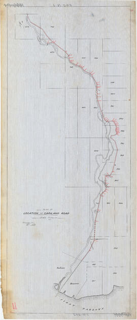
Plan of location of Capilano Road
Part of City of Vancouver fonds
![Plate 163 [Key Plan of North Vancouver]](/uploads/r/null/e/1/d/e1d59c4aba0a20f0522dd57d1ecfbcc6fa0e15d2cb581616d819932b7b4485b7/be98b40c-82d0-4d47-97d2-e5bc54e3e904-1974-100_142.jpg)
Plate 163 [Key Plan of North Vancouver]
Part of City of Vancouver Archives technical and cartographic drawing collection
![Plate 164 [Lonsdale Avenue to Second Street to Chesterfield Avenue to Burrard Inlet]](/uploads/r/null/b/c/5/bc5801cb1cab9f718c08d5e85247acf3c6c6d41621bd633be9636327b722a9cd/db55d2fa-bc36-4407-a98b-9c062774aa12-1974-100_142.jpg)
Plate 164 [Lonsdale Avenue to Second Street to Chesterfield Avenue to Burrard Inlet]
Part of City of Vancouver Archives technical and cartographic drawing collection
![Plate 165 [St. Georges Road to Second Street to Lonsdale Avenue to Burrard Inlet]](/uploads/r/null/7/4/b/74bf056c6f380a72cc2df80556ee1fab18f65d4b16d8d010c950578becb6ee53/d1a63bcb-2baa-4bed-9444-00a74944242c-1974-100_142.jpg)
Plate 165 [St. Georges Road to Second Street to Lonsdale Avenue to Burrard Inlet]
Part of City of Vancouver Archives technical and cartographic drawing collection
![Capilano [River, North] Vancouver](/uploads/r/null/b/7/8/b78f57de17b47bbf531dea7db195235106f1f013de317beed5b8eb10555fab17/2b4d30b1-c99e-4816-8445-60c44448e68c-CVA312-02_142.jpg)
Capilano [River, North] Vancouver
![[Children standing on bridge at] Capilano](/uploads/r/null/b/0/1/b014969ad29bb674ee65ec3b3ff108d57b69782402647cb0bb2cd10a92261979/1f44383a-8c97-4ad8-898d-ebb8998589fa-CVA312-12_142.jpg)
[Children standing on bridge at] Capilano
![[St. Paul's] Catholic Church, North Vancouver](/uploads/r/null/a/9/d/a9d5e679046c5ce5a937351cb63e47b4a8e08a01326e5465b62084fd9df6184d/ffcc2ca5-6132-41ba-aefc-3ac320460151-CVA312-24_142.jpg)
[St. Paul's] Catholic Church, North Vancouver

Capilano Canyon, near Vancouver B.C.
![[Two men and two women posing with bull at Barrow property near Lynn Creek]](/uploads/r/null/0/e/0e6fae5ca38437fd898349f11fb54fb751649b827d0f9a99a83cc7318b91b418/6a714ba0-68de-400b-8d47-6e9bfdd57fbf-A07823_142.jpg)
[Two men and two women posing with bull at Barrow property near Lynn Creek]
Part of Major Matthews collection

A Fallen Giant (Diameter 13 feet) Lynn Valley, B.C.
Part of Major Matthews collection
![[Exterior of John Archibald MacMillan's grocery store and post office]](/uploads/r/null/9/e/9e3009a7fbd517dd23572ae38cbc24392a741e10dacaaed27c89a8ea9d7398c5/f5a95337-b8a3-41cd-80b8-da0913c577cb-A33940_142.jpg)
[Exterior of John Archibald MacMillan's grocery store and post office]
Part of Major Matthews collection
Group portrait showing Glen MacMillan, Mr. Louden, Frank Webber, John Archibald MacMillan and others and Lea MacMillan in the upstairs window

![[Construction on] Lonsdale, first block from First Street (looking east)](/uploads/r/null/b/9/b9efd81fab3f0eeec5a149d52311d1aa24fb5e898bb85ba99080ee2e6ed62c8d/1669c797-6e10-4843-bfea-af49a5ff46d4-A02532_142.jpg)
[Construction on] Lonsdale, first block from First Street (looking east)
Photograph shows people on the street, as well as two men sitting on a cart full of planks next to a building construction site.
![[North Vancouver from Burrard Inlet]](/uploads/r/null/f/2/f285dd5633144f255b287145d9cec78b096827c3110720acace67fe73e7d654a/b97f757f-39e2-4c8f-9352-a095c360e4fe-A02535_142.jpg)
[North Vancouver from Burrard Inlet]
Photograph shows roads, houses, and other buildings near the North Vancouver waterfront.

Capilano Canyon Vancouver, B.C.
Part of Major Matthews collection
Photograph shows the Capilano Suspension Bridge
![[Picnic grounds of North Vancouver Hotel]](/uploads/r/null/8/5/85e295ac3871db585269150adb4de07e0cc93ed2a0391c9351cfac4f381a993b/53a58c2a-ade0-4d15-b512-23804b421ff3-A26341_142.jpg)
[Picnic grounds of North Vancouver Hotel]
Part of Major Matthews collection
![[The Camel Peak on Mount Crown]](/uploads/r/null/3/e/3e4b8464d4decd0f4a3cf24b5ed1a1bdec86eefea0bd6fe22ccf2208cf8962ca/aff56027-c2ff-4eb9-9d8c-e4b07bd0bdb7-A31859_142.jpg)
[The Camel Peak on Mount Crown]
Part of Major Matthews collection
Figure far right identified as R.O. Boult

Capilano Canyon N. Vancouver B.C.
Part of Major Matthews collection
![[View of John J. Woods house on the corner of Second Street and St. Patrick's Avenue]](/uploads/r/null/4/4/441f562ad0bf4f13759b83240355bc715d399438ac5a0e98285d2ac5ae1f6bb3/b7283bd7-1896-486d-b895-f74cd4b7319a-A33952_142.jpg)
[View of John J. Woods house on the corner of Second Street and St. Patrick's Avenue]
Part of Major Matthews collection
![[Henry and Sinclair Barrow, standing in a clearing near Lynn Creek]](/uploads/r/null/0/e/0e4488960223bddb3c2ec5cae7b9cabd14f189543cf4c1951e8442d2e2f5a286/109d1ef8-0952-4ce5-9488-fd215f61e21b-A07822_142.jpg)
[Henry and Sinclair Barrow, standing in a clearing near Lynn Creek]
Part of Major Matthews collection
J.S. Matthews' notes with print or negative in Archives.
![[Exterior of the Hotel Capilano]](/uploads/r/null/9/2/92d3e763c40e78a489acc8b21785bde31e9a2ec10b58916e26c6ed174252dc48/821ff3d7-cf1e-49d2-bb83-44bfb70b37c5-A26334_142.jpg)
[Exterior of the Hotel Capilano]
Part of Major Matthews collection

Part of Major Matthews collection
J.S. Matthews' notes with print or negative in Archives.

![[Shingle bolt flume along Capilano Canyon]](/uploads/r/null/d/1/d191831f93b999bf510e9f99945a966ed3792bfc3a5c9a5ae9897e9fe5c57198/3de3f1fa-3903-4639-977d-95bbb8779af1-A31988_142.jpg)
[Shingle bolt flume along Capilano Canyon]
Part of Major Matthews collection

![Capilano [building]](/uploads/r/null/8/8/e/88e00a9dc2d464a1a695ef94ec71ba5dd52d14cc966a5361b9aa410b58c20376/b87398f5-90e1-4ff3-8435-f4dd90f7c178-CVA312-09_142.jpg)
![[Children standing on bridge at] Capilano](/uploads/r/null/f/6/7/f6768336712ec732b591b1f424f44d4d3752b82e85c6186ac8b62d1a3c4872a7/8d9d90f8-c826-43a1-87ac-a4738c9f439d-CVA312-10_142.jpg)
[Children standing on bridge at] Capilano