![Suck, baby, suck, your Father says it's Sugar! [cartoon]](/uploads/r/null/0/4/5/04521f918884d623b15e7b8e15543d85f130839d52d5ae3f829873edda4200ed/55c20923-485c-4f42-83d0-f574fa28efe1-2011-092_142.jpg)
Suck, baby, suck, your Father says it's Sugar! [cartoon]
- AM1592-1-S5-F020-: 2011-092.2289
- Item
- [1811-1812] (copied 197-?)
Item is a political cartoon which appears to have been cut from a magazine.
214058 results with digital objects Show results with digital objects
Suck, baby, suck, your Father says it's Sugar! [cartoon]
Item is a political cartoon which appears to have been cut from a magazine.
Part of City of Vancouver Archives technical and cartographic drawing collection
Item is a map showing "Mr. Stuart's route through the United States, and Canada in 1828, 29 & 30" and "the boundary of the United States, both on the side of the British Possessions, & those in Mexico." The northern border of United States territory west of the Rocky Mountains is incorrectly noted at 54/40, to reflect American claims of the time.

Part of City of Vancouver Archives technical and cartographic drawing collection
Item is a map depicting the territory that was part of British North America in 1834. The map depicts geographical features, forts and trading posts, factories and cities. The map was compiled from Hudson's Bay Company records of Parry, Franklin, Beechey, and Graab.

British possessions in North America
Part of City of Vancouver Archives technical and cartographic drawing collection
Item is a map showing British territories and borders with Russian territories, the United States, and Mexico. Includes White population totals for Hudson Bay territory, Upper Canada, Lower Canada, New Brunswick, Nova Scotia, Cape Breton Is., Prince Edward Is., and Newfoundland as well as white population for United States claimed territory, broken down by state.
![[67th South Hampshire Regiment]](/uploads/r/null/1/c/1c093d0d8eccca9b84f28801f319d789a67549e7cefe0ecc8b9918910a0b84d9/573037b2-90a1-4e66-953c-00f693595940-A32352_142.jpg)
[67th South Hampshire Regiment]
Part of Major Matthews collection
Group portrait
![[67th South Hampshire Regiment]](/uploads/r/null/f/f/ffa85189440fd185ed26f7c28279060ea16332c5c9afc0841d7836504e3b5971/9aefc90d-4edd-43d0-a846-2cccc21b605b-A32353_142.jpg)
[67th South Hampshire Regiment]
Part of Major Matthews collection
Group portrait in front of a log building
![[Cross sections of ocean floor between Vancouver Island and mainland of British Columbia]](/uploads/r/null/c/a/6/ca687b43e46696a0c1d9223ef1e80ebe50bba0ea48092c458b525fc90f7b517c/7d458083-64ae-4682-be03-8fd1211e38c9-MAP8b_142.jpg)
[Cross sections of ocean floor between Vancouver Island and mainland of British Columbia]
Part of City of Vancouver Archives technical and cartographic drawing collection
Item shows ocean floor cross sections at 49 degrees latitude, 48 degrees 45', 48 degrees 35', and 48 degrees 25'. Islands and other geographical features are indicated.
Map showing the line of boundary between the United States and British possessions
Part of City of Vancouver Archives technical and cartographic drawing collection
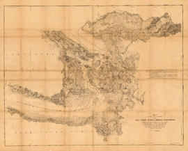
Item is a map showing four proposed boundaries between the United States and British possessions in the Salish Sea region. The explanations of the lines read in part: "[1] Boundary line contemplated by the Treaty as shown by contemporaneous evidence; [2] Boundary line as claimed by the British Commissioner; [3] Boundary line proposed by the British Commissioner as a compromise ( . . . ); [4] Boundary line in accordance with the strict letter of the Treaty ( . . . ). Item also shows soundings, and the "track of steamers plying between Victoria and Fraser river since discovery of gold."

Chart of the eastern Pacific Ocean
Part of City of Vancouver Archives technical and cartographic drawing collection

Sugar Mill at work, West Indies 1849

Vancouver Island and Gulf of Georgia
Part of City of Vancouver Archives technical and cartographic drawing collection
Item is a reproduction of a nautical chart with illustrations. Illustrations depict a view of Nootka Sound, a view of Cape Alava and Cape Flattery, and the entrance to the Straits of Juan de Fuca.

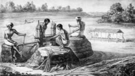
Cane Holeing (slave labour), West Indies 1849
Margaret (Wilson) Hendry : mother of John Hendry
Part of Hamber family fonds

Part of Major Matthews collection
![[Major General Rogers]](/uploads/r/null/a/3/a333117c00981139680e76a0e8aedc2cd65e70482f18e1975e8b65a4652cb3bd/f2392132-8a65-4033-985b-cec709296a81-A34506_142.jpg)
Part of Major Matthews collection
Studio portrait

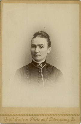
Portrait of unidentified woman
Part of Hamber family fonds

Mrs. Hendry : grandmother of John Hendry
Part of Hamber family fonds

Margaret (Wilson) Hendry : mother of John Hendry
Part of Hamber family fonds

Part of Major Matthews collection
![[Railway yards] immediately below Keefer's house](/uploads/r/null/c/a/ca56324326d41d166dd0db141089c83221c7869a20d0cab1e7ca7098540254f1/68e97b63-8e1b-47cf-b430-980eaeb0e409-A25449_142.jpg)
[Railway yards] immediately below Keefer's house
Part of Major Matthews collection

Part of Hamber family fonds
![[Studio portrait of James Clephan and his niece Mary C. Elgood]](/uploads/r/null/3/e/3e1c721df90e310e5052ff6ec43b23755ae75a94bd038ec5ddf121703b67a127/902152e1-83d9-4347-b495-6e243e2eecde-A02349_142.jpg)
[Studio portrait of James Clephan and his niece Mary C. Elgood]
![[Twitchell family portrait]](/uploads/r/null/f/2/f2d141cc606e9875f8a6602813d801ade06e7a7f12215d049cefdade59848930/5eb2c486-7605-495e-ab38-b2562f57e4e6-CVA1477-434_142.jpg)
Part of L.D. Taylor family fonds
Photograph is a studio portrait showing Caroline Little Twitchell, later Caroline Little Pierce, (standing) with her mother and siblings.

Part of Major Matthews collection
Item is a copy of a portion of a manuscript map of Burrard Inlet, created during the H.M.S. Plumper survey of the area. Sheet shows the eastern portion of the Inlet, including the southern portion of the North Arm.
United Kingdom. Admiralty
![[Full length studio portrait of] Mrs. William (Smith) Cruise](/uploads/r/null/7/1/71f71400c2bdefd36af8e77d542cba6fe342db89542c9756f73e49e61c215e3e/925157ed-ac31-4e4c-ad57-ced2c0842510-A02348_142.jpg)
[Full length studio portrait of] Mrs. William (Smith) Cruise

Part of City of Vancouver Archives technical and cartographic drawing collection
Item is a photostat copy of a portion of a map of Burrard Inlet from the 1859 H.M.S. Plumper Survey. The map depicts outer Burrard Inlet and the surrounding shorlines.
![[Louis Oppenheimer]](/uploads/r/null/3/4/3482369edf79bbdb30229039b17fb9847e9fcd8bd800d260ad552bf54e4dd8b1/ad7c41a9-e7b4-466b-90b2-77f7d55a689a-A35822_142.jpg)
Part of Major Matthews collection
Studio portrait
Part of Hamber family fonds

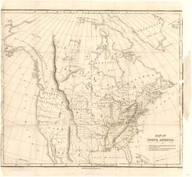
Map of the United States and territories together with Canada etc.
Part of City of Vancouver Archives technical and cartographic drawing collection
Item is a map showing the boundaries of U.S. territories and states and the southern portion of Canadian colonies of Vancouver Island, British Columbia, Canada East, Canada West, as well as New Brunswick, Prince Edward Island and Nova Scotia. The map also shows cities and principal geographical features. Two inset maps show "Hampton Roads and Norfolk Harbour" and "Pensacola Bay" in greater detail.

Map of a portion of British Columbia
Part of City of Vancouver Archives technical and cartographic drawing collection
Item is a map showing exploration routes by Lieutenant Palmer, R.E., May and June 1859; Lieutenant Mayne, R.N., May 1859; and Lieutenant Palmer, R.E., Sept. & Oct. 1859. The map also shows "practicable roads" in the southwestern portion of British Columbia. Annotations are colour added to the map to more easily distinguish the different routes depicted.
Part of Hamber family fonds
![[Osborne J. Pierce]](/uploads/r/null/2/3/237c61c9ad88467482f99b90469506e254687c51197d822d142c82dc52cf1b1e/a71e515c-3934-431f-9ca2-abcc0ddea5dc-CVA1477-435_142.jpg)
Part of L.D. Taylor family fonds
Full-length studio portrait.


Portrait of Alexander Godfrey (left) and Chris Godfrey
Part of Alexander Godfrey fonds

Portrait of unidentified woman
Part of Hamber family fonds
![[Portrait of young woman]](/uploads/r/null/0/7/0718aea0d074adceb65a1fe8eb9a83e90636cb10ea9fa30cba9a02ad58b961c1/cfa0469e-a1ea-4866-acf5-55ba21813e80-A01843_142.jpg)
"Jennie" has been written in the upper right corner of the photograph in pencil.

Map showing the line of boundary between the United States & British possessions
Part of Major Matthews collection
![[Mrs. Benjamin Springer (nee Frances Nias)]](/uploads/r/null/c/a/ca224d65615780f4d8db5b187e45a1ca4c1fe491e81acf2c4b841e6883315c99/7464c91c-c001-4588-bfc5-f425b0f080dc-A34654_142.jpg)
[Mrs. Benjamin Springer (nee Frances Nias)]
Part of Major Matthews collection
Head and shoulders portrait
![Family home about 1860: Samuel Rogers, father of B.T. [Benjamin Tingley]](/uploads/r/null/b/d/9/bd9b3292c97579705ac4901524e8a4c8f9f68f09b5bf73906a4e53ad7331be1f/53a63c82-c73d-4d8f-a8f4-f594b5fb981a-2011-092_142.jpg)
Family home about 1860: Samuel Rogers, father of B.T. [Benjamin Tingley]
![[Studio portrait of] Queen Victoria and Prince Albert](/uploads/r/null/5/3/53c221c69324f41995a43bf139f40583e568effd9407e2e6d2a68976583552e7/5643ee3f-2936-4a96-8d0c-d4ad3314286a-A02238_142.jpg)
[Studio portrait of] Queen Victoria and Prince Albert
![Sketch of part of proposed line of waggon [sic] road from "Boston Bar" to "Yale&qu...](/uploads/r/null/c/e/2/ce2401c4feac301ae2c09b558486e5d36c42075bdbdb34d93491fb38bf94199b/a0d055f2-d790-4fc6-b0aa-1572524f65c8-LEG1800_142.jpg)
Part of City of Vancouver Archives technical and cartographic drawing collection
Item is a map depicting survey data for a proposed wagon road from Boston Bar to Yale along the Fraser River". The map shows various landmarks and habitation, and includes construction details.
![Sketch of part of line of waggon [sic] road from "Boston Bar" to "Yale"](/uploads/r/null/6/8/5/685aeba6eb70cf489e3dc55456603ed30b0d42c00326cb69f8eb8fa758e030aa/714b3ee8-af5a-4786-85f4-230287a8d5fa-LEG1800_142.jpg)
Sketch of part of line of waggon [sic] road from "Boston Bar" to "Yale"
Part of City of Vancouver Archives technical and cartographic drawing collection
Item is a map depicting survey data for a proposed wagon road from Boston Bar to Yale along the Fraser River". The map shows various landmarks and habitation, and includes construction details.

Sketch of part of line of road along right bank of "Fraser River" from "Boston Bar" to "Yale"
Part of City of Vancouver Archives technical and cartographic drawing collection
Item is a map depicting survey data for a proposed wagon road from Boston Bar to Yale along the Fraser River". The map shows various landmarks and habitation, and includes construction details.

Haro Strait and middle channel
Part of City of Vancouver Archives technical and cartographic drawing collection
Item is a reproduction of a nautical chart of Haro Strait and middle channel between Vancouver Island and the mainland.

Map of Esquimalt, showing location of Royal Hospital
Part of Major Matthews collection
Item is a photostat copy of an 1869 tracing of a map created during or after the survey of George Henry Richards, R.N. of H.M.S. Hecate.

Mary McCleery and brother Samuel McCleery
Part of McCleery family fonds
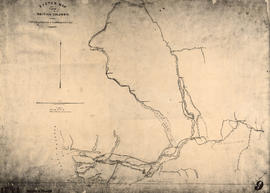
Sketch map of part of British Columbia showing trails and routes of communication
Part of Major Matthews collection
Item is a photostatic copy of a manuscript map showing trails and routes of communication in a portion of British Columbia from the Canada-U.S. border in the south to Seaton Lake in the north, and from the coast to Vermillion in the east. The section of coastline extends from Semiahmoo Bay in the south to Point Atkinson in the north. Map shows the location of mule trails and wagon roads, and includes a trail in progress from New Westminster to Burrard Inlet (North Road), trails from Whatcom to Hope and Semiahmoo to Derby, the Hudsons Bay Brigade Trail, Douglas Road, a trail proposed by Colonel Moody from New Westminster to Fort Hope, and the Dewdney Trail. Included with the map is a 1949 letter from Major Matthews, City Archivist, to J.M. Pearce in which Matthews describes the map, and a 1952 enquiry from L.B. [Housler] for a map showing the Dewdney Trail.

Part of City of Vancouver Archives technical and cartographic drawing collection
Item is a re-published version of a geographical map originally published by the Colony of British Columbia, Office of Lands and Works. The map shows topography as hacheurs, and depicts fur trade trails and forts and physical features of the area which made up the Colony of British Columbia as of 1862.