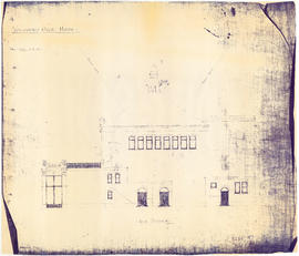
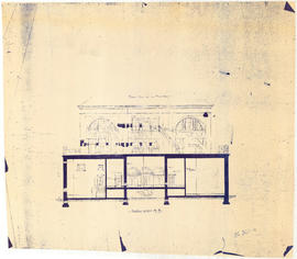
Vancouver Opera House half elevation of street front
Canadian Pacific map of Vancouver [west half]
Vancouver Opera House plan of balcony
Vancouver Opera House plan of gallery
Vancouver Opera House transverse section
Vancouver Opera House side elevation
192 : plan of Provincial Government property being a portion of Townsite of Vancouver and subdivision of Lot 540 Group 1, New Westminster District, B.C., to be sold by public auction
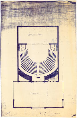
Vancouver Opera House ground floor plan
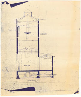
Vancouver Opera House longitudinal section
City of Vancouver. Fifth Sale. Lots and blocks in Lot 540
Vancouver Opera House section on line C-D
Plan of part of subdivision of district lot 540. South Vancouver
Vancouver Opera House basement plan
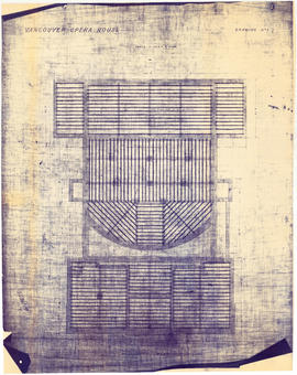
Vancouver Opera House plan of roof timbers
Vancouver Opera House section on line A-B
Map of part of the New Westminster District shewing the proposed new municipality of Burnaby
City of Vancouver. Canadian Pacific town site
Plan of the City of Vancouver. Western Terminus of the Canadian Pacific Railway
Vancouver, B.C., Pacific terminus of the C.P.R.
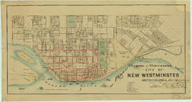
City of New Westminster British Columbia
Map of New Westminster District, B.C.
Burrard Inlet
Plan of system of sewerage for the city of New Westminster, British Columbia
Distribution system of waterworks, City of New Westminster, British Columbia
Stuart's pocket map of Vancouver, B.C.
North America - West Coast. British Columbia. Burrard Inlet
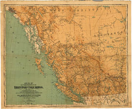
Map of the Province of British Columbia
City of Vancouver
Plan of subdivision of D in lot 183 and subdivision of J in lot 182, City of Vancouver
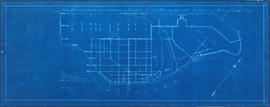
[Map of Pioneer Place showing the area deeded to the City of Vancouver by the C.P.R.]
Vancouver City : plan of Subdivision of lot 301, Group 1, New Westminster District
Map of the Lower Mainland district of British Columbia
Tourist guide map of Vancouver City and park
Panoramic view of the City of Vancouver, British Columbia, 1898
Tourist guide map of Vancouver City and Park
Map of the business portion of the City of Vancouver, British Columbia [early street paving]
Plan of the townsite of North Vancouver
Map of Vancouver, New Westminster, Steveston and the Lower Mainland District
Municipality of North Vancouver [Burrard Inlet]
New Westminster waterworks : plan of city distribution system
Plan of Provincial Government property being a portion of Townsite of Vancouver
Plan of part of D.L. 540
Plan of the Burrard Inlet and Pitt River canal location
Plan of the City of Vancouver
Plan of town of Lonsdale : situate [sic] on harbour opposite City of Vancouver
Plate A [Index map of Vancouver - western portion]
Plate 105 [Front Street to False Creek to Quebec Street to Dufferin Street]
Plate 107 [Quebec Street to Dufferin Street to Manitoba Street to Fifth Avenue]
Plate 108 [Scotia Street to Front/Dufferin Streets to Quebec Street to Fifth Avenue]


![Canadian Pacific map of Vancouver [west half]](/uploads/r/null/f/a/fa49266d21715d75ce93883012d471657dd058b90843927ec82b44d2bb42b007/f12ea9a5-4914-4db8-bda9-312aa2e2ccef-MAP10_142.jpg)


![[Map of Pioneer Place showing the area deeded to the City of Vancouver by the C.P.R.]](/uploads/r/null/4/1/41ba387b96586eb8554abcbf013c0e5cfbb116a42c8d1d1d2311fb1856694b2a/e3bd79d3-cd72-42e4-aa51-bc080514c205-MAP780_142.jpg)


![Map of the business portion of the City of Vancouver, British Columbia [early street paving]](/uploads/r/null/7/1/7187f671d2770050eb87f7f397a10ea92bf0bc593b0a186e3a4bf341b3d26e42/8770145a-b925-4eef-82ac-e397f61a65aa-Map1163_142.jpg)


![Municipality of North Vancouver [Burrard Inlet]](/uploads/r/null/6/d/6d0d9a4b75b38672c56aa89a5984fe2d0e6d66be85f6f375cbe8e2fd7ac94a98/577914e1-3de2-478b-a629-5f391731387a-MAP588_142.jpg)


![Plan of town of Lonsdale : situate [sic] on harbour opposite City of Vancouver](/uploads/r/null/c/5/d/c5d4b56db1d7f9e1cf57dd5a974f6fcb23507e64543bad1bdd8f62139042389f/1cc57eaf-6c92-438e-a65d-335940738df7-MAP686_142.jpg)
![Plate A [Index map of Vancouver - western portion]](/uploads/r/null/0/d/0/0d022ba039f0508a397a4d35450b667671f0ef36fd388f800f51681434d2a2a9/795dc4f4-e794-4288-880d-6bd4de616417-1974-100_142.jpg)
![Plate 105 [Front Street to False Creek to Quebec Street to Dufferin Street]](/uploads/r/null/a/f/b/afbb9be25514350d408eefa5865173e3a489ecdb6752d6b3096564052b234ca4/8c126ea6-16bb-4f0b-8131-a16f2a686d95-1974-100_142.jpg)
![Plate 107 [Quebec Street to Dufferin Street to Manitoba Street to Fifth Avenue]](/uploads/r/null/0/d/7/0d79d0f2e59b2acf6f0b094b86112948aced989bd8c13eb8f8ac17f5cb05a1fd/b74906fe-c1a9-49b1-8bc5-37b4141108f6-1974-100_142.jpg)
![Plate 108 [Scotia Street to Front/Dufferin Streets to Quebec Street to Fifth Avenue]](/uploads/r/null/5/4/6/54625ed1d1a99824d0a91f9897950dc4d1691ce8f7fae7be8086e768e671ef0e/5da48b46-8a62-40b9-9992-0fcbe4e8b491-1974-100_142.jpg)