
- AM54-S13-: LEG1801.033
- Item
- [ca. 1850?] (copied 195-?)
Part of Major Matthews collection
Part of Major Matthews collection

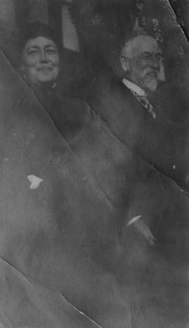
Portrait of unidentified woman
Part of Hamber family fonds

Mrs. Hendry : grandmother of John Hendry
Part of Hamber family fonds
![[Major General Rogers]](/uploads/r/null/a/3/a333117c00981139680e76a0e8aedc2cd65e70482f18e1975e8b65a4652cb3bd/f2392132-8a65-4033-985b-cec709296a81-A34506_142.jpg)
Part of Major Matthews collection
Studio portrait

Margaret (Wilson) Hendry : mother of John Hendry
Part of Hamber family fonds

Part of Major Matthews collection
![[Railway yards] immediately below Keefer's house](/uploads/r/null/c/a/ca56324326d41d166dd0db141089c83221c7869a20d0cab1e7ca7098540254f1/68e97b63-8e1b-47cf-b430-980eaeb0e409-A25449_142.jpg)
[Railway yards] immediately below Keefer's house
Part of Major Matthews collection

Part of Hamber family fonds
![[Studio portrait of James Clephan and his niece Mary C. Elgood]](/uploads/r/null/3/e/3e1c721df90e310e5052ff6ec43b23755ae75a94bd038ec5ddf121703b67a127/902152e1-83d9-4347-b495-6e243e2eecde-A02349_142.jpg)
[Studio portrait of James Clephan and his niece Mary C. Elgood]
![[Twitchell family portrait]](/uploads/r/null/f/2/f2d141cc606e9875f8a6602813d801ade06e7a7f12215d049cefdade59848930/5eb2c486-7605-495e-ab38-b2562f57e4e6-CVA1477-434_142.jpg)
Part of L.D. Taylor family fonds
Photograph is a studio portrait showing Caroline Little Twitchell, later Caroline Little Pierce, (standing) with her mother and siblings.

Part of Major Matthews collection
Item is a copy of a portion of a manuscript map of Burrard Inlet, created during the H.M.S. Plumper survey of the area. Sheet shows the eastern portion of the Inlet, including the southern portion of the North Arm.
United Kingdom. Admiralty
![[Full length studio portrait of] Mrs. William (Smith) Cruise](/uploads/r/null/7/1/71f71400c2bdefd36af8e77d542cba6fe342db89542c9756f73e49e61c215e3e/925157ed-ac31-4e4c-ad57-ced2c0842510-A02348_142.jpg)
[Full length studio portrait of] Mrs. William (Smith) Cruise

Part of City of Vancouver Archives technical and cartographic drawing collection
Item is a photostat copy of a portion of a map of Burrard Inlet from the 1859 H.M.S. Plumper Survey. The map depicts outer Burrard Inlet and the surrounding shorlines.
![[Louis Oppenheimer]](/uploads/r/null/3/4/3482369edf79bbdb30229039b17fb9847e9fcd8bd800d260ad552bf54e4dd8b1/ad7c41a9-e7b4-466b-90b2-77f7d55a689a-A35822_142.jpg)
Part of Major Matthews collection
Studio portrait
Part of Hamber family fonds
Part of Hamber family fonds
![[Osborne J. Pierce]](/uploads/r/null/2/3/237c61c9ad88467482f99b90469506e254687c51197d822d142c82dc52cf1b1e/a71e515c-3934-431f-9ca2-abcc0ddea5dc-CVA1477-435_142.jpg)
Part of L.D. Taylor family fonds
Full-length studio portrait.

Map of the United States and territories together with Canada etc.
Part of City of Vancouver Archives technical and cartographic drawing collection
Item is a map showing the boundaries of U.S. territories and states and the southern portion of Canadian colonies of Vancouver Island, British Columbia, Canada East, Canada West, as well as New Brunswick, Prince Edward Island and Nova Scotia. The map also shows cities and principal geographical features. Two inset maps show "Hampton Roads and Norfolk Harbour" and "Pensacola Bay" in greater detail.

Map of a portion of British Columbia
Part of City of Vancouver Archives technical and cartographic drawing collection
Item is a map showing exploration routes by Lieutenant Palmer, R.E., May and June 1859; Lieutenant Mayne, R.N., May 1859; and Lieutenant Palmer, R.E., Sept. & Oct. 1859. The map also shows "practicable roads" in the southwestern portion of British Columbia. Annotations are colour added to the map to more easily distinguish the different routes depicted.

Portrait of Alexander Godfrey (left) and Chris Godfrey
Part of Alexander Godfrey fonds

Portrait of unidentified woman
Part of Hamber family fonds

![[Portrait of young woman]](/uploads/r/null/0/7/0718aea0d074adceb65a1fe8eb9a83e90636cb10ea9fa30cba9a02ad58b961c1/cfa0469e-a1ea-4866-acf5-55ba21813e80-A01843_142.jpg)
"Jennie" has been written in the upper right corner of the photograph in pencil.
![[Mrs. Benjamin Springer (nee Frances Nias)]](/uploads/r/null/c/a/ca224d65615780f4d8db5b187e45a1ca4c1fe491e81acf2c4b841e6883315c99/7464c91c-c001-4588-bfc5-f425b0f080dc-A34654_142.jpg)
[Mrs. Benjamin Springer (nee Frances Nias)]
Part of Major Matthews collection
Head and shoulders portrait

Map showing the line of boundary between the United States & British possessions
Part of Major Matthews collection
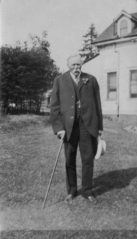
![Family home about 1860: Samuel Rogers, father of B.T. [Benjamin Tingley]](/uploads/r/null/b/d/9/bd9b3292c97579705ac4901524e8a4c8f9f68f09b5bf73906a4e53ad7331be1f/53a63c82-c73d-4d8f-a8f4-f594b5fb981a-2011-092_142.jpg)
Family home about 1860: Samuel Rogers, father of B.T. [Benjamin Tingley]
![[Studio portrait of] Queen Victoria and Prince Albert](/uploads/r/null/5/3/53c221c69324f41995a43bf139f40583e568effd9407e2e6d2a68976583552e7/5643ee3f-2936-4a96-8d0c-d4ad3314286a-A02238_142.jpg)
[Studio portrait of] Queen Victoria and Prince Albert
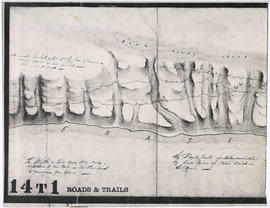
![Sketch of part of proposed line of waggon [sic] road from "Boston Bar" to "Yale&qu...](/uploads/r/null/c/e/2/ce2401c4feac301ae2c09b558486e5d36c42075bdbdb34d93491fb38bf94199b/a0d055f2-d790-4fc6-b0aa-1572524f65c8-LEG1800_142.jpg)
Part of City of Vancouver Archives technical and cartographic drawing collection
Item is a map depicting survey data for a proposed wagon road from Boston Bar to Yale along the Fraser River". The map shows various landmarks and habitation, and includes construction details.
![Sketch of part of line of waggon [sic] road from "Boston Bar" to "Yale"](/uploads/r/null/6/8/5/685aeba6eb70cf489e3dc55456603ed30b0d42c00326cb69f8eb8fa758e030aa/714b3ee8-af5a-4786-85f4-230287a8d5fa-LEG1800_142.jpg)
Sketch of part of line of waggon [sic] road from "Boston Bar" to "Yale"
Part of City of Vancouver Archives technical and cartographic drawing collection
Item is a map depicting survey data for a proposed wagon road from Boston Bar to Yale along the Fraser River". The map shows various landmarks and habitation, and includes construction details.

Sketch of part of line of road along right bank of "Fraser River" from "Boston Bar" to "Yale"
Part of City of Vancouver Archives technical and cartographic drawing collection
Item is a map depicting survey data for a proposed wagon road from Boston Bar to Yale along the Fraser River". The map shows various landmarks and habitation, and includes construction details.

Haro Strait and middle channel
Part of City of Vancouver Archives technical and cartographic drawing collection
Item is a reproduction of a nautical chart of Haro Strait and middle channel between Vancouver Island and the mainland.

Map of Esquimalt, showing location of Royal Hospital
Part of Major Matthews collection
Item is a photostat copy of an 1869 tracing of a map created during or after the survey of George Henry Richards, R.N. of H.M.S. Hecate.

Mary McCleery and brother Samuel McCleery
Part of McCleery family fonds
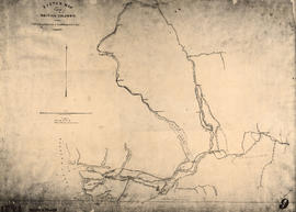
Sketch map of part of British Columbia showing trails and routes of communication
Part of Major Matthews collection
Item is a photostatic copy of a manuscript map showing trails and routes of communication in a portion of British Columbia from the Canada-U.S. border in the south to Seaton Lake in the north, and from the coast to Vermillion in the east. The section of coastline extends from Semiahmoo Bay in the south to Point Atkinson in the north. Map shows the location of mule trails and wagon roads, and includes a trail in progress from New Westminster to Burrard Inlet (North Road), trails from Whatcom to Hope and Semiahmoo to Derby, the Hudsons Bay Brigade Trail, Douglas Road, a trail proposed by Colonel Moody from New Westminster to Fort Hope, and the Dewdney Trail. Included with the map is a 1949 letter from Major Matthews, City Archivist, to J.M. Pearce in which Matthews describes the map, and a 1952 enquiry from L.B. [Housler] for a map showing the Dewdney Trail.
![[Full length studio portrait of] John Woolsey](/uploads/r/null/a/f/af5720e477d9072c3383876a2c8b977e2f9335444842deecbb4de8240deea9a8/1fa39eda-b6aa-479e-97af-172a0b94e8aa-A02517_142.jpg)
[Full length studio portrait of] John Woolsey

Part of City of Vancouver Archives technical and cartographic drawing collection
Item is a re-published version of a geographical map originally published by the Colony of British Columbia, Office of Lands and Works. The map shows topography as hacheurs, and depicts fur trade trails and forts and physical features of the area which made up the Colony of British Columbia as of 1862.
![Country lands, New Westminster District [D.L. 185]](/uploads/r/null/2/f/f/2ff00fcb19a3dd23ff02f3355264a2fef808da9c2362a01bc084c87c334bbb27/0143c5f1-96bf-4733-b1d3-2386ba496659-LEG1801_142.jpg)
Country lands, New Westminster District [D.L. 185]
Part of Major Matthews collection
Unidentified portion of Fraser River shoreline
Part of City of Vancouver Archives technical and cartographic drawing collection
Item is a copy of a portion of a surveying map depicting an unidentified portion of the Fraser River. The map shows trails and a wagon road along the Fraser River and contains notes about the topography and vegetation.

Esther McCleery and brother Fitzgerald McCleery
Part of McCleery family fonds

Sketch map of part of British Columbia showing trails and routes of communication
Part of Major Matthews collection
Item is a photostatic copy of a manuscript map showing trails and routes of communication in a portion of British Columbia from the Canada-U.S. border in the south to Seaton Lake in the north, and from the coast to Vermillion in the east. The section of coastline extends from Semiahmoo Bay in the south to Point Atkinson in the north. Map shows the location of mule trails and wagon roads, and includes a trail in progress from New Westminster to Burrard Inlet (North Road), trails from Whatcom to Hope and Semiahmoo to Derby, the Hudsons Bay Brigade Trail, Douglas Road, a trail proposed by Colonel Moody from New Westminster to Fort Hope, and the Dewdney Trail. Included with the map is a 1949 letter from Major Matthews, City Archivist, to J.M. Pearce in which Matthews describes the map, and a 1952 enquiry from L.B. [Housler] for a map showing the Dewdney Trail.
![D.L. 184 westward to [D.L. 181?]](/uploads/r/null/d/6/6/d66e699892f5f3573732fab74345928c93375400f48a564db38b4128d7809aa6/10ea8d79-243c-45ea-99f9-60f17d329c2c-LEG1801_142.jpg)
D.L. 184 westward to [D.L. 181?]
Part of Major Matthews collection
Item is one of three tracings of sketches from a foreshore survey conducted by the Royal Engineers (Sappers Breakenridge, Patterson and Goskirk, under Lance Corporal G. Turner), who surveyed the foreshore from Hastings Sawmill west to Coal Harbour and the

Part of Major Matthews collection
Item is one of three tracings of sketches from a foreshore survey conducted by the Royal Engineers (Sappers Breakenridge, Patterson and Goskirk, under Lance Corporal G. Turner), who surveyed the foreshore from Hastings Sawmill west to Coal Harbour and the

Part of Major Matthews collection
Item is one of three tracings of sketches from a foreshore survey conducted by the Royal Engineers (Sappers Breakenridge, Patterson and Goskirk, under Lance Corporal G. Turner), who surveyed the foreshore from Hastings Sawmill west to Coal Harbour and the

North America. West Coast. Fraser River and Burrard Inlet
Part of City of Vancouver Archives technical and cartographic drawing collection
Item is a nautical chart which show details of area surveyed from Pitt Lake in the north to Roberts Bank in the south and from (what is now) Harrison Hot Springs in the east to Bowen Island in the west. The chart shows soundings in Burrard Inlet, and along the Fraser River.

Part of City of Vancouver Archives technical and cartographic drawing collection
Item is a modern photocopy of a map showing the southwest portion of British Columbia and the northwest part of Washington State. The map depicts settlements, geographical features, wagon roads, bridle paths and other man-made features. Prepared under the direction of Capt. Persona, R.E. by order of Col. R.C. Moody, R.E.
![[View of the Thompson River east of Lytton]](/uploads/r/null/b/5/b57bdc9554f4c089b187d1c5f5b233acbf931272e64dad2a0b54dd28040149cf/21978601-2e31-4d42-983f-3d601c619e55-A33843_142.jpg)
[View of the Thompson River east of Lytton]
Part of Major Matthews collection
![[View of Yale from across the river]](/uploads/r/null/d/8/d88bb63c674fa01155005f050b7f8d2ee6d5c424265116251dcf4dda08e4b73c/32c5ed3b-5b71-4c9d-8738-671a1fb58eef-A33844_142.jpg)
[View of Yale from across the river]
Part of Major Matthews collection
![The Cameron C[ompanies?] claim "Camerouton" Williams Creek, B.C.](/uploads/r/null/5/8/586bbd218cda2979c8a18a35132229376962b6000903d6a90345763e5f4917c4/cc30a9b4-062f-43eb-b1e8-aaebd3631afd-A26627_142.jpg)
The Cameron C[ompanies?] claim "Camerouton" Williams Creek, B.C.
Part of Major Matthews collection
Photograph shows John A. Cameron, known as "Cariboo Cameron", with mining equipment and structures.
![[View of Spences Bridge]](/uploads/r/null/f/d/fde21c3df95bc8ea353a096dfa36a64257e960c089734510aecbf780ba673c38/905a7d1e-4b81-48f2-a730-cf093778e339-A33845_142.jpg)
Part of Major Matthews collection
![[A part of the Cariboo Road between Hell's Gate and Chapmans]](/uploads/r/null/0/9/09f564a5e10bf8b5b528d6cef608078781396fb613caaf73894b7adb3890e28a/20f81bdb-6c16-431f-a020-ec7dbd161749-A33841_142.jpg)
[A part of the Cariboo Road between Hell's Gate and Chapmans]
Part of Major Matthews collection