
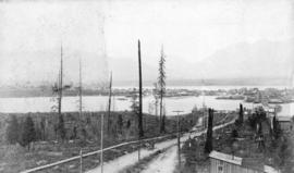
Tunnel No. 2 and Yale looking down valley from far side of river
- AM1376-: CVA 3-6
- Item
- [188-?]
1392 results with digital objects Show results with digital objects
Tunnel No. 2 and Yale looking down valley from far side of river

Part of Major Matthews collection
Photograph shows a view loking north from the corner of Westminster Avenue (Main Street) and 7th Avenue including the Westminster Avenue Trestle Bridge and False Creek in the background
![From Park Road, Showing Mission [in North] Vancouver](/uploads/r/null/e/a/ea84794d38d5194b79fb6f1d973a13b703523d6a784b302853d965a53b82552c/300ce682-c55a-4925-9c09-1f6f96286f95-A36844_142.jpg)
From Park Road, Showing Mission [in North] Vancouver
Part of Major Matthews collection
Vancouver, B.C. from the South
Part of Major Matthews collection
Photograph shows a view looking north from the corner of Westminster Avenue (Main Street) and 7th Avenue including the Westminster Avenue Trestle Bridge and False Creek in the background
![[View of the First Narrows from Prospect Point]](/uploads/r/null/2/4/2496bc3c3b2491d87867e8b7c1117429fd97eea7916ae21c6d58077e7537b5d6/754565dd-6029-4205-b5db-2ed739f5761c-A36785_142.jpg)
[View of the First Narrows from Prospect Point]
Part of Major Matthews collection

Part of Major Matthews collection

Hope Mountains from Hope Station
Part of Major Matthews collection
![[Looking south across False Creek from Hamilton Street and Robson Street]](/uploads/r/null/f/b/fbe06b66c9466b7b0d3b9b5ecd6ff870225ca2e783b16af2327f55a49d950914/bd074e06-7935-4238-87a0-1fa1e0f8fac8-A37083_142.jpg)
[Looking south across False Creek from Hamilton Street and Robson Street]
Part of Major Matthews collection
![[View of North Vancouver from across Burrard Inlet]](/uploads/r/null/f/3/f3f3752f66509bf91857f1790e0ef7e59de6f1125cf77326c5529552883a1768/d3c54dd1-21f8-4c66-9168-2d130918fd9b-A32575_142.jpg)
[View of North Vancouver from across Burrard Inlet]
Part of Major Matthews collection
Panoramic view

Grand Medley of British Columbia Scenery
Part of Major Matthews collection
Photograph shows approximately 35 images from various locations throughout British Columbia
![[Looking north across False Creek from 8th Avenue between Alder Street and Spruce Street]](/uploads/r/null/b/f/bfbfdda073909ac3a8b7fe81c7d8a986770772ac8fdcfef25af14dca17a87a19/d7b8ac67-cd53-4df6-a8a2-3c59dcd146d8-A43223_142.jpg)
[Looking north across False Creek from 8th Avenue between Alder Street and Spruce Street]
Part of Major Matthews collection
Panoramic view showing Yaletown and the Fader Brothers sawmill
![[Looking west across False Creek from 7th Avenue and Birch Street]](/uploads/r/null/3/1/313ac14834d7064a141c7918b538a6c9c79ce7026237e479c697a3d0e4703dd4/1508bee7-942a-4268-94da-1baf5abecc12-A43222_142.jpg)
[Looking west across False Creek from 7th Avenue and Birch Street]
Part of Major Matthews collection
Panoramic view showing Granville Street Bridge and the C.P.R. Kitsilano Trestle Bridge

Medecine Hat and Saskatchewan River
Part of Major Matthews collection
![[View of] Sandon, B.C.](/uploads/r/null/3/b/a/3ba421a62d2d82ea7bd602874df58ead946686c73ed0e18a64a79f02c92cc883/16a9bd4f-57ec-4f04-a63c-6f4bb450ec48-CVA256-02_142.jpg)
Part of Elizabeth Abbott fonds

Banff National Park from Cave Hot Springs
Looking Across the Inlet from Hotel Vancouver
Photograph shows a view looking north from Georgia Street showing the west side of the 600 Block Howe Street including Manor House and beyond to Deadman's Island

Moodyville Milling Company's Mills, Moodyville, B.C.

Mount Sir Donald, C.P.R. Selkirks, Height 10,645 feet

Victoria, B.C. from Government Buildings

Vancouver, B.C. from Mount Pleasant
Part of Major Matthews collection
Photograph shows a view north along Westminster Avenue (Main Street) with the bridge, False Creek and Downtown in the background

Silver Mountain, Harrison Lake
Part of Major Matthews collection

Part of Major Matthews collection
Photograph shows a view of Hope from across the river

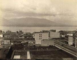
Vancouver, B.C. from Hotel Vancouver
Part of Major Matthews collection
Photograph shows a northeast view of the 600 Block Granville Street including the New York Block, the Hudson's Bay Company store, part of the C.P.R. Park and Holy Rosary Cathedral in the background

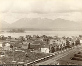
Vancouver, B.C. from Mount Pleasant
Part of Major Matthews collection
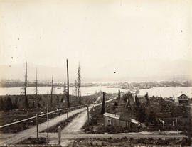
Photograph shows a view from west of Westminster Avenue (Main Street) looking north across False Creek

Mount Sir Donald, C.P.R. Selkirks, Height 10,645 feet
Part of Major Matthews collection

Part of Elizabeth Abbott fonds
Item is a photograph showing a view of Burrard Inlet looking east. Two men and a girl are pictured standing on a boardwalk in front of a church building in the foreground.

Part of Elizabeth Abbott fonds
![[Looking north across Burrard Inlet]](/uploads/r/null/1/0/10595f63eed708de2ed8abb3877eca441f8ce2fb8d740ec893ee302f48d560bf/2136f30a-0a33-4f60-9bf2-e6fa88196989-A61536_142.jpg)
[Looking north across Burrard Inlet]
Part of Major Matthews collection
![[Looking west across False Creek from 7th Avenue and Birch Street]](/uploads/r/null/9/0/909d6883cdf343cfcf7bb2272d35e7f7ffec5dd3152c8417defb4a5234da691b/e1aff9b0-fc57-4004-90f2-0589146b8e29-A43235_142.jpg)
[Looking west across False Creek from 7th Avenue and Birch Street]
Part of Major Matthews collection
Photograph shows a house at 1304 West Seventh Avenue, the Granville Street Bridge, C.P.R. Kitsilano Trestle Bridge and Indian village of Snauq.
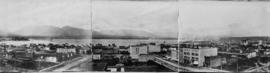
Panoramic view. Image is one of two panoramas mounted on board to show the changes in the cityscape between circa 1890 and 1923.

Vancouver, B.C. from Deck of Incoming Steamer
Part of Major Matthews collection

Part of Major Matthews collection
Panoramic view showing the Kitsilano Trestle Bridge and Yaletown in the background

Upper Bow Valley from cave, Banff
Part of Elizabeth Abbott fonds
![[Panoramic view looking north from the Hotel Vancouver]](/uploads/r/null/d/0/3/d032ae1a08ec1b68763941336f6a07708bf678235ae8cdf506cbbdc3fb10451d/98ea51ff-abce-48a9-9401-16834b8ba6a4-VanScP143_142.jpg)
[Panoramic view looking north from the Hotel Vancouver]
Part of Major Matthews collection
Photographs show the west side of the 600 Block of Howe Street, Manor House, Deadman's Island, the 600 Block of Granville Street, the Van Horne Block, the Hudson Bay Company store, the Homer Street Methodist Church, the tower of Holy Rosary Cathedral and other buildings and houses
![Looking up the Fraser [River] near Yale, B.C.](/uploads/r/null/4/b/4b3f0c2212c0dfc873f6f312a473044ffd8fcd45c157a43f3a07e544ea4ee708/5836a5ef-6581-4515-b342-fb2c42f88316-A26790_142.jpg)
Looking up the Fraser [River] near Yale, B.C.
Part of Major Matthews collection

Medicine Hat and Saskatchewan River
Part of Major Matthews collection
![Mount Pleasant from Westminster Avenue [Main Street]](/uploads/r/null/f/d/fd63732153071da448f488eeeb7356a09daea078b636833e3dca2840c26e6eef/75ec8c28-e1b8-47c5-8888-3ffdb25aa589-A37171_142.jpg)
Mount Pleasant from Westminster Avenue [Main Street]
Part of Major Matthews collection
Photograph shows the Westminster Avenue Trestle Bridge looking south across False Creek
Banff National Park from Cave Hot Springs
Part of Major Matthews collection
![[View of North Vancouver from across Burrard Inlet]](/uploads/r/null/1/8/189ba35cb06084777fb2bda228ad93f3576931c505a2e6b41a11dcde757d3772/4ed44799-0b6d-4458-bc85-5202c7143989-A32577_142.jpg)
[View of North Vancouver from across Burrard Inlet]
Part of Major Matthews collection
Panoramic view
![[View of Steveston]](/uploads/r/null/3/0/302c3997b8191889c52d0eddfeacf50cc858d9c88acb94af07575d8829e8f8a7/d3883ceb-b299-4b9d-a778-2bbb51cdaffe-A33510_142.jpg)
Part of Major Matthews collection

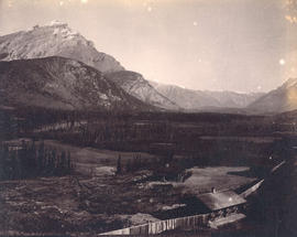
Bow River Valley From Hot Springs, Banff National Park


The Narrows from Stanley Park Road, Vancouver, B.C.
Vancouver, B.C. from the South
Photograph shows a view looking north from the corner of Westminster Avenue (Main Street) and 7th Avenue including the Westminster Avenue Trestle Bridge and False Creek in the background
Victoria, B.C. from Government Buildings
Photograph shows the Sir James Douglas obelisk
![[Looking east across False Creek from 8th Avenue between Alder Street and Spruce Street]](/uploads/r/null/e/c/ec81910bb89081fd2636ff5464fd1457cd8928cea76e4de9b65ee95f9ee914d5/76a61c23-ee03-428b-b662-85ad504a1d1a-A43224_142.jpg)
[Looking east across False Creek from 8th Avenue between Alder Street and Spruce Street]
Part of Major Matthews collection
Panoramic view showing the Cambie Street Bridge
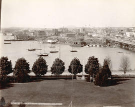
Looking Across the Inlet from Hotel Vancouver
Photograph shows a view looking north across Burrard Inlet from Granville Street and Georgia Street including the Van Horne Block and the Hudson Bay Company Store
Part of Vancouver, B.C. from Hotel Vancouver
Photograph shows the east side of the 600 Block of Granville Street including the New York Block and a liquor store and beyond to the Homer Street Methodist Church, the tower of Holy Rosary Cathedral and houses

Part of Elizabeth Abbott fonds

Vancouver from roof of Hotel Vancouver hotel