
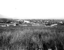
View looking north west from the Jericho Clubhouse
- AM59-F03-: CVA 255-03
- Item
- 1908
Part of Jericho Country Club fonds
10376 results with digital objects Show results with digital objects
View looking north west from the Jericho Clubhouse
Part of Jericho Country Club fonds

Old cart bridge across slough on Jericho Golf Club property
Part of Jericho Country Club fonds

Men approaching fourth green with house of J. MacKenzie Bowell under construction in the distance
Part of Jericho Country Club fonds

A. Kam, club professional, on fourth tee
Part of Jericho Country Club fonds

Left portion of Panorama, view from Point Grey
Part of C.F. Chapman fonds
Item is the left portion of a panorama, which with the following two views was taken looking north from 9th Avenue, about two blocks west of Alma.

Middle portion of Panorama, view from Point Grey
Part of C.F. Chapman fonds
Item is the middle portion of a panorama which was taken looking north from 9th Avenue, about two blocks west of Alma.
Right portion of Panorama, view from Point Grey
Part of C.F. Chapman fonds
Item is the right portion of a panorama which was taken looking north from 9th Avenue, about two blocks west of Alma.
![[Southern view of Samuel and Fitzgerald McCleery's farms - District Lots 315 and 316]](/uploads/r/null/2/9/e/29e5e2ee1ab72e418f96f7141a35b69a66da2b5808f04d8af443c2fdae390ef2/d22eb2ef-a370-4cc4-99f3-9ddec8fddaf8-LP355_142.jpg)
[Southern view of Samuel and Fitzgerald McCleery's farms - District Lots 315 and 316]
Part of Major Matthews collection
Item consists of 3 photographs mounted on board to form a sectional panoramic view of MacDonald Street (Old Kaye Road)
![[The Briggs family on the steps of their house at 25th Avenue and Carnarvon Street]](/uploads/r/null/6/f/6f3949af34bed93b00f55d62ba258fbcc7cff66a115bb17b752999152151b0ab/e6f7072a-773e-4983-ae78-f64d90d7d359-A61071_142.jpg)
[The Briggs family on the steps of their house at 25th Avenue and Carnarvon Street]
Part of Major Matthews collection
Group portrait showing left to right Albert, Clark, Helen, Mrs. Briggs, Wilson Briggs, Mary Briggs. Dr. W.A. Briggs on lower step.
![[View looking North of Fitzgerald McCleery's farm - District Lot 315]](/uploads/r/null/e/f/2/ef2ed8b0811118507913e4d976d8ae641c3fbd921cbe3939fc913f6eee0b42e1/62ba7470-1c4b-4284-bdd8-b755b6364802-LP355_142.jpg)
[View looking North of Fitzgerald McCleery's farm - District Lot 315]
Part of Major Matthews collection
Item consists of 3 photographs mounted on board to form a sectional panoramic view of the roof of the Celtic Cannery
Kitsilano and the Municipality of Point Grey
Part of City of Vancouver Archives technical and cartographic drawing collection
Item is a map showing building lots and block numbers in Kitsilano and the Municipality of Point Grey, from English Bay in the north to Marine Drive in the south and from Granville Street in the east to Blanca in the west.

Lot numbers, boundaries, railway lines and street names in the municipality of Point Grey
Part of City of Vancouver Archives technical and cartographic drawing collection
Primary map shows lot numbers, boundaries, railway lines and street names in the municipality of Point Grey from 16th Avenue in the north to the Fraser River in the south and from Ontario Street in the east to Blanca Drive in the west. A smaller map in the bottom left-hand corner of the item shows the north west portion of Point Grey.
![[Looking west on Buckland Road (West 29th Avenue) from Alma Road (Street)]](/uploads/r/null/0/0/00845954f4d465c43deb4d2e806a6e23524a0dd93df1366dee8518bdfc6da7a4/6293bd29-39c0-4713-951e-7a0ba8a90599-A36986_142.jpg)
[Looking west on Buckland Road (West 29th Avenue) from Alma Road (Street)]
Part of Major Matthews collection
Photograph shows the Convent of the Sacred Heart under construction

Part of Major Matthews collection
Panoramic view showing the Eburne-New Westminster electric railway tracks, a farm, railway cars and Richmond Island in the background.

Point Grey Municipality: Shaughnessy Heights from Granville Street, 1911
Part of Major Matthews collection
Panoramic view showing houses under construction including "Hycroft" and Angus Drive leading to the Crescent.
![[View of Kerrisdale at 41st Avenue and West Boulevard]](/uploads/r/null/2/f/2fdc28ede65ca722a1389a38a078b705eb24f34aba8a4a36b5c43136ab5bd578/a3d147bf-4ade-4da2-ad6e-fc8b1582df83-A42707_142.jpg)
[View of Kerrisdale at 41st Avenue and West Boulevard]
Part of Major Matthews collection
Panoramic view showing the Post Office, a B.C. Electric Railway car, C.P.R. gardens and stables.
![[View of Shaughnessy Heights from Matthews and Wolfe Avenues]](/uploads/r/null/7/a/7acb3ce988104aa35f7cc0ef699ee3d6d77b31db327eb17199464b5026aae1be/e55c7857-14f4-46f5-83d4-b455704426e4-A65563_142.jpg)
[View of Shaughnessy Heights from Matthews and Wolfe Avenues]
Part of Major Matthews collection
Panoramic view showing King Edward High school and Vancouver General Hospital.
![[Baptist Church choir]](/uploads/r/null/e/8/e8b9891fc00e4141729e91fe0025218538fd28e775d50acf9fd10e6417106583/c855c17c-e608-4773-b6ed-9fb1a8c27680-A50547_142.jpg)
Part of John Davidson fonds
Group portrait

Point Grey Municipality Junction of Marine Drive and South Boulevard 1911
Part of Major Matthews collection
Panoramic view showing four men in an automobile
![[View towards Point Grey Municipality showing] Water Frontage Eburne Townsite North Arm of Fraser...](/uploads/r/null/1/d/1d8774dd9107ded6d04bac9dc60db01a87242aaddefd3862cd637f3ee5811fba/b3e8b32c-ad04-4213-8df9-ba2911929967-A63097_142.jpg)
Part of Major Matthews collection
Panoramic view

Point Grey Municipality, View of Kerrisdale (Municipal Hall on Left) 1911.
Part of Major Matthews collection
Panoramic view showing Wilson Road (41st Ave), Blair and Perrin Real Estate Office, the Post Office and the B.C.E. Railway freight shed and passenger shelter.
![[Southward view of McCleery Farm]](/uploads/r/null/c/8/c8a6e893d77b6572d53b6cd1f468628d2418459bef04b42b975bb9088adab3d3/31e21f4c-8bc5-4e23-b916-0ceee22c16b1-A65559_142.jpg)
[Southward view of McCleery Farm]
Part of Major Matthews collection
Panoramic view showing old Kaye Road (MacDonald Street)
![[Jericho Country Club]](/uploads/r/null/b/8/6/b86d716b23dc5bf5a6b72c3fe01813de3627aa3d9c2c8c1647ae16fd6e7c13f2/5c910c23-4a9c-48f6-adfd-1bb472379668-VLP170_142.jpg)
Part of Major Matthews collection
Item is a photograph mounted on a large cardboard support. A typed caption was adhered to the board below the photograph by Major Matthews, and reads "As the old Jericho Country Club departs, and the Royal Canadian Air Force enters, this picture was removed to City Archives 14 September 1942."
![[View of Burrard Inlet from Point Grey]](/uploads/r/null/e/3/e320d8072b352225b343a6bf036a24dfbe3d1f2d722001dd0b12d0aa899d36bb/bb12fe87-3475-4839-9e59-891393008d05-A64782_142.jpg)
[View of Burrard Inlet from Point Grey]
Part of Major Matthews collection
Panoramic view showing a pier and Stanley Park in background.
![M.P. Cotton Co. Ltd. [gravel bunkers] Shaughnessy Heights [Matthews Avenue and Granville Street] ...](/uploads/r/null/a/3/a3c3e49283213eaf8813be731cd03d90049f20d1090b8128156bdef544b04e12/ca813fc0-66c8-4ad6-bc8d-afb974d1431a-A24665_142.jpg)
Part of Major Matthews collection
Men in foreground identified (left to right): John Neave (with dog), unidentified, Mr. Mulhern, Bill Johnson, Charlie Cockering.
![[View of Burrard Inlet toward Howe Sound from Point Grey]](/uploads/r/null/d/7/d70841724af53c279a31c140bbc1fce42a0aa6a1d3a9c40cff087f263ccc345d/7095bde6-1c57-4e91-b87a-60bb6b7cd9f3-A64735_142.jpg)
[View of Burrard Inlet toward Howe Sound from Point Grey]
Part of Major Matthews collection
![[1912 American-La France Hose Chemical wagon and firefighters in front of Point Grey Firehall No. 1]](/uploads/r/null/5/9/0/590a2f772f6506d4206377625b9c2c493282a86428ee8591c5a88e52f5c593d8/0222654e-7112-41a6-8475-f12b5d48c0b4-CVA354-034_142.jpg)
[1912 American-La France Hose Chemical wagon and firefighters in front of Point Grey Firehall No. 1]
Part of City of Vancouver fonds
[The men living in Robert McLean and Company construction camp on Macdonald Street at 50th Avenue]
Part of Major Matthews collection
Item is a photograph. Notes written on the back: "I think this is site of Forrest Rogers palatial home"
![[Laying trunk sewer from Kerrisdale to the Fraser River]](/uploads/r/null/9/f/9f5691f4bb949c2c43aa49431a3146c75c8df384be7cc8beace29b352a07ac09/19ed0619-4d80-4af9-83e9-4cf8586636b4-A61285_142.jpg)
[Laying trunk sewer from Kerrisdale to the Fraser River]
Part of Major Matthews collection
![The Royal Nurseries [at 49th Avenue and the Royal Station of B.C. Electric Railway]](/uploads/r/null/b/7/b7a9db8c7ff73fb70f8d5de5f6878301d3dc9b5828079da405d03b42dfad0565/057d5d90-a08a-4f3f-9e20-0985a3bf8803-A18093_142.jpg)
The Royal Nurseries [at 49th Avenue and the Royal Station of B.C. Electric Railway]
Part of Major Matthews collection
![[45th Avenue looking east from Larch Street showing sewer construction]](/uploads/r/null/3/5/3540b5b388cf3467586ec3c06948f62b177f3d47be362b2a3aae18f57dfd6064/de9b1987-d8f6-47dc-bc5d-d14526d5ccd9-A61287_142.jpg)
[45th Avenue looking east from Larch Street showing sewer construction]
Part of Major Matthews collection
![[The men living in Robert McLean and Company construction camp on Macdonald Street at 50th Avenue]](/uploads/r/null/c/b/cba484b7ddc9f75bc56aa33f8a204d94e981e5b5fb40399381dcf5b62dc8325d/d810b4fd-1dad-43fe-ad7f-619f02a60c37-A37118_142.jpg)
[The men living in Robert McLean and Company construction camp on Macdonald Street at 50th Avenue]
Part of Major Matthews collection
Group portrait
![[The trunk sewer from Kerrisdale entering the Fraser River]](/uploads/r/null/6/b/6be17f1644555d87814c69573b7019504e87069d8583e971fae7de32092fb96a/c1cba521-c224-4741-99d9-ed751379d7c7-A61286_142.jpg)
[The trunk sewer from Kerrisdale entering the Fraser River]
Part of Major Matthews collection
![Marshall Plummer Contactors Macadamizing King Edward Avenue [25th Avenue] and Heather Street](/uploads/r/null/6/a/6a7c007047e3acc872457437536e53562f3a92d56f883d73ef50f1093b793de1/78cfea6b-cde2-486e-8d0d-53941ec4ef63-A37138_142.jpg)
Marshall Plummer Contactors Macadamizing King Edward Avenue [25th Avenue] and Heather Street
Part of Major Matthews collection
Photograph shows a steamroller
![[Northern view of the clearing of the Second Shaughnessy Heights for subdivision]](/uploads/r/null/7/8/78d8a0d2496efc7cc65dc7aa0ffc312aa8b08132be47a6b0334d00ee9b7f5d01/1d358ea8-bd9b-4d8a-8f5d-ebd80b257775-A66610_142.jpg)
[Northern view of the clearing of the Second Shaughnessy Heights for subdivision]
Part of Major Matthews collection
Panorama view showing the area between 33rd Avenue and King Edward Avenue and west of Granville Street and east of Oak Street, construction workers and in the background the construction camp, Shaughnessy School, Braemar School and Little Mountain
![[Looking east from Elm Street along Wilson Road (41st Avenue) at sewer construction]](/uploads/r/null/4/0/40deab96e9876882a4d107ec6388f6e0a278f08ff9456d2061d298cef7ca5e2e/8c6b7acf-6e75-491a-aac8-15b0cd0ba47f-A61282_142.jpg)
[Looking east from Elm Street along Wilson Road (41st Avenue) at sewer construction]
Part of Major Matthews collection
Photograph shows D.W. Johnston, W.B. Grier and others inspecting the pipe
![[Sewer construction on Balsam Street between Wilson Road (41st Avenue) and 43rd Avenue]](/uploads/r/null/c/7/c74ae55486e09a12925420883018ca42e279126e8d1b632697938151ae39ccc9/57c59201-e33b-44e8-b36c-b74b4dff24bc-A61288_142.jpg)
[Sewer construction on Balsam Street between Wilson Road (41st Avenue) and 43rd Avenue]
Part of Major Matthews collection
![[Laying trunk sewer from Kerrisdale to the Fraser River]](/uploads/r/null/c/6/c6c44b65244feb8a6b58facc011b82505eb239abe19dc3c18fa2adb90bece584/45c8bb26-25d5-4a3e-9134-9d97d6408245-A61283_142.jpg)
[Laying trunk sewer from Kerrisdale to the Fraser River]
Part of Major Matthews collection
![[A man in the sewer trench on Wilson Road (41st Avenue) near Larch Street]](/uploads/r/null/b/0/b0779ab46661963967019998ef0740f514787d6ef9fd37a610ca958870cc1f12/572311b3-18ab-4d53-aafe-24b8f45d5a4a-A61284_142.jpg)
[A man in the sewer trench on Wilson Road (41st Avenue) near Larch Street]
Part of Major Matthews collection
[View of house, barn and silo in Kerrisdale]
![Kaye Road planking [by] Marshall Plummer and Company Contractors](/uploads/r/null/3/a/3ad24d7a82ca1193a1184063e1ecfa55901f9948cffb2984c5de2ac940035ffd/041db5af-4259-4b8d-b2e1-d3639c82b488-A37142_142.jpg)
Kaye Road planking [by] Marshall Plummer and Company Contractors
Part of Major Matthews collection
Photograph shows Trafalgar Street looking south from 18th Avenue
![[Exterior of M.P. Cotton's residence - Matthews Avenue and Granville Street]](/uploads/r/null/8/2/82acdbebab59c8e384ce6734abcebe6b18120d067e462b03b5c7aa0400f0e9bb/3ee21432-e662-4e1c-a739-8d3b000fe644-A24668_142.jpg)
[Exterior of M.P. Cotton's residence - Matthews Avenue and Granville Street]
Part of Major Matthews collection

R. McLean Company - Point Grey Reservoir Vancouver, B.C.
Part of Major Matthews collection
![Sterling Road [Balaclava Street] Clearing](/uploads/r/null/6/3/63d250613f6a400f3aefc56141bfe3335bb555c3e3e6fc9abc670eb1103ce73a/75aadcff-e760-4da1-8408-1cf08411b2ab-A25933_142.jpg)
Sterling Road [Balaclava Street] Clearing
Part of Major Matthews collection
![[Mr. Mark Mount and Mr. McRae felling trees at 3379 West 22nd Avenue]](/uploads/r/null/f/d/fd5ce0f34e09a4e3c969c6465f06fdc7940190913db0503143855fd7ca00f31d/c9b95948-d069-4bb6-ac35-9e438a5593ad-A68664_142.jpg)
[Mr. Mark Mount and Mr. McRae felling trees at 3379 West 22nd Avenue]
![[Rotary Club luncheon in the Royal Nurseries and Floral Co. Ltd. greenhouse]](/uploads/r/null/9/7/979112c68df81dd935ff81ffaf81c7a013328d0be6ea503fad8435fdf9860e02/f329cfa3-7a0e-4d16-b7c7-2faa7f1e1766-A25129_142.jpg)
[Rotary Club luncheon in the Royal Nurseries and Floral Co. Ltd. greenhouse]
Part of Major Matthews collection
![[View across the Point Grey Municipal Hall grounds towards the rear of the Bowser Block]](/uploads/r/null/5/3/530d1e68c9b45ab1c6bfdb9893ffb9b0b664fc52cba3c1b420b290a29dc797f5/a1d3a91c-6fde-485e-a70c-321804ba547b-A50236_142.jpg)
[View across the Point Grey Municipal Hall grounds towards the rear of the Bowser Block]
Part of John Davidson fonds
![[View across the Point Grey Municipal Hall grounds towards West Boulevard]](/uploads/r/null/7/e/7e5090214bf42d9affc1e583cf9aae3b80f35916897a7631c4b2395e3f46bae0/6fc975be-3b6f-4987-83da-3bc8b0fa4405-A50237_142.jpg)
[View across the Point Grey Municipal Hall grounds towards West Boulevard]
Part of John Davidson fonds
![[A road under construction in Kerrisdale]](/uploads/r/null/8/a/8a7d75a13812294737e3bd50eb291124c9b2332cbf013bebca75a43937245940/b0648573-092b-4ae3-afdd-61b174bd2e8a-A50238_142.jpg)
[A road under construction in Kerrisdale]
Part of John Davidson fonds
![[Cleared land]](/uploads/r/null/d/e/de139dd596e4126aa39ba3d2f12bbe582e8ebb49d2b43eaf9fd22d98fdcedef9/58ed49c7-5ea7-417a-a660-a13a5753ed3f-A50442_142.jpg)
Part of John Davidson fonds