
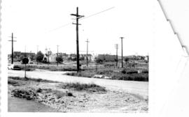
Looking south-west from Raymur Avenue
- COV-S305---: CVA 181-34
- Item
- May 28, 1964
Part of City of Vancouver fonds
1404 results with digital objects Show results with digital objects
Looking south-west from Raymur Avenue
Part of City of Vancouver fonds

Area A-1, Relocation of Raymur Avenue
Part of City of Vancouver fonds

Part of City of Vancouver fonds
![Area A-2 [Looking north-west. from 1000 Block Union Street]](/uploads/r/null/1/8/c/18c52e9c6ad49618ad4970e1d4e3577ab59b064154b43a899ad4a2e76673fbc7/741daa67-a4fa-4c43-9c8d-f215ae9de615-CVA181-32_142.jpg)
Area A-2 [Looking north-west. from 1000 Block Union Street]
Part of City of Vancouver fonds
![New McLean Park housing [including Seniors' high-rise] taken from Jackson and Keefer](/uploads/r/null/b/f/a/bfac2eabe8a447d0aee24683f533e461cdeaa18f98d1ce543f39a2f4b30e7b0d/c4c46066-4e6f-4d23-a81c-792f19f6850e-CVA181-18_142.jpg)
New McLean Park housing [including Seniors' high-rise] taken from Jackson and Keefer
Part of City of Vancouver fonds

View of high-rise housing in McLean Park from Dunlevy and Keefer
Part of City of Vancouver fonds

View of high-rise housing in McLean Park from Dunlevy and Keefer
Part of City of Vancouver fonds

View of Keefer street and corner of high-rise housing in McLean Park, from Dunlevy and Keefer
Part of City of Vancouver fonds

McLean Park housing at Dunlevy and Union Streets
Part of City of Vancouver fonds

Plan of subdivision of block 120 (explanatory plan 8011), district lot 181
Part of City of Vancouver fonds
Item is a map annotated to show locations of hydro, telephone, water and gas services and sewers on the east side of the area cleared for development between Campbell Avenue, Raymur Avenue, Hastings Street, and Union Street. Base map is a subdivision plan for the area.

Manke's Cabins from Hastings Viaduct (900 Block E. Pender Street)
Part of City of Vancouver fonds
Russian Church at Georgia and Campbell
Part of City of Vancouver fonds
Projects no. 1 and 2 maps and plans
Part of City of Vancouver fonds
File consists primarily of maps pertaining to redevelopment project 1, areas A and D, but also contains two maps from project 2. Maps include identification plans of property to be acquired; boundaries of clearance areas; general and detailed redevelopment plans; and maps showing the layout of existing and proposed utilities.

City of Vancouver redevelopment : project 2, area A-2
Part of City of Vancouver fonds
Item is a map annotated with numbers, letters, and outlines on some properties in the Strathcona area. The significance of the annotations is unclear. Base map shows streets and legal addresses from Main Street to Clark Drive and the waterfront to Atlantic Street.

Part of City of Vancouver fonds
Item is a photograph showing the demolition of 971-977 Keefer Street. Annotation on back: "Clearing for relocation of Raymur Ave and site for Raymur housing."
Part of City of Vancouver fonds
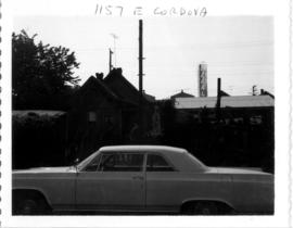
Item is photograph showing a house at 1157 E. Cordova Street with a car parked out front.

Part of City of Vancouver fonds
Item is photograph showing a house at 1157 E. Cordova Street.

Part of City of Vancouver fonds
Part of City of Vancouver fonds
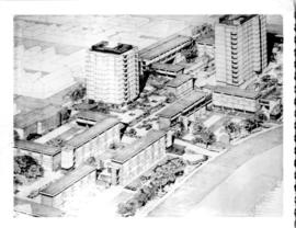
Item is a photograph showing a model of the Raymur Housing project.

Plan of subdivision of block 120 (explanatory plan 8011), district lot 181
Part of City of Vancouver fonds
Item is a map annotated to show areas (in square feet and acres) of lots on the east side of the area cleared for development between Campbell Avenue, Raymur Avenue, Hastings Street, and Union Street. Base map is a subdivision plan for the area.

Sign on Union Street indicating Federal and Provincial and City support of Raymur Housing
Part of City of Vancouver fonds

Part of area "a" : plan of redevelopment, Strathcona
Part of City of Vancouver fonds
Item is a map showing the boundaries of project 1, project 2 and scheme 3, the proposed land use, the propsed ultimate street system, the new streets and lanes in projects 1 and 2, the easements in projects 1 and 2, the sites in project 2 not to be acquired, the buildings in projects 1 and 2 to be retained and the area a-6 (north) in the area from Railway Street in the north to Atlantic Street in the south and from Clark Drive in the east to Main Street in the west.
![The west end of Block 86 [Keefer Street - south side]](/uploads/r/null/7/1/8/718449a61ef28d000997ee1b4ee269fef37aabc4b15790ac496d415a6878035c/1751ccf4-5686-4608-93fb-1a3262368ccb-CVA181-22_142.jpg)
The west end of Block 86 [Keefer Street - south side]
Part of City of Vancouver fonds
Item is a photograph showing the west end of Block 86 (south side of Keefer Street). Stamp on back of photo: "Received by Property and Insurance Office, April 28, 1966".

Part of City of Vancouver fonds
Item is a map created to depict utilities in the proposed project 2 area 6. The map shows fire alarms, sewer lines, water lines, gas lines, underground telephone lines, underground power lines, underground vaults, and curbs. Also noted are existing buildings which may be cleared in future projects, existing buildings in immediate vicinity of area a-6 which may remain, existing subdivisions to be cancelled, easement boundaries, approximate elevations at street intersections, approximate locations at contours and areas for disposal ("private development" and "public housing").

Strathcona rehabilitation program
Part of City of Vancouver fonds
Item is a map showing streets and building outlines in the area bounded by Main Street, Glen Drive, Hastings Street, and Malkin Avenue.
Part of City of Vancouver fonds
File consists of identification plans and redevelopment plans for project 2.
![[209 Union Street - Vie's Chicken and Steak Shop, 2 of 2]](/uploads/r/null/9/3/2/9329438b2eba511ee68f0bdbafd43891976f3d8edc969207685f36bb42d72f46/01c3e39d-fa8d-4d78-bf09-2df5930ea955-CVA1095-14386_142.jpg)
[209 Union Street - Vie's Chicken and Steak Shop, 2 of 2]
Part of City of Vancouver fonds
![[207 Union Street - Wally's Shoe Shop]](/uploads/r/null/e/b/3/eb3fa7bf24e1b5c182cb06695b374ed63fc9d8209a4b3b145fdb7cfd6a7d6b38/e5b57107-a00c-4a3d-89fd-e282dffd66cf-CVA1095-14384_142.jpg)
[207 Union Street - Wally's Shoe Shop]
Part of City of Vancouver fonds
![[209 Union Street - Vie's Chicken and Steak Shop, 1 of 2]](/uploads/r/null/0/7/6/0767981674b17c04c5276a026aa2906e9a6ce45afc329e6e5f0e664dddacb455/04697d40-292f-44dc-a29e-a3311c780371-CVA1095-14385_142.jpg)
[209 Union Street - Vie's Chicken and Steak Shop, 1 of 2]
Part of City of Vancouver fonds
![[823 Clark Drive - Hammond Furniture]](/uploads/r/null/e/d/9/ed994c7c08671d669d7c1c26ef22bc78e129e6eb23f28008f1b354f339bd2992/b8377d93-f3d6-45b8-8c74-ea7147ab6c4f-CVA1095-14215_142.jpg)
[823 Clark Drive - Hammond Furniture]
Part of City of Vancouver fonds
![[255A East Georgia Street - New Sunrise Rooms]](/uploads/r/null/c/b/8/cb8782125f8dcc8fcefedd69456cbeb321017a867b042081b86dfc3e106ddbc5/d4b2b148-b384-4485-b2b4-b9076a6561af-CVA1095-11594_142.jpg)
[255A East Georgia Street - New Sunrise Rooms]
Part of City of Vancouver fonds
![[243 East Georgia Street - Wallace Block building]](/uploads/r/null/a/1/5/a1529b592a4608250e1d0a1f35d3aef439f0a60ef9def930e0b73192595a2c2f/a8ef675d-c38d-41ef-a96f-6758ee6119e4-CVA1095-11597_142.jpg)
[243 East Georgia Street - Wallace Block building]
Part of City of Vancouver fonds
![[207-215 East Georgia Street - Georgia Rooms and Linford Saddlery]](/uploads/r/null/0/2/b/02ba8546c17c8a3c5ae7960e5621653d8321169e767ad950605bebad3efa4607/10d05cb4-fb7c-4bfe-b9b3-c14258d3aeec-CVA1095-11601_142.jpg)
[207-215 East Georgia Street - Georgia Rooms and Linford Saddlery]
Part of City of Vancouver fonds
![[200 block Union Street houses and buildings, 3 of 3]](/uploads/r/null/5/b/b/5bb5908f7601f0adc90306544e01555c15923346382903d8374d7607efdfe81b/2959fc45-2adf-4940-81ef-eadb4d4ab9fb-CVA1095-14332_142.jpg)
[200 block Union Street houses and buildings, 3 of 3]
Part of City of Vancouver fonds
![[Union Street houses]](/uploads/r/null/e/a/d/eadd0630f8fc2d1cd725d45b76fc496bf61588eed4178a34a2f16bfe7942bcd6/5bbe6f35-e1a8-4833-8d37-64845a616c34-CVA1095-14336_142.jpg)
Part of City of Vancouver fonds
![[265 Union Street, 1 of 3]](/uploads/r/null/f/9/8/f984efc595405755474453e6118338920f7c62471914448733d8d0b6451f2c16/66ebacd2-549c-456a-8d6a-78c1a773eaef-CVA1095-14340_142.jpg)
Part of City of Vancouver fonds
![[200 block Union Street bungalow]](/uploads/r/null/e/4/f/e4f5a7cdc92fbff6ef994992b2c73334720048b107191661a825bade0c7d47da/3220ef4f-36a2-451f-8086-92cb73ec92e3-CVA1095-14334_142.jpg)
[200 block Union Street bungalow]
Part of City of Vancouver fonds
![[296 East Georgia Street - Shell Gas Station]](/uploads/r/null/c/7/7/c770b3ce1068158f1ce017d57ca6c45ef947a3ce04612ab7d5f385ec2dbdef7b/986e3eaa-de8a-41ea-811c-9cf8e48a1b1e-CVA1095-11585_142.jpg)
[296 East Georgia Street - Shell Gas Station]
Part of City of Vancouver fonds
![[259 East Georgia Street - Ho Sun Hing Printers]](/uploads/r/null/8/2/7/82713f71ec1f22e3681ea38361bfe9ad110a777cdfc97d95b7156a387dda80c6/e854d2e6-8f81-4a6f-89e2-a42b2f1a9266-CVA1095-11593_142.jpg)
[259 East Georgia Street - Ho Sun Hing Printers]
Part of City of Vancouver fonds
![[227 East Georgia Street - Keefer Laundry and Dry Cleaning]](/uploads/r/null/8/a/7/8a74c9c85b44a7fa1ded86bdf95548183aae60f8e8f84660ca6d0809cba4990e/9466c868-5787-4d51-a5f9-cc676e0a2525-CVA1095-11598_142.jpg)
[227 East Georgia Street - Keefer Laundry and Dry Cleaning]
Part of City of Vancouver fonds

Part of City of Vancouver fonds
![[200 block Union Street building]](/uploads/r/null/2/c/2/2c29f3ad4b9320868dde6c7acae2d46ceed2a1fb9336b2f097ea50957c82ac09/eece6879-149f-44ac-88e3-3cc1193087ad-CVA1095-14323_142.jpg)
[200 block Union Street building]
Part of City of Vancouver fonds
![[241 Union Street - Sarah's Café]](/uploads/r/null/0/4/e/04e0b711bb092462df575687b5252a9a7fad76250a4a4e9295fa79e5e86d7521/73833d64-641e-487f-b436-6c2694c0bd90-CVA1095-14324_142.jpg)
[241 Union Street - Sarah's Café]
Part of City of Vancouver fonds
![[245-249 Union Street - Gerrard Company Ltd. Strapping Systems and Chow Produce Ltd.]](/uploads/r/null/a/f/1/af1d2da524b759bf0e5dc693b1bd0bbe71700833715f4a388e67b449441aac71/f00fc762-d81e-484e-a430-37f4c968a4e4-CVA1095-14326_142.jpg)
[245-249 Union Street - Gerrard Company Ltd. Strapping Systems and Chow Produce Ltd.]
Part of City of Vancouver fonds
![[249 Union Street - Chow Produce Ltd.]](/uploads/r/null/f/e/e/fee97e22ccad971ee53df09a407cd2668a60f1cb5c9d71d225ea13b2892190d7/8db6ecd7-c9d9-47d7-9288-cc5dbc36c07c-CVA1095-14327_142.jpg)
[249 Union Street - Chow Produce Ltd.]
Part of City of Vancouver fonds
![[200 block Union Street house]](/uploads/r/null/a/7/2/a72998c187b9e8b17a562dced5ae68c6fd931f862d4af1c0bbfb1a91ab7c0401/f61cb112-2383-4052-8f9c-3921700ae391-CVA1095-14329_142.jpg)
[200 block Union Street house]
Part of City of Vancouver fonds
![[200 block Union Street houses and buildings, 1 of 3]](/uploads/r/null/c/7/d/c7d316211cb4f143581ef7628d03418057afbef2e8ba7648872ccac94bfb9027/d576fde2-9d2e-47b6-9cf2-d00a3e166f5b-CVA1095-14330_142.jpg)
[200 block Union Street houses and buildings, 1 of 3]
Part of City of Vancouver fonds
![[271 Union Street]](/uploads/r/null/6/3/c/63c8e72ce037941b1c629896970a0a8d54d102e40daf8c9449568780a7613add/1736c7fc-0cd5-4fdb-9d48-f0281c54ec06-CVA1095-14333_142.jpg)
Part of City of Vancouver fonds
![[200 block Union Street house]](/uploads/r/null/c/5/0/c50e4e57921ee35801c042712db5084ce4354bd4e87d202ddaac244c9f30e45c/29a8a30b-98c7-4807-a3a8-638a96dd9a68-CVA1095-14335_142.jpg)
[200 block Union Street house]
Part of City of Vancouver fonds
![[263 Union Street]](/uploads/r/null/f/9/e/f9e45c6844e234e9dcd0559d87f498d0f24932e9331ed800d8632f5daf3c7ff4/d91867aa-95e0-4e97-a673-149feeeabf6b-CVA1095-14339_142.jpg)
Part of City of Vancouver fonds