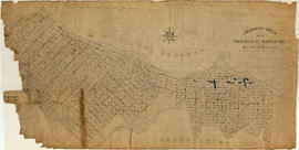
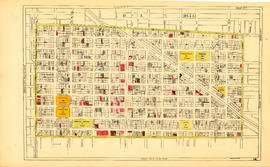
Item is a section showing Maple Street to Richards Street and Drake Street to Third Avenue. Includes streets, roads, blocks, lots, legal descriptions, parks, schools, the Burrard and Granville Street Bridges, C.P.R. right-of-ways, the Squamish Band reserve, C.P.R. leases and property, and government reserve. Map includes Granville Island. Map is hand coloured to show tax sale property for sale, property with no water, street widening and drainage, replotting, reserved land for schools, reserved land for parks, sundry land, capital assets not including schools and parks, schools, and parks.
Vancouver (B.C.). Office of the City Engineer
![[View of fire at G.H. Cottrell Warehouse, 139 Water Street]](/uploads/r/null/d/4/2/d42e9cc6d0ed113b820738761abee8e002b3343ece277b2d2aa63d56af341039/38d982ad-3791-47df-aa20-a24e3dff0244-CVA354-018_142.jpg)

![[Looking west towards the southwest corner of the 2400 Block Kingsway at Broadway]](/uploads/r/null/a/e/aef43aff9ffe4f4e13146bc92fe519874797f4e7103237fe9bbacdbb5286405a/c5714b94-93cd-49b0-8d4d-6b73282b3f69-A16548_142.jpg)
![[100 block Pender St.]](/uploads/r/null/a/7/a74d7295b32f5a3ff72238c96104b6fbc9389340b17b19a79228a52601a36e4d/dd7ccf36-0ac7-4e5c-b777-a705563d3718-A16540_142.jpg)
![[People on street in front of Union Bank of Canada at Hastings and Main]](/uploads/r/null/4/7/47369ef87561a6883a1f5567410f57e1f8187bf212a98074c258d72e8d662262/b2d10f16-3526-4e34-82c6-90a116eaeaa3-A16546_142.jpg)
![[300 block Main St. E.]](/uploads/r/null/1/7/17e0ea9626d39ff165dea1631a9db1b37cb1b4837b31f35ef1fff0f3a74859be/e2eb0862-86a4-470f-97e0-29d92848efb7-A16551_142.jpg)
![[Coal Harbour view from Denman Street]](/uploads/r/null/f/4/f4ee6b5b8d147b8a774a97a7b59f6f8c29bb8792a52da1695f47dce307742555/f90773a4-4b21-478d-bd42-505e1d441b47-A16624_142.jpg)
![[1908 Amoskeag self-propelled steamer with firefighters on street at No. 1 Firehall]](/uploads/r/null/1/3/5/13521aa9822ab0621dd174314ab0da79b3c9464050100ca355b44e2981514ca5/c293057e-0626-45c0-900a-16d6af894027-CVA354-038_142.jpg)
![[800 block Granville Street]](/uploads/r/null/a/2/a27dd96544a4938fdbc93769293bb5e9dea3d7527648dc8f8618f9c412f5c0e5/3db99d00-a437-469b-81f4-18b5d692b7dc-A16544_142.jpg)


![[Firefighters atop aerial ladder in No. 2 Firehall truck on Seymour Street]](/uploads/r/null/e/b/e/ebed39d1a2b9ea2207235d6682e197186c16c1a61362cc398c6b092fea30c2c5/e6eb149a-118a-4ce7-a6e9-1f0c83811b98-CVA354-387_142.jpg)
![Hastings & Richards [after heavy snowfall]](/uploads/r/null/8/d/8dae8c86194b776f791816e7178f37f25d2ca092e4ce33c876d4ef943ca11390/2f54af95-f447-4ee4-baa2-fae5caf4d300-A16576_142.jpg)
![Main & Pender [after heavy snowfall]](/uploads/r/null/2/0/20a96dda955a3b32ec32c0bee2433de6bc2e4362d4f024c6c86d5a24d886e1b9/fe059248-51f2-4ade-bd52-226b271e9eb8-A16579_142.jpg)
![Davie & Granville [after heavy snowfall]](/uploads/r/null/9/5/957a5cb72e66af500c4a5348592f923ed6d5231c93ae0eb0929df0f007d44f61/6a9458e8-2283-4d5d-b455-8aa0e5367350-A16575_142.jpg)
![[Hastings and Richards after heavy snowfall]](/uploads/r/null/e/9/e9d02bd659129635b1478a4fc6e9bf0c9cd8498067eba2c1fb866a9d52e3db0d/8d97b4f0-d8ea-43e9-a1e1-bbdd77d4f1ba-A16577_142.jpg)
![[600 block Hastings St. W. after heavy snowfall]](/uploads/r/null/1/e/1e87b92ddb583d44c61d56889b5e305648cf593c9a1dd564c5f68991f9d48398/5fc1063f-3fc6-43ed-835d-539dd82a3927-A16578_142.jpg)


![EL [electrical? ]Pole, Abbot and Pender](/uploads/r/null/0/8/0846e1ecd813e8c1a09247f0875209d538c950a2a4bf4331a5b58d2be88926d0/774ce90f-22d5-4563-b8ed-c7ca1480a9ac-A16541_142.jpg)


![[200 block Kingsway]](/uploads/r/null/7/7/77394b8f6743426401ba89776a603af6113100f7e0353fc7d5472c96400bd87d/f14b09f3-f973-445e-a163-a97329a90eea-A16549_142.jpg)
![[Homer Street looking south from Pender Street]](/uploads/r/null/4/f/4fb1eb21c79aea2a6882eded5276e1b712addc994860fed837c4ca83ba90ec29/1eb98cad-709e-4b39-b7d9-283aee1c6aed-A16542_142.jpg)
![[Deputy Chief C.W. Thompson at wheel of automobile in front of house, location unknown]](/uploads/r/null/0/7/9/079e0aa56e8021afe42cffa066588b8247abfa2d6241e7fa304e3bba3787c957/9464de60-42fe-4f1c-a30c-109c825dc061-CVA354-054_142.jpg)


![Cambie and 12th [Avenue] taken looking south west from the City Hall](/uploads/r/null/a/9/a95f8048b04d26c3060361b361c2b136bb58d850bbddd32cf9f2dc465086b275/92b1e557-98de-4bde-b1e7-944c3db510dd-A43707_142.jpg)
![[Photograph of a stoplight]](/uploads/r/null/0/0/00e46d8380a39fb16ca7911ba995eb3d714b9477dab76e3de5807f7d1eddc65f/62994856-7cd6-450e-bbb5-5a8a896ad3b0-A43702_142.jpg)
![[Photograph of a stoplight]](/uploads/r/null/7/4/74c224b383e1f94c182abad984ae1f2bf4ddfb3986b553762fdb976feabed022/fe00f732-37f2-4e7c-a3c1-f1ee5b245c8b-A43703_142.jpg)
![[Pender Street at Cambie Street, looking west]](/uploads/r/null/3/a/3a80c7b7e509c525c418bc41054ed92df1e0be5c3bef2d0f287cfd8db9c5fe96/332b8a52-20f2-4e06-b921-96385a7fc67c-A43704_142.jpg)
![[Pender Street at Cambie Street, looking west]](/uploads/r/null/2/7/2774aa5bbd600e7ecc8ddebbfd0e6d705930e4d81e1bb42dde273283274b8e07/534d7f11-7691-413e-872e-4c1a9d3ee9d8-A43706_142.jpg)
![[Pender Street at Cambie Street, looking west]](/uploads/r/null/3/d/3d91c3d4cd2181022a308d60e8fad6da587efcfa17cc0a68527eb95c215bc009/5a8ff240-1741-4881-b137-7b3a66b98a1d-A43705_142.jpg)


