
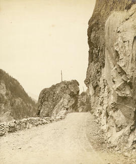
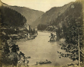
Great Bluff on the Thompson River
- AM1376-: CVA 3-39
- Item
- [between 1866 and 1870]
Photograph shows donkey-drawn covered wagons at 8 Mile Bluff
173 results with digital objects Show results with digital objects
Great Bluff on the Thompson River
Photograph shows donkey-drawn covered wagons at 8 Mile Bluff
![Lady Franklin Rock [in the Fraser River near Yale]](/uploads/r/null/f/a/fabad1c5fa1579282fecdc233200df38964019ea6c3956cc3d3be46cdc4209ca/47c8994c-4ee6-47c4-b9c5-b06ac1e91fa4-A19671_142.jpg)
Lady Franklin Rock [in the Fraser River near Yale]

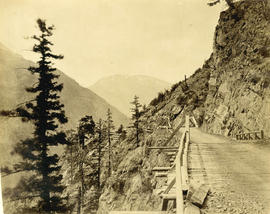
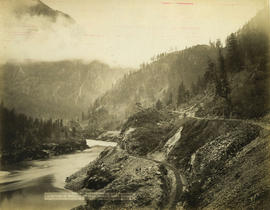
Nicaragua Bluff and wagon road from west side of Fraser River
![Thompson River from Nicomen [Mountain] looking down 67 miles above Yale](/uploads/r/null/b/4/b4a259f5128b861d7e65e59d707e7e332111f4e3b39837b523d2d908d9362f5f/49bab35b-e81d-46d9-865e-3fc0376674ba-A19696_142.jpg)
Thompson River from Nicomen [Mountain] looking down 67 miles above Yale
Wagon road over Jackass Mountain
Descent from the summit of road over Jackass Mountain
Photograph shows donkey-drawn covered wagons
![Wagon Road looking down [Fraser River]](/uploads/r/null/d/3/d31f33f3f68e921c25dc34269c92a6bbaa05550c337ff84c66b4e5640adc5d0d/6dbaba4f-967d-4271-857e-3299e25f0212-A19680_142.jpg)
Wagon Road looking down [Fraser River]
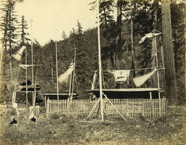
Indian cemetery near Boston Bar
Indian cemetery near Lytton on the Thompson River below Spences Bridge
Photograph shows a grave with funeral artifacts
![Lady Franklin Rock [in the Fraser River near Yale]](/uploads/r/null/3/0/30e4a67b983698de8acc03740dd17a80e4f7a567b29da2ea51be9ea5c379c930/ee5161f4-0613-4294-9296-359f4eb8958f-A19670_142.jpg)
Lady Franklin Rock [in the Fraser River near Yale]
Photograph shows a view from the top of the Fraser Canyon
Nicaragua Bluff 13 1/2 miles above Yale

Summit of road over Jackass Mountain 48 miles above Yale
![Hell's Gate 17 miles above Yale [showing] entrance to Black Canyon](/uploads/r/null/2/7/27c3d0ea7cc412aa5a1d3ee403fda4079147cc4f843c4aa8cb2e8ce431e2e320/b6b5ff03-7f92-4b36-b0df-889321feb06d-A19686_142.jpg)
Hell's Gate 17 miles above Yale [showing] entrance to Black Canyon
Photograph shows fish-drying racks on the rocks beside the river

Indian Cemetery near Lytton 57 miles above Yale
Photograph shows a grave with funereal artifacts
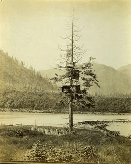
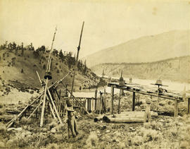
Salmon Caches on the Fraser River

Photograph shows Alexandra Bridge in the background

Steamer "Skuzzy" 31 miles above Yale
Photograph shows supplies being off-loaded from the paddle-wheeler
Trail over the big tunnel 15 miles above Yale
Photograph shows a pack-horse train
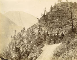
Bluffs, 2 1/2 miles above Yale looking down valley

C.P.R. cantilever bridge across Fraser River 52 miles above Yale

Pitt River Bridge - C.P.R. Railway - 7 miles above Port Moody
Suspension bridge from railroad side of river looking up
Photograph shows the Alexandra Bridge

Tunnel No. 2 and Yale looking down valley from far side of river

Tunnel No. 1 and Yale looking down valley

Black Canyon and railway grade looking down valley from 17th mile post on wagon road

Tunnels, 11, 12 and 13 looking up river from top of Tunnel No. 10 - 10 3/4 miles above Yale

C.P.R. cantilever bridge across Fraser River 52 miles above Yale
![[Stage coach drawn by four horses]](/uploads/r/null/3/a/e/3ae8d2cac722ac909125c07c470e3d888feef4edd583afe2cbb18d3ad0c7d83b/b3018839-7be0-4c34-a57d-8f8e9c061936-CVA12-1_142.jpg)
[Stage coach drawn by four horses]

Interior of Snow Shed C.P.R. Selkirks

Mt. McDonald summit of Selkirks. Height 9440 ft.
Photograph shows the Rogers Pass railroad station and Mount Carrall

Surprise Creek Bridge C.P.R. Selkirks Height 157 feet
![The Scuzzey [Skuzzy] River and Bridge C.P.R.](/uploads/r/null/4/c/4cb0f2b8ee8fa0a30395b55c7f5101c4f51770c445cc436aec17505d3634ad25/d70c4e68-797a-4c60-91d9-aa08582ef0f1-A71355_142.jpg)
The Scuzzey [Skuzzy] River and Bridge C.P.R.

View on C.P.R. Showing Four Tunnels
Photograph shows four men on a hand car

C.P.R. Bridge over Fraser River near Cisco

Chinamen Washing for Gold near North Bend
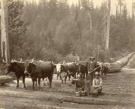
Logging Scene near Vancouver, B.C.
Photograph shows a team of oxen hauling logs on a skid road

Looking Up the Fraser near Yale, B.C.

Mount Sir Donald, C.P.R. Selkirks, Height 10,645 feet
![[Two stages and outriders]](/uploads/r/null/a/3/1/a31fba7504381a2208fd3bb67b5f18dd13a1e9e907be415b3e1e18cc2f83da68/f664d939-e573-4c0b-b0b6-e10df9b86b18-CVA12-3_142.jpg)
![[Celebrated C.P.R. construction locomotive "Old Curly" used for logging, ca 1890]](/uploads/r/null/b/0/c/b0c6ce7293b36290710477e35a1939ef5ec354dcbc838749ec3ee534ec7cc299/c284c8c4-fc87-4588-9eed-16f806c57325-CVA13-1_142.jpg)
[Celebrated C.P.R. construction locomotive "Old Curly" used for logging, ca 1890]
![[Men in a lumber yard]](/uploads/r/null/6/7/6745164da337e67f6053982c624d7d1dc7965e849e909eb4e64f682e64a14f73/f690525d-b3c3-4745-9087-891a428f781c-A71363_142.jpg)
Photograph shows a 36 "x 36" x 60' British Columbia "toothpick"
![Hill's [Hell's] Gate Canyon, Fraser River](/uploads/r/null/c/7/c7f92cbe21a70263cb4b6d5c0c157d12a94237293781fef80d8e2dd972fd1563/10a1c8ab-a1e9-4173-8670-a429a0afc682-A71369_142.jpg)
Hill's [Hell's] Gate Canyon, Fraser River

Illecillewaet Valley from Snow Shed 21
Photograph shows the Illecillewaet (Great) Glacier, the entrance to snow shed 19 with show shed 20 in the background. Photograph may have been taken from the roof of snow shed 18

Salmon in Morrison Creek, Harrison River

Stoney Creek Bridge C.P.R. Selkirks Height 296 feet from below

Stoney Creek Bridge, C.P.R., Selkirks, Height 296 feet

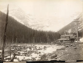
Glacier Hotel and Glacier Selkirks

Hermit Range, Selkirks, from Glacier House

Land Slide on Silver Mountain, Harrison Lake