
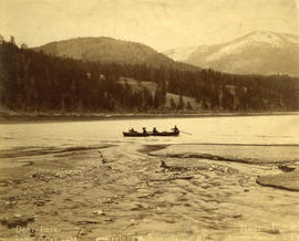
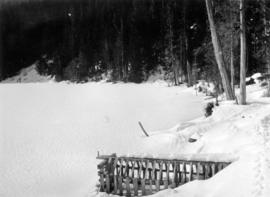
In Camp on Harrison Lake, B.C.
- AM54-S4-: Out P23
- Item
- [1889?]
Part of Major Matthews collection
"Harrison Hot Springs" is written on the side of the tent
174 results with digital objects Show results with digital objects
In Camp on Harrison Lake, B.C.
Part of Major Matthews collection
"Harrison Hot Springs" is written on the side of the tent
Part of City of Vancouver fonds
Item is a map showing the results of a preliminary survey of Cheakamus Lake and surrounding terrain. This map appears to be a draft of potions of the base map for MAP 1077.01, MAP 1077.02 and MAP 1119.

Part of City of Vancouver Archives technical and cartographic drawing collection
Map is a plan showing the location of power houses, dams and pipes for the Garibaldi-Daisy Lake development, Cheakamus Lake-McGuire, McGuire-Brandywine, Cheakamus Canyon and Daisy Lake Dam areas. Map created to accompany E.A. Cleveland's "Report on a Preliminary Investigation of the Cheakamus River Power Possibilities made for the City of Vancouver."

Part of City of Vancouver Archives technical and cartographic drawing collection
Map is a plan of the proposed development of the Cheakamus Lake for hydroelectric power. Includes a capacity diagram of Cheakamus Lake with dam at section A-B and a plan of the proposed dam site. The map also shows elevations and types of terrain. Map created to accompany E.A. Cleveland's "Report on a Preliminary Investigation of the Cheakamus River Power Possibilities made for the City of Vancouver." A note on the map reads "Traverse from Sta. 257-50 to Sta. 371-10 by C.W. Williams 1923, Cheakamus Lake from plan by Williams (1923) except soundings as shown." Map has been numbered Tube 56.

Part of City of Vancouver Archives technical and cartographic drawing collection
Map is a topographical plan showing a proposed hydroelectric development in the Cheakamus River area, between Garibaldi Lake and Daisy Lake, and a profile along the tunnel and pipeline route. Included on the map are Daisy Lake, Garibaldi Lake, Cheakamus River, various creeks, including Parnassus Creek and Scott Creek, bluffs, and ponds. Also indicated on the map are the locations of a pipeline, tunnel and tunnel intake, the Daisy Lake Trail and other trails, a construction shaft, proposed dam, proposed Daisy Lake Reservoir, and the power station for the Garibaldi-Daisy Lake Development. The map was created to accompany E.A. Cleveland's "Report on a Preliminary Investigation of the Cheakamus River Power Possibilities made for the City of Vancouver."

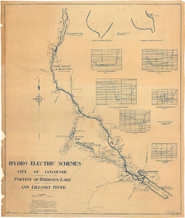
Chilliwack Lake scheme & Jones Lake scheme
Part of City of Vancouver fonds
Item is a map depicting proposed hydro-electric development north-west of Chilliwack Lake. The map shows the location so proposed dams, flumes, tunnels and the location of a power house on the Fraser River west of Jones Lake.

Plan of Pemberton valley from District Lot 758 to Lillooet Lake
Part of City of Vancouver fonds

Nelson, B.C., with Kootenay Lake
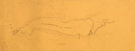
Portion of Harrison Lake and Lillooet River
Part of City of Vancouver fonds
Item is a map sheet survey data from Lilloet Lake in the north to Harrison Lake in the south. The main map show potential dam sites, water levels, bridges and wagon roads. Significant bodies of water included on the map are Harrison Lake, Little Harrison Lake, Glacier Lake, Fire Lake, Lilloet lake, Little Lillooet or Tenas Lake, and Lillooet River. Also shown are Billy Goat Creek, 25 Mile Creek, Rogers Creek, Gowan Creek, Glacier Creek, Spriny Creek, Tipella Creek, Douglas Creek and 6 1/2 Mile Creek. The sheet includes two nautical charts showing depth soundings at the south end of Lillooet Lake and the south end of Tenas Lake. The six sections show depth measured along points on the Lillooet River.
![[View of water intake tower] on Coquitlam Lake](/uploads/r/null/3/5/35ba878ce5089aaf6e7c9e6e22a8bec5ec386033b6125006ebefcedb1b8eb0e2/1ed803c4-bfca-4221-8475-13d60cd76d80-CVA275-32_142.jpg)
[View of water intake tower] on Coquitlam Lake
Burwell Lake, view of Spillway Dam showing leaks

Burwell Lake, view of Crib Dam looking north
Burwell Lake, view of lake north side from Spillway
Burwell Lake, view of Dam face after completion of repairs
![Burwell Lake, view S[outh]. E[ast]. Along east shore of lake](/uploads/r/null/3/1/3151c8f33bc846f38da75ad100fc9be75a2c332d02c5769fd4431e74fb66bc89/0760f179-f6b4-43e4-915a-2947d9e55355-CVA275-29_142.jpg)
Burwell Lake, view S[outh]. E[ast]. Along east shore of lake

Burwell Lake, stream outlet from Burwell Lake before Dam was started
![[Emerald lake in the Rockies]](/uploads/r/null/5/1/51a84e42bc2ecf71331f39b617845a295a624b74cd6efeb00c96927713815a18/34c0aa3f-5ee9-445b-90f0-af00c30db1f0-A20180_142.jpg)

Part of William Orson Banfield fonds

Part of William Orson Banfield fonds

Part of William Orson Banfield fonds
![Lake Buntzen at night during construction of No. 2 [powerhouse]](/uploads/r/null/3/8/5/38526501fc5c20307a8f54c361c10cd615822d2d5cd24c3defa6ee74ead5204d/8a9fae6f-2daa-43fb-9932-67e4002b1efe-CVA289-001_142.jpg)
Lake Buntzen at night during construction of No. 2 [powerhouse]
Part of William Orson Banfield fonds
Part of William Orson Banfield fonds

Part of William Orson Banfield fonds

The side trip to Gold Creek : Alouet Lake
Part of William Orson Banfield fonds

My up-country trip : Long Lake near Vernon
Part of William Orson Banfield fonds

My up-country trip : Long Lake, Vernon
Part of William Orson Banfield fonds

My up-country trip : Long Lake, Vernon
Part of William Orson Banfield fonds

My up-country trip : Long Lake, Vernon
Part of William Orson Banfield fonds

My up-country trip : Kelowna waterfront
Part of William Orson Banfield fonds
My up-country trip : Okanagan Lake near Kelowna
Part of William Orson Banfield fonds

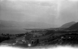
My up-country trip : Okanagan Lake looking north from Kelowna
Part of William Orson Banfield fonds

My up-country trip : Peachland
Part of William Orson Banfield fonds

My up-country trip : Okanagan Lake from Incola Hotel, Penticton
Part of William Orson Banfield fonds

My up-country trip : Penticton from the east
Part of William Orson Banfield fonds
Part of William Orson Banfield fonds

My up-country trip : Chain Lakes
Part of William Orson Banfield fonds

My up-country trip : Otter Lake
Part of William Orson Banfield fonds

My up-country trip : Okanagan Lake
Part of William Orson Banfield fonds

My up-country trip : Naramata from the train
Part of William Orson Banfield fonds

My up-country trip : Summerland and Okanagan Lake from the train
Part of William Orson Banfield fonds

My up-country trip : Kootenay Lake
Part of William Orson Banfield fonds

My up-country trip : Kootenay Lake near Nelson
Part of William Orson Banfield fonds

My up-country trip : Lake boats at Nelson
Part of William Orson Banfield fonds

My up-country trip : Arrow Lake
Part of William Orson Banfield fonds

My up-country trip : Arrow Lake
Part of William Orson Banfield fonds

Part of William Orson Banfield fonds

My up-country trip : Shuswap Lake
Part of William Orson Banfield fonds

My up-country trip : Shuswap Lake
Part of William Orson Banfield fonds