![Sheet 34D [Arbutus Street to 16th Avenue to Trafalgar Street to King Edward Avenue]](/uploads/r/null/d/9/3/d93936674945691b1414267c1a484663e9b4521f5eff49e7df219d736cb81d23/ca0ac406-820e-492a-adc5-fd8619e0e37c-LEG1153_142.jpg)
Sheet 34D [Arbutus Street to 16th Avenue to Trafalgar Street to King Edward Avenue]
- PUB-: PD 2135-: LEG1153.262
- Part
- [ca. 1955] (copied ca. 1980)
Part of City publications collection
264 results with digital objects Show results with digital objects
Sheet 34D [Arbutus Street to 16th Avenue to Trafalgar Street to King Edward Avenue]
Part of City publications collection
![Sheet 34C [Trafalgar Street to 16th Avenue to Blenheim Street to King Edward Avenue]](/uploads/r/null/3/c/e/3ceea778d5a7602e603e5528548ba509862b53454d5d5cef9605f026939a877f/27939355-1f35-4c7c-a59e-c5da77c34f3f-LEG1153_142.jpg)
Sheet 34C [Trafalgar Street to 16th Avenue to Blenheim Street to King Edward Avenue]
Part of City publications collection
![Sheet 35B [Arbutus Street to Oliver Crescent to Trafalgar Street to 33rd Avenue]](/uploads/r/null/1/a/2/1a2dae58c54e4548c9e25079a7b41f6d3472f8dd36ca64d6f04d815f73db8abe/c3e1cf13-4fdf-4061-b0af-8ae3dea6b465-LEG1153_142.jpg)
Sheet 35B [Arbutus Street to Oliver Crescent to Trafalgar Street to 33rd Avenue]
Part of City publications collection
![Sheet 35A [Trafalgar Street to King Edward Avenue to Blenheim Street to 33rd Avenue]](/uploads/r/null/6/4/8/648be52a546b43201063ee32aea015a66237c5ebd207aa6f1c773f9ed5705860/f195e23a-7e01-4b75-9b68-050ee5d330f4-LEG1153_142.jpg)
Sheet 35A [Trafalgar Street to King Edward Avenue to Blenheim Street to 33rd Avenue]
Part of City publications collection
![Sheet 35C [Trafalgar Street to 33rd Avenue to Blenheim Street to 41st Avenue]](/uploads/r/null/2/f/d/2fd752d3f48aa7cecdf56eb40b0a5bde82183a3957844ce8de8abe3f927394b5/6571bf0a-fe92-44d6-8d05-61611fba1aa2-LEG1153_142.jpg)
Sheet 35C [Trafalgar Street to 33rd Avenue to Blenheim Street to 41st Avenue]
Part of City publications collection
![Sheet 35D [Maple Street to 33rd Avenue to Trafalgar Street to 41st Avenue]](/uploads/r/null/7/9/8/7987bd1c1f725393a88386327cd49a88796915b005335815fa2b60292a3be3c1/106eb975-21b1-4180-a45b-60007180aa72-LEG1153_142.jpg)
Sheet 35D [Maple Street to 33rd Avenue to Trafalgar Street to 41st Avenue]
Part of City publications collection
![Sheet 36A [Trafalgar Street to 41st Avenue to Blenheim Street to 49th Avenue]](/uploads/r/null/2/8/4/28460f6a324d3a76d6e4b6164988efd9eae41a90614f984a6108a03436add80d/a5c058b4-8ee2-4bad-b10e-7b990bc2e566-LEG1153_142.jpg)
Sheet 36A [Trafalgar Street to 41st Avenue to Blenheim Street to 49th Avenue]
Part of City publications collection
![Sheet 36B [Maple Street to 41st Avenue to Trafalgar Street to 49th Avenue]](/uploads/r/null/a/4/0/a40c683a4e05e13a0b2788be31d5bd9e052323e28a1c760c2c1370625278ab20/7377513a-5067-46ca-bc51-fb94fc7fdc29-LEG1153_142.jpg)
Sheet 36B [Maple Street to 41st Avenue to Trafalgar Street to 49th Avenue]
Part of City publications collection
![Sheet 36D [Laburnum Street to 49th Avenue to Marine Crescent to 57th Avenue]](/uploads/r/null/c/7/b/c7b470b131a974a25cfdc40ecc04f9e7436cdb7153fc41fce2efe37332fbae5d/ece1b1b3-c1f3-4c8d-9172-ea5f878ec014-LEG1153_142.jpg)
Sheet 36D [Laburnum Street to 49th Avenue to Marine Crescent to 57th Avenue]
Part of City publications collection
![Sheet 36C [Macdonald Street to 49th Avenue to Blenheim Street to 57th Avenue]](/uploads/r/null/5/4/1/54138fec7561b8cf27a9e2fd7bc4302cf88635da8b1ab64a0dc83f55e043b88f/85ab9341-1e7c-4eb0-8827-e02a73e98c76-LEG1153_142.jpg)
Sheet 36C [Macdonald Street to 49th Avenue to Blenheim Street to 57th Avenue]
Part of City publications collection
![Sheet 37A [Macdonald Street to 57th Avenue to Blenheim Street to Fraser River]](/uploads/r/null/9/5/a/95aa079bef47009f14df3f8771db0039f5737dd4c69e6853618c42969bdb4f28/b8c6caea-b7c9-43ee-8721-d033baaa1605-LEG1153_142.jpg)
Sheet 37A [Macdonald Street to 57th Avenue to Blenheim Street to Fraser River]
Part of City publications collection
![Sheet 37B [Arbutus Street to 57th Avenue to Macdonald Street to Fraser River]](/uploads/r/null/8/9/6/896b19b19be5990995a1cc1650cc56b8b95b41edabc7275d7599ff9daba24a10/6fa43256-5f1f-4c4e-8827-d31f15059905-LEG1153_142.jpg)
Sheet 37B [Arbutus Street to 57th Avenue to Macdonald Street to Fraser River]
Part of City publications collection
![Sheet 38A [Wallace Street to English Bay to Discovery Street to Point Grey Road]](/uploads/r/null/3/8/f/38f7cee0d8d7652a09e55d556882175be49a35f450edbdae8537cf4bb5020953/7200fed2-d028-45f4-9c42-ddb263833ea1-LEG1153_142.jpg)
Sheet 38A [Wallace Street to English Bay to Discovery Street to Point Grey Road]
Part of City publications collection
![Sheet 38B [Blenheim Street to English Bay to Wallace Street to 1st Avenue]](/uploads/r/null/7/1/c/71c5407e67cc3bff4e6b39267909502a9758927b3486198fad64719913492e16/8d7dae69-670c-4866-83fd-de62092e22e8-LEG1153_142.jpg)
Sheet 38B [Blenheim Street to English Bay to Wallace Street to 1st Avenue]
Part of City publications collection
![Sheet 37D [Arbutus Street to SW Marine Drive to Yew Street to Fraser River]](/uploads/r/null/e/5/a/e5aa2aae86553141e6823eeb67fd0bb9703daffd5797730546a140a6385f3969/3923280b-492e-4b85-8046-96702ef629fa-LEG1153_142.jpg)
Sheet 37D [Arbutus Street to SW Marine Drive to Yew Street to Fraser River]
Part of City publications collection
![Sheet 38C [Wallace Street to 2nd Avenue to Discovery Street to 10th Avenue]](/uploads/r/null/0/d/a/0da3214ef3428e25131b7b886736d51eea93a3faa646d4436cfb4209cd137dd3/71f51381-e004-4c8d-8c48-75cfe95363d4-LEG1153_142.jpg)
Sheet 38C [Wallace Street to 2nd Avenue to Discovery Street to 10th Avenue]
Part of City publications collection
![Sheet 38D [Blenheim Street to 1st Avenue to Wallace Street to 10th Avenue]](/uploads/r/null/2/4/a/24a75dbb7f7bbe44a899c43d154e4ca6379e01a60c49e440460c0a47aae9d526/e23bc31f-1f4e-4e9c-9170-7bca8fc14020-LEG1153_142.jpg)
Sheet 38D [Blenheim Street to 1st Avenue to Wallace Street to 10th Avenue]
Part of City publications collection
![Sheet 39B [Blenheim Street to 10th Avenue to Wallace Street to 16th Avenue]](/uploads/r/null/b/8/e/b8e886c2e0544e1fcda547b926b902923ea6af25ef89e2aced11cf73832c5930/841000f9-3cf2-40b4-ace7-9c69ed16d64d-LEG1153_142.jpg)
Sheet 39B [Blenheim Street to 10th Avenue to Wallace Street to 16th Avenue]
Part of City publications collection
![Sheet 39A [Wallace Street to 10th Avenue to Discovery Street to 16th Avenue]](/uploads/r/null/d/e/6/de6660a119a0cdd1d10c1297f2cf1c2b4552e9ddec3edf92644013f9cc15e2e1/07059a40-a2f4-4334-9056-d62c618151ec-LEG1153_142.jpg)
Sheet 39A [Wallace Street to 10th Avenue to Discovery Street to 16th Avenue]
Part of City publications collection
![Sheet 39C [Wallace Street to 16th Avenue to Discovery Street to King Edward Avenue]](/uploads/r/null/2/5/c/25c5aa22e403558f96fbd40e3ae0947be0ace24e232e953b87a2fb754b3fb1a3/ff315df3-3abc-48e3-b95c-305139a29e88-LEG1153_142.jpg)
Sheet 39C [Wallace Street to 16th Avenue to Discovery Street to King Edward Avenue]
Part of City publications collection
![Sheet 39D [Blenheim Street to 16th Avenue to Wallace Street to King Edward Avenue]](/uploads/r/null/0/6/5/0655bd0bc18c1c8d272023db21bec0565c5601b72c35586e5a716935161e4650/caafb621-700d-4541-8b4d-320e88161db9-LEG1153_142.jpg)
Sheet 39D [Blenheim Street to 16th Avenue to Wallace Street to King Edward Avenue]
Part of City publications collection
![Sheet 40A [Wallace Street to King Edward Avenue to Univsity Endowment Lands to 33rd Avenue]](/uploads/r/null/f/1/f/f1fd90433a6a288ac0a5c1cf28ccdf3020b21d50e9ccff5ce6c7f752a26ab030/c53b5933-6833-4457-8b54-75aa04b81180-LEG1153_142.jpg)
Sheet 40A [Wallace Street to King Edward Avenue to Univsity Endowment Lands to 33rd Avenue]
Part of City publications collection
![Sheet 40D [Blenheim Street to 33rd Avenue to Wallace Street to 41st Avenue]](/uploads/r/null/3/7/3/3739bbdbc18fbe16d7162de0c6e02dde7965bc02d740ce4e4df465537ac85e04/89aa8116-832b-4979-9033-15d44b002b1f-LEG1153_142.jpg)
Sheet 40D [Blenheim Street to 33rd Avenue to Wallace Street to 41st Avenue]
Part of City publications collection
![Sheet 40B [Blenheim Street to King Edward Avenue to Wallace Street to 33rd Avenue]](/uploads/r/null/a/d/0/ad02d0ef5c1b93f161c46247cc4614b2d56e9cd6a9ff6160d8287e89942f9956/9dd41d25-161b-4003-854d-d02e9a9898ff-LEG1153_142.jpg)
Sheet 40B [Blenheim Street to King Edward Avenue to Wallace Street to 33rd Avenue]
Part of City publications collection
![Sheet 40C [Wallace Street to 33rd Aenue to University Endowment Lands to 41st Avenue]](/uploads/r/null/8/5/6/856a4a832f68fa55c97dfecc6eed8ea78f09e3a96b2c14401b6340f61ae6fff8/85d634e1-5e30-45cf-a659-80c3efa9bf27-LEG1153_142.jpg)
Sheet 40C [Wallace Street to 33rd Aenue to University Endowment Lands to 41st Avenue]
Part of City publications collection
![Sheet 41A [Wallace Street to 41st Avenue to Musqueam Reserve to 49th Avenue]](/uploads/r/null/d/7/f/d7f1e8bd92ef76bcd7457d96a14646d040f9cc8a043fa474a88dbf056606dd90/cbe2dfc1-4957-4833-9e0f-6bb7f1d3c6a8-LEG1153_142.jpg)
Sheet 41A [Wallace Street to 41st Avenue to Musqueam Reserve to 49th Avenue]
Part of City publications collection
![Sheet 41B [Blenheim Street to 41st Avenue to Wallace Street to 49th Avenue]](/uploads/r/null/7/b/2/7b2dd608c9e447bf448dcfc09ed76f8691e4c1e216e012b1b2e2776c5196a218/ad8b9cc6-c5a4-4aa4-8286-2fb92afe4f82-LEG1153_142.jpg)
Sheet 41B [Blenheim Street to 41st Avenue to Wallace Street to 49th Avenue]
Part of City publications collection
![Sheet 41D [Blenheim Street to 49th Avenue to Musqueam Reserve to Fraser River]](/uploads/r/null/e/9/2/e92fc5827e22fcead9e0370739bc0dfbf09b3591c72f423289effff3fdd52ebe/55542ee4-2c2b-4357-ad50-9c533e59a857-LEG1153_142.jpg)
Sheet 41D [Blenheim Street to 49th Avenue to Musqueam Reserve to Fraser River]
Part of City publications collection
![Sheet 42B [Blenheim Street to Celtic Avenue to Fraser River]](/uploads/r/null/d/0/f/d0f904ceb3f9e449b3756ccfde3fdf618ac91b559883559e2cc0e567d57d7a15/c8590d75-7fb0-42c1-b582-67f9b91bfed6-LEG1153_142.jpg)
Sheet 42B [Blenheim Street to Celtic Avenue to Fraser River]
Part of City publications collection
![Sheet 43A [Blanca Street to English Bay to University Endowment Lands to 2nd Avenue]](/uploads/r/null/1/c/b/1cb8433ea45730d34fcc1fe1f92271f79a3eaa3903473a761e4f878170fa5191/ff8939af-97c6-4154-acc1-0d8a868fc66f-LEG1153_142.jpg)
Sheet 43A [Blanca Street to English Bay to University Endowment Lands to 2nd Avenue]
Part of City publications collection
![Sheet 43B [Discovery Street to English Bay to Blanca Street to 2nd Avenue]](/uploads/r/null/2/1/0/21007a691605ce3411c27c74a7e68e1ecc145d09c86feadc96ecb9b090f3c96e/bff71469-8c56-4157-b106-946d78ab28bd-LEG1153_142.jpg)
Sheet 43B [Discovery Street to English Bay to Blanca Street to 2nd Avenue]
Part of City publications collection
![Sheet 43C [Blanca Street to 2nd Avenue to University Endowment Lands to 10th Avenue]](/uploads/r/null/8/e/a/8ea10dc3c6492327a5e0addd9018cab3617de431e837beda4233bb94d8c2db98/d339ad6e-552a-4c6c-a353-a547405cbf57-LEG1153_142.jpg)
Sheet 43C [Blanca Street to 2nd Avenue to University Endowment Lands to 10th Avenue]
Part of City publications collection
![Sheet 44B [Discovery Street to 10th Avenue to Blanca Street to 16th Avenue]](/uploads/r/null/0/f/7/0f7db59d1a90e970d1a27d525155c52735957e90e75e1142b86be956483805d9/ff72da6d-d789-4ce6-9b3d-9361505882c7-LEG1153_142.jpg)
Sheet 44B [Discovery Street to 10th Avenue to Blanca Street to 16th Avenue]
Part of City publications collection

North America. West Coast. Fraser River and Burrard Inlet
Part of City of Vancouver Archives technical and cartographic drawing collection
Item is a nautical chart which show details of area surveyed from Pitt Lake in the north to Roberts Bank in the south and from (what is now) Harrison Hot Springs in the east to Bowen Island in the west. The chart shows soundings in Burrard Inlet, and along the Fraser River.

Garibaldi Lake study 1932-1933
Part of City of Vancouver fonds
Item is a graph depicting gauge water heights for Lesser Garibaldi Lake, Garibaldi Lake, Upper Rubble Creek, Lower Rubble Creek for the period Apr. 1932 to Apr. 1933.

Chilliwack Lake scheme & Jones Lake scheme
Part of City of Vancouver fonds
Item is a map depicting proposed hydro-electric development north-west of Chilliwack Lake. The map shows the location so proposed dams, flumes, tunnels and the location of a power house on the Fraser River west of Jones Lake.
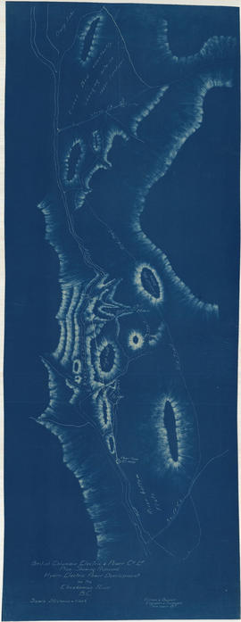
Plan shewing proposed hydro-electric power development on the Cheakamus River B.C.
Part of City of Vancouver fonds

Plan of Pemberton valley from District Lot 758 to Lillooet Lake
Part of City of Vancouver fonds

Part of City of Vancouver fonds
Item is an architectural drawing sheet depicting a plan and section of the intake on the Bridge River, and the power house on Seton Lake.

Plan of proposed development of hydro-electric power. Bridge River
Part of City of Vancouver fonds
Item is a map sheet containing a plan and profile of a proposed hydro-electric development tunneling water from the Bridge River to a power plant on Seton Lake. The main map shows the plan of the overall development; the inset map is a Key Plan showing the location of the development within British Columbia.

Lower Lillooet River - Harrison Lake to Tipella trail
Part of City of Vancouver fonds

Lower Lillooet River - Tipella trail to Bear Lake
Part of City of Vancouver fonds

Lower Lillooet River - Bear Lake to Gowan Creek
Part of City of Vancouver fonds

Lower Lillooet River - Gowan Creek to Rogers Creek
Part of City of Vancouver fonds

Lower Lillooet River - Rogers Creek to Billygoat (29 Mile) Creek
Part of City of Vancouver fonds

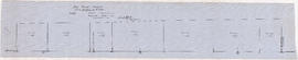
Profile 6 Mile Creek from 2+4240 to 3+1990
Part of City of Vancouver fonds

Profiles of sections of Green & Soo Rivers
Part of City of Vancouver fonds

Part of City of Vancouver fonds
Item is a map sheet containing two profiles: one showing the increased reservoir height with a subsidiary dam built and the other a profile of the proposed subsidiary dam site.
Soo River profile from 6+3820 to 9+2380
Part of City of Vancouver fonds

Profile on possible dam sites across Soo River at 2+4340
Part of City of Vancouver fonds