
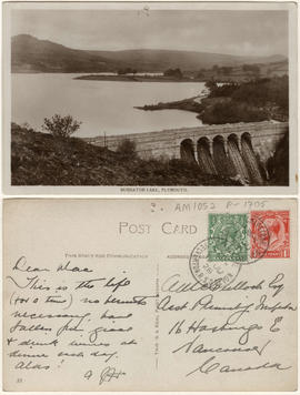
- AM427-S4-F5-: CVA 289-005.576
- Item
- [ca. 1939]
Part of William Orson Banfield fonds
174 results with digital objects Show results with digital objects
Part of William Orson Banfield fonds

The start of the lake behind the dam
Part of William Orson Banfield fonds

Part of William Orson Banfield fonds

Part of William Orson Banfield fonds

Part of William Orson Banfield fonds

Part of William Orson Banfield fonds

Part of William Orson Banfield fonds
Part of City of Vancouver fonds
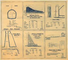
Item is an architectural drawing sheet with six drawings related to proposed hydro electric development on the Chilliwack River: Tunnel section; Spillway section-rock-filled timber crib dam at Chilliwack Lake; Tunnel intake; Tunnel outlet & surge tank; Diversion & storage dam; and Power house and tailrace. Each drawing includes cost and quantity estimates for construction materials.

Hydro electric survey City of Vancouver : Cheakamus River system from Squamish River to Green River
Part of City of Vancouver fonds
Item is a map which shows a proposed hydro electric development of the Cheakamus River system from the Squamish River to Green Lake. The map includes proposed tunnel routes, diversions, storage reservoirs, dams, power houses, canals, and pipelines. Also shown are areas of suggested future development and the Pacific Great Eastern railway line. Included in the area surveyed are Garibaldi Lake, Starvation Lake, Deadman's Lake, Daisy Lake, Stoney Lake, Cheakamus Lake, Alta Lake, Nita Lake, Alpha Lake, and Green Lake, as well as the Squamish River, Pilchuk River, Cheakamus River, Soo River, Green River, and various creeks. Map is hand coloured with pencil annotations concerning watersheds, land height and creeks not included on the original map design.

Hydro electric survey City of Vancouver : Cheakamus River system from Squamish River to Green River
Part of City of Vancouver fonds
Item is a map which shows a proposed hydro electric development of the Cheakamus River system from the Squamish River to Green Lake. The map includes proposed tunnel routes, diversions, storage reservoirs, dams, power houses, canals, and pipelines. Also shown are areas of suggested future development and the Pacific Great Eastern railway line. Included in the area surveyed are Garibaldi Lake, Starvation Lake, Deadman's Lake, Daisy Lake, Stoney Lake, Cheakamus Lake, Alta Lake, Nita Lake, Alpha Lake, and Green Lake, as well as the Squamish River, Pilchuk River, Cheakamus River, Soo River, Green River, and various creeks.

Part of George Thompson fonds

Yaletown Productions Inc. Highland Valley Copper - "A Temporary Use of the Land"
Part of Yaletown Productions Inc. fonds
Itemis a promotional short, titled "A Temporary Use of the Land," produced by Yaletown Productions for Highland Valley Copper (Cominco), Logan Lake, B.C.

Have Camera Will Travel - Art Brewer, assignment "Palau"
Part of Yaletown Productions Inc. fonds
Item is "Have Camera, Will Travel" with Art Brewer, assignment "Palau;" a one hour network television documentary shot and completed in High Definition in 2003. Broadcast first on NHK Japan. High Definition 59.94 1080i Digital Master textless version. HD Cam. Ch 1-2 Full Mix Stereo. - Ch 3-4 M&E Stereo. The film follows Brewer as he takes photographs for the travel magazine "Islands" in Palau. Palau is shot from the air, the water and on land - Art overcomes bad weather and illness to get the shots he wanted and he takes the time to share his process with the audience a little. The show also offers a brief history of Palau and a look into Palau culture. Broadcast first on NHK [Nippon H?s? Ky?kai; official English name: Japan Broadcasting Corporation] Japan. High Definition 59.94 1080i Digital Master textless version. HD Cam. Channel 1 full mix stereo left; channel 2 fill mix sterol right; channel 3 M&E stereo left; and channel 4 M&E stereo right. Facility: Post Digital Works Ltd. Nov. 8, 2002.
![P3 - Mike Collier - MC [Mike Collier] at work and Jason Pitt lk [lake]- w/p [workprint] - film l...](/uploads/r/null/1/9/1956948/30d5ceda-5342-42bb-926a-045fcfe17fc9-MI-582_142.jpg)
Part of Yaletown Productions Inc. fonds
Item is a home movie. Includes footage of Michael Collier and others working on films, Collier and other fishing and Jason Collier.
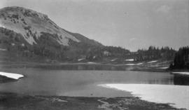
Garibaldi camping photographs, ca. 1927-1931
File consists of photographs that belonged to Society members Mr. and Mrs. Johns (Samuel Curtis Johns and Elizabeth Johns) showing various scenes of camping and hiking trips taken around British Columbia and the Garibaldi park region.
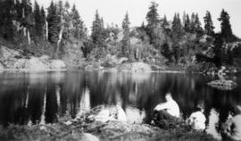
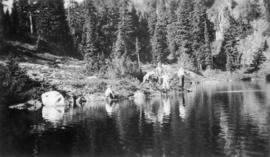
Camping photographs, ca. 1927-1931
File consists of photographs that belonged to Society members Mr. and Mrs. Johns (Samuel Curtis Johns and Elizabeth Johns) showing various scenes of camping and hiking trips taken around British Columbia, including Garibaldi Park, Botanie Mountain, Lytton, Pemberton, Hollyburn Mountain in North Vancouver although the bulk of these photographs consist of unidentified locations.
Tenquille [Tenquille Lake area photographs, ca. 1931]
File consists of photographs that belonged to Society members Mr. and Mrs. Johns (Samuel Curtis Johns and Elizabeth Johns) showing various scenes of camping and hiking trips taken around British Columbia and the Tenquille Lake region.
![Burwell Lake, view N[orth. W[est]. [north east?] along Dam face showing lake at its original wate...](/uploads/r/null/5/1/512924ce9846db6e812b5cd4146af1b202a8bf36b1f63f48d1666f0f3d6255b8/c56c1672-36d7-465d-afb4-dcc7bd262245-CVA275-28_142.jpg)
![Alouet [Alouette] Lake](/uploads/r/null/3/5/d/35d07e70a6eec4b2ed7d4908a502a02885bf1550b53911c59b0177c0661b72f7/61c2489d-499a-4835-bc4f-c9cb255d4683-CVA289-002_142.jpg)
Part of William Orson Banfield fonds

Plan and profile from Cultus Lake to Vedder Crossing
Part of City of Vancouver fonds
Item is a map sheet that contains one main map showing the area between Cultus Lake and Vedder Crossing. The sheet also contains four cross-sections of the Chilliwack River. The map appears to be a draft version of MAP 1118.

Plan and profile from Cultus Lake to Vedder Crossing
Part of City of Vancouver fonds
Item is a map sheet that contains one main map showing the area between Cultus Lake and Vedder Crossing. The sheet also contains four cross-sections of the Chilliwack River. MAP 1117 appears to be a draft version in the hand of the surveyor, H. Idsardi.

Profile of Lillooet River from Tenas Lake to Harrison Lake
Part of City of Vancouver fonds
Item is a map sheet showing a profile of the Lillooet River and cross-sections at the following locations: 210+00, 320+00, 383+00, 534+00, 1005+00 and the bridge at 1350+00.
Part of City of Vancouver fonds
Item is a portion of a topographical map showing Green Lake, the headwaters of the Green River, and the portions of 21 Mile Creek and Fitzsimmons Creek where they empty into Green Lake. The remaining portion of the map shows the Green Lake area from District Lot 2015 to 3336. The map is missing its right-hand portion and title block, though the style and hand are the same as other maps created by the City Engineer's Office as a result of the 1923 surveys of the Squamish, Cheakamus and Green rivers.
The sheet also contains three sections: one of Fitzsimmons Creek at the Pacific Great Easter Railway bridge 40.5, one of the Green River and one of the valley north-west of Green Lake along which the PGE line runs.
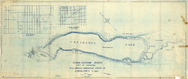
Hydro electric survey. Plan showing preliminary survey of Cheakamus Lake
Part of City of Vancouver fonds
Item is a topographical map showing a preliminary hydro electric survey of Cheakamus Lake, including a capacity diagram of Cheakamus Lake with dam at Section A-B and a cross-section on that line. The sheet includes a graph depicting the capacity of Cheakamus Lake with dam at section A-B. The map includes the Cheakamus River, creeks, characteristics of the terrain, elevations, and water level. Certified correct by Charles W. Williams.
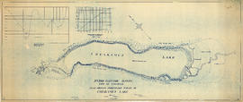

Hydro electric surveys. Plan showing location of water powers investigated by City of Vancouver
Part of City of Vancouver fonds
Item is a map which functions as a visual index to the locations of various hydro electric surveys carried out by the City of Vancouver along the following rivers: Squamish River, Cheakamus River, Green River, Lillooet River, Eagle River, Indian River, Pitt River, Chehalis River, Harrison River, Chilliwack River, the Fraser and Thompson Rivers, and Bridge River. The map lists the names of the surveyors responsible and the areas covered by each survey. Annotations include the locations and the dates of use of "gauging stations established" and "city gauging stations still in use."

Hydro electric surveys. Plan showing location of water powers investigated by City of Vancouver
Part of City of Vancouver fonds
Item is a map which shows the locations and the dates of use of "gauging stations established" and "city gauging stations still in use" in the area of south-western British Columbia where the City of Vancouver conducted hydro-electric surveys up to 1923.

Plan of Pemberton valley from District Lot 758 to Lillooet Lake
Part of City of Vancouver fonds

Plan of Pemberton valley from District Lot 758 to Lillooet Lake
Part of City of Vancouver fonds
Chehalis River and Harrison Lake
Part of City of Vancouver fonds
Item is a map sheet containing draft or preliminary versions of maps of the Chehalis River and Harrison Lake, relating to surveys conducted by H. Idsardi.
Plan shewing road traverse & levels from Agassiz to Harrison Lake
Part of City of Vancouver fonds
Item is a map sheet containing a main map showing the proposed hydro-electric development near Agassiz, B.C., a detail map of the development and two cross-sections of the Harrison River. The map appears to be a preliminary version of MAP 1112, drawn by surveyor H. Idsardi, for the City Engineer's Office to use as the basis for MAP 1112.

Part of Yaletown Productions Inc. fonds
Item is camera original raw footage for "Curse of the Lost Gold Mine." Includes an interview with John F. H. Thompson, a geologist at UBC, who talks about the geology of Pitt Lake, shots of a map of Pitt Lake and Michael Collier plotting out a route on the map, also includes an interview with Mike Boileau, who has been looking into finding gold in the Pitt Lake area since 1979, he talks about the curse, the stories of Pitt Lake, and his own experiences at Pitt Lake.
Lost Mine - tape 6 ; Jack Mould and Don Waite
Part of Yaletown Productions Inc. fonds
Item is camera original raw footage for "Curse of the Lost Gold Mine." Footage includes an interview with Jack [Mould] who is standing beside the tent-shaped rock that he and his partners removed from the Pitt Lake area. In addition there are shots of Michael Collier listening to Jack and the tent-shaped rock on its own. Don Waite, Kathie Hamilton, Dick Hamilton and Michael walking along the Pitt Lake lakeshore, and Don shares stories about Slumach and the lost mine legend.
![The curse of the lost [gold] mine - tape #206](/uploads/r/null/1/2/1228660/13a5f9b6-9c2f-4e68-a792-84565a87def2-MI-478_142.jpg)
The curse of the lost [gold] mine - tape #206
Part of Yaletown Productions Inc. fonds
Item is a copy of original film shot for the docudrama "Curse of the lost gold mine." Includes nature and wildlife scenes with no people in them as well as shots of people hiking with packs and a log cabin. Includes some mountain scenes shot from a helicopter [or airplane].
![The curse of the lost [gold] mine - tape 7 ; Interview Don Waite](/uploads/r/null/1/2/1228674/b536c8ac-7b1e-4527-b037-01736834184e-MI-489_142.jpg)
The curse of the lost [gold] mine - tape 7 ; Interview Don Waite
Part of Yaletown Productions Inc. fonds
Item is camera original raw footage for "Curse of the Lost Gold Mine." Footage includes an interview of [Don Waite] and scenic footage of the Pitt Lake area. Also includes footage in the library with Michael Collier, Kathie Hamilton, and Dick Hamilton. Michael Collier and Dick Hamilton both briefly speak to the camera about the planned expedition to the Pitt Lake area.
![The Curse Of The Lost [Gold] Mine - tape 316 ; 1975 expedition](/uploads/r/null/1/2/1228695/0d738ff5-c33a-42ea-a050-5e7fa9d3a8a9-MI-480_142.jpg)
The Curse Of The Lost [Gold] Mine - tape 316 ; 1975 expedition
Part of Yaletown Productions Inc. fonds
Item is a copy of original film shot for the docudrama "Curse of the Lost Gold Mine." Includes scenes of men with packs [including Dick Hamilton] hiking and climbing on and near a glacier, the men examine silt and rocks, hike in a rocky area, some morning campsite scenes.
![The Curse of the Lost [Gold] Mine - tape 9 ; Library](/uploads/r/null/1/2/1228709/d9f871e5-e850-4d41-a3d3-1f33ed5ecc7c-MI-491_142.jpg)
The Curse of the Lost [Gold] Mine - tape 9 ; Library
Part of Yaletown Productions Inc. fonds
Item is camera original raw footage for "Curse of the Lost Gold Mine." Includes scenes shot at an archives with an actor reading the contents, and of the actual documents and newspaper articles (this footage is mainly silent). Footage switches abruptly to a water scene and people driving away in a boat. Then there is an interview with some Katzie First Nations elders: [Agnes Pierre], [Mel Bailey], and [Ken Florence].
![The curse of the lost [gold] mine - tape 315](/uploads/r/null/1/2/1228716/4960b310-2233-4efa-9133-5e1dd7b43629-MI-479_142.jpg)
The curse of the lost [gold] mine - tape 315
Part of Yaletown Productions Inc. fonds
Item is a copy of original film shot for the docudrama "Curse of the lost gold mine." Includes scenes of men with packs being taken by helicopter to a mountain area and left there. Scenes of three people [including Dick Hamilton who is involved in both the 1970s and 1990s efforts to make this film] hiking through beautiful nature areas and setting up camp. The men look at a map together, cook food, explore a cave, and spend some time hiking on a glacier and exploring formations and cracks.
This postcard includes personal correspondence addressed to Culloch, Assistant Plumbing Inspector, of Vancouver.

Photograph shows house near the lake
![Botahnie [Botanie] Lake](/uploads/r/null/c/0/e/c0e5167d9f8ec765ddc2598f76c81d19fce9c1a5427f92f4aa2910932c57f91d/1809a339-5297-44b7-8a1e-3386be98462e-2005-040_142.jpg)


Part of City of Vancouver Archives sound recording and moving image collection
Item is a film containing part 3 of We Drivers. The film opens with the Inter-title: "Having said goodbye to the cowboys, we go to the Arrow Lakes." Film contains footage showing the sternwheeler S.S. "Minto", Nakusp, scenes of lakes and towns, a steamboat, Arrow Park, Carrolls Landing, Burton, Penticton, beach scenes and the return to Vancouver. Produced for Trimble Service Garage.