- AM1663-: CVA 300-113
- Item
- [between 1936 and 1938]
Part of Karl Haspel fonds
2306 results with digital objects Show results with digital objects
Part of Karl Haspel fonds
Vancouver Cityscapes - Downtown, Fairview, Mount Pleasant
Part of City of Vancouver fonds
Item is a set of negatives of cityscape photographs taken mostly from the upper floors of the Plaza 500 Hotel & Convention Centre at 500 W. West 12th Avenue, at the intersection of West 12th Avenue and Cambie Street, looking north. The subject material of the photographs is predominantly downtown Vancouver, the North Shore Mountains, False Creek, and the Fairview and Mount Pleasant neighbourhoods. This set contains the raw photographs from the roll the photographer shot in their original order. The associated contact sheet has selection marks for frames 16, 21, 23, and 25.
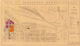
Part of City of Vancouver fonds
Item is a map showing boundaries of redevelopment and clearance areas, proposed land use, new streets and lanes, sites not to be acquired, and buildings to be retained in project 2. Map has been annotated with colour indicating land use and a proposed widening of Scotia Street. Base map shows building outlines and topographic contour lines, and covers the area bounded by Main Street, Clark Drive, Terminal Avenue, and Broadway

City of Vancouver redevelopment : project 2, area "H" and part of "B" : identification plan
Part of City of Vancouver fonds
Item is a map showing boundaries of clearance areas and ownership of property included in the acquisition program. Map has been annotated to show a possible amendment to the clearance area boundaries and a proposed widening of Scotia Street. Base map shows building outlines and topographic contour lines, and covers the area bounded by Main Street, Clark Drive, Terminal Avenue, and Broadway

Urban renewal scheme 3 : Mt. Pleasant 2 : apartment development
Part of City of Vancouver fonds
Item is a map annotated to show dates of construction of apartment buildings in the area bounded by Scotia Street, Clark Drive, Great Northern Way, and Broadway. Base map shows streets, building outlines, and topographical contour lines.

Part of City of Vancouver Archives technical and cartographic drawing collection
Item consists of a planning map depicting the eastern portion of False Creek and surrounding areas.

Part of City of Vancouver Archives technical and cartographic drawing collection
Item consists of a large scale site plan, depicting a proposed development in False Creek [Expo 86?] annotated on top of what appears to be a City planning map. The plan appears to depict part of the Concord Pacific development.

Urban renewal scheme 3 : Mt. Pleasant 2 : existing land use
Part of City of Vancouver fonds
Item is a map annotated to show types of land use in the area bounded by Scotia Street, Clark Drive, Great Northern Way, and Broadway. Base map shows streets, building outlines, and topographical contour lines.

Urban renewal scheme 3 : Mt. Pleasant 2 : conditions of residential building
Part of City of Vancouver fonds
Item is a map annotated to show condition of residential buildings in the area bounded by Scotia Street, Clark Drive, Great Northern Way, and Broadway. Base map shows streets, building outlines, and topographical contour lines.

Urban renewal scheme 3 : Mt. Pleasant 2 : conditions of non-residential building
Part of City of Vancouver fonds
Item is a map annotated to show condition of non-residential buildings in the area bounded by Scotia Street, Clark Drive, Great Northern Way, and Broadway. Base map shows streets, building outlines, and topographical contour lines.

Part of City of Vancouver fonds
Item is a map annotated to show the boundaries of Project no. 2 areas 8 and 9. Area 8 corresponds roughly to the area bounded by Scotia Street, Brunswick Street, 2nd Avenue, and 8th Avenue. Area 9 corresponds roughly to the area bounded by Guelph Street, Fraser Street, 5th Avenue, and 7th Avenue. Base map is a reproduction of an aerial photograph showing the area bounded by Main Street, Clark Drive, Terminal Avenue, and Broadway.

Recording of first Centennial song at Griffiths Gibson Productions
Recording of first Centennial song at Griffiths Gibson Productions

Mount Pleasant and False Creek

Vancouver City Hall from the southwest
Part of City of Vancouver fonds
![R.C.M.P. [Royal Canadian Mounted Police] Building, Main Street south entrance](/uploads/r/null/7/8/b/78bfd9357beddc228b5ad9726f607de307afa28829edd3a24c136b54b7882a16/ecded68b-962b-4fa7-a698-1c9b933fa643-CVA70-12_142.jpg)
R.C.M.P. [Royal Canadian Mounted Police] Building, Main Street south entrance
Part of Art Grice fonds
Item is a photograph of the secondary entrance of the R.C.M.P. building (later, Heritage Hall, 3102 Main Street) at the corner of Main Street and 15th Avenue showing a low angle view of the windows, ceiling, and architectural details above the doorway in the smaller southern tower. Also visible are some of the sculptures decorating the frieze above the second level.
![R.C.M.P. [Royal Canadian Mounted Police] Building, Main Street, north facade and clock tower](/uploads/r/null/f/1/3/f13b3c0d36643beee7d88d19a63a13b1aca3588fc2c2589a01baad7e2530b923/cc2920b3-3d9c-474d-b2c5-38619a59b10f-CVA70-13_142.jpg)
R.C.M.P. [Royal Canadian Mounted Police] Building, Main Street, north facade and clock tower
Part of Art Grice fonds
Item is a photograph of the (northern) clock tower, north facade, and frieze of the R.C.M.P. building (later, Heritage Hall, 3102 Main Street) at the corner of Main Street and 15th Avenue.
![R.C.M.P. [Royal Canadian Mounted Police] Building, Main Street, main entrance](/uploads/r/null/5/b/5/5b50e92503f01bd8a74fc5892f9f3708bb94bc9362fe91870501831f4d5c604c/10505865-147b-4588-98fc-e331a460607f-CVA70-14_142.jpg)
R.C.M.P. [Royal Canadian Mounted Police] Building, Main Street, main entrance
Part of Art Grice fonds
Item is a photograph of the main entrance of the R.C.M.P. building (later, Heritage Hall, 3102 Main Street) at the corner of Main Street and 15th Avenue showing the doorway, columns, windows, and architectural details above the main doorway. Also visible are some of the sculptures decorating the frieze above the second level.
![R.C.M.P. [Royal Canadian Mounted Police] Building, Main Street, clock tower detail](/uploads/r/null/4/7/8/4784077b86de352a04cf10904113237db0b62ab4b677e8244ec70993c8e4d32b/a94b914d-e305-45f2-8e7e-0bb76a62637e-CVA70-15_142.jpg)
R.C.M.P. [Royal Canadian Mounted Police] Building, Main Street, clock tower detail
Part of Art Grice fonds
Item is a photograph of the upper portion of the (northern) clock tower of the R.C.M.P. building (later, Heritage Hall, 3102 Main Street) at the corner of Main Street and 15th Avenue. The item details the clock face, tower roof, flag pole, lightning rods, and other architectural features.
![R.C.M.P. [Royal Canadian Mounted Police] Building, Main Street, west facade](/uploads/r/null/a/d/b/adbc09f89c670832271e75247cbd4dc4e4032bbb8407a3cad970b27809a0edf5/7a73d915-c683-494d-b735-78b65a7f1006-CVA70-16_142.jpg)
R.C.M.P. [Royal Canadian Mounted Police] Building, Main Street, west facade
Part of Art Grice fonds
Item is a photograph of the whole west (Main Street) facade of the R.C.M.P. building (later, Heritage Hall, 3102 Main Street) at the corner of Main Street and 15th Avenue. Both towers, entrances and all architectural features are visible.

City Hall, north facade from lawn
![Vancouver, B.C. Plan showing location of water pipes, hydrants, etc. [Fairview slopes]](/uploads/r/null/6/9/69e0d6904facfa2a814069c15122fba46fc4d8077bff76402e95484a4b13d4d8/313b8940-1e98-45d4-b077-abe0f6bee66a-MAP72_142.jpg)
Vancouver, B.C. Plan showing location of water pipes, hydrants, etc. [Fairview slopes]
Part of City of Vancouver Archives technical and cartographic drawing collection
Item is a map showing the location of water pipes and hydrants for the area bounded by Scotia Street, False Creek, Spruce Street and Tenth Avenue (D.L. 526, D.L. 302 and D.L. 200). Block 6 in D.L. 200 was covered by an overlay depicting a later sub-division. Pipes and hydrants are shown in various coloured inks to indicate installation date. Annotations have been drawn on a base map that was part of a larger map.
Vancouver (B.C.). Water Works Department

Part of City of Vancouver Archives technical and cartographic drawing collection
Item is a map showing the location of water pipes and hydrants for the area from Victoria Drive to False Creek to Prince Edward Street to 16th Avenue (D.L. 264A). Pipes and hydrants are shown in various coloured inks to indicate date of installation.
Vancouver (B.C.). Water Works Department

Mt. Pleasant Queen and attendants before crowning, July 16th
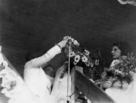
Mt. Pleasant Queen crowned by Mayoress McGeer, July 16th

Mayor McGeer presents oldest lady inhabitant of Mt. Pleasant
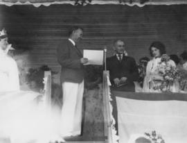
Mayor McGeer presents oldest gentleman inhabitant of Mt. Pleasant

Part of Pacific Press fonds

Streetcar on Kingsway at Main Street
Part of Pacific Press fonds

Streetcars on Kingsway at Main Street, commencement of longest paved highway in the world
Part of Pacific Press fonds

Two women pushing strollers in Robson Park
Part of Pacific Press fonds

Residential street in Mount Pleasant area
Part of Pacific Press fonds
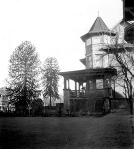
Home with turret and verandah in Mount Pleasant
Part of Pacific Press fonds

Home with stone wall and Evergreen trees in Mount Pleasant
Part of Pacific Press fonds

St. Patrick's School for Girls in Mount Pleasant, with students on steps
Part of Pacific Press fonds

Close-up of students on St. Patrick's School steps in Mount Pleasant
Part of Pacific Press fonds

Florence Nightingale School in Mount Pleasant, showing main entrance with students on steps
Part of Pacific Press fonds
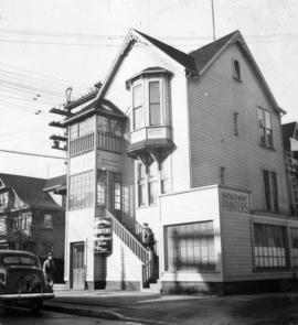
Broadway Printers building exterior
Part of Pacific Press fonds

Mount Pleasant School boy pupils, sitting down outside
Part of Pacific Press fonds

Mount Pleasant School children's outdoor dance class
Part of Pacific Press fonds

Mount Pleasant School children's outdoor dance class
Part of Pacific Press fonds
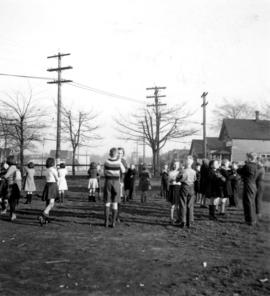
Mount Pleasant School children's outdoor dance class
Part of Pacific Press fonds

Old Beaver dam in Mount Pleasant, with girl by stream
Part of Pacific Press fonds
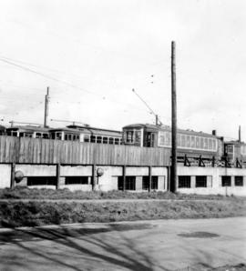
Electric railcars stored in barns above Old Mount Pleasant Beaver dam
Part of Pacific Press fonds

Electric railcars stored in barns above Old Mount Pleasant Beaver dam
Part of Pacific Press fonds

Three children near Old Mount Pleasant Beaver dam
Part of Pacific Press fonds
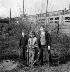
Three children near Old Mount Pleasant Beaver dam
Part of Pacific Press fonds

Man standing beside old granite trough in Mount Pleasant
Part of Pacific Press fonds

Man standing beside old granite trough in Mount Pleasant
Part of Pacific Press fonds
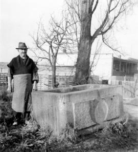
Man standing beside old granite trough in Mount Pleasant
Part of Pacific Press fonds