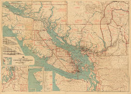
Part contains a commercial and visitors map of the southwestern land districts of British Columbia, encompassing Vancouver Island and the mainland from Seymour Inlet in the northwest to Black Pines in the northeast, extending south to Chiwaukum, Washington. Primary map shows settlements, government agent offices, mining and sub-mining recording offices, game reserves, customs posts, hospitals, ferries, campsites, golf courses, canneries, commercial air harbours, lighthouses, radio stations, motor boat refill stations, power sites, railways, roadways, trails, telegraph and telephone lines, steamship routes, topographic contour lines, and locations of falls and rapids. Text on the map provides information on land features and the presence of wild and farmed animals, and indicates current and possbile agricultural and industrial land use. Inset maps show the northern tip of Vancouver Island, Triangle Island and West and East Haycock Islands, and northwestern Washington State from Seattle to Centralia. A key map shows the location of the area covered by the main map in relation to the rest of North America.


![View on the Chuckanut Drive, Pacific Hiway [Highway]](/uploads/r/null/0/a/1/0a1f1953636564ca1646814e64cd543aec5e12b70d12d5ead5e12114ec2165d1/feb53896-e5dd-42a0-855f-c0967c781f64-CVA289-003_142.jpg)
![View on the Chuckanut Drive, Pacific Hiway [Highway]](/uploads/r/null/b/6/0/b6025b13309e21bdb54af6e223a16ae7ab6bf53a3d09a2def09a8c93166d0ea5/dd783a7b-beab-4ff7-bad9-301024b32a21-CVA289-003_142.jpg)
![View on the Chuckanut Drive, Pacific Hiway [Highway]](/uploads/r/null/4/d/0/4d058fcb9f0d5b32ed97fd9c5af0e35e8283cc8b152eafdd34d5578209db5363/41e49344-b986-472a-9e9e-408f242cb37d-CVA289-003_142.jpg)
![View on the Chuckanut Drive, Pacific Hiway [Highway]](/uploads/r/null/8/a/1/8a1138124e805230ee4e02a2286badfe44ff977e5a46f86409a07f8161f7aa71/cd291a91-4ce1-4e1f-8aeb-db5917ba39b1-CVA289-003_142.jpg)

![[View of Mount Shuksan from the road to Mount Baker]](/uploads/r/null/d/7/d77b6396eecb2d0f09fe1df0a14704f25d6a92df9eb23bf1fc9adae7a87adaa0/b0cecf3c-95b9-48e0-81cf-a5524cdb66dc-A32833_142.jpg)
![Veratrum [at] Mount Baker, Washington](/uploads/r/null/9/c/9c38d8792e2c86902dfa539e3525cd77be414e011c9d1cb0f371b8c9955f3f75/086b1136-c8a9-4d27-abb1-601c25f41ce1-A58335_142.jpg)
![Veratrum [at] Mount Baker, Washington](/uploads/r/null/8/0/80c95d684d66b84d35f9ff795d098fae90d542e9efd215455c701df685169c6d/051712fc-6b92-478a-a2e6-ece0f2ecf2ba-A58334_142.jpg)
![Vaccinium [at] Mount Baker, Washington](/uploads/r/null/3/3/338e12c80bcf0050cb72f9fee4dcc07a6d63e1e11fe4ae1e46a591e9f9700888/539c7e4f-1a83-4682-930e-c61019972a0b-A58319_142.jpg)


![The road at summit [of] Blewet Pass](/uploads/r/null/8/7/a/87af9a01f91e6a639af597d399c2e04b941e6bb36f49e35531f96a2c196a342f/6eb5986e-f3e3-4be3-8663-3b8cfd485586-CVA289-004_142.jpg)
![[The entrance to Fairhaven Park]](/uploads/r/null/d/1/d1bce377719fe72a83156fee9aea583aace0164cc961d110e6a8551a35571d1a/9c2c756b-94f8-4b17-9397-2c86e0a87287-A26812_142.jpg)


![Table M[oun]t[ain]](/uploads/r/null/9/3/f/93f45b7e77f91c47f5825d46db7a4f7a92ca8db083def523a6c7b348e94d30c5/1125e985-3495-40fc-81b4-81f89ec4fe25-CVA289-004_142.jpg)


![Phyllodoce empetriformis, Hurricane Ridge - Olympic Pen[insula]](/uploads/r/null/e/2/e2214854c50ece5526d274af6b748ec02f81df8f96d535fc5831ecd0e298f7ce/c231e151-61e8-4dfb-b2e4-4f15c426fce0-A57201_142.jpg)


![Paeonia suffruticosa [at] US Nat[ional] Arboretum](/uploads/r/null/3/6/3606ad94689fed4f1740c5d2c87ba8439a9e306af33a0c6504995c8199f0bcb9/fc80ad8b-5e31-4462-b96b-2eafc2bc0f2f-A57154_142.jpg)
![Our motor trip to Portland : Looking over [the edge of Inspiration Point]](/uploads/r/null/4/7/2/472bc3865ffb1ee0dd0d5f275b7b8c7196c2155c462f8b518d16213413d5034b/d10ad6d6-c193-41fc-b33b-ee77c0818e95-CVA289-002_142.jpg)
![Our motor trip to Portland : Inspiration Point, Chuckanut Hiway [Highway]](/uploads/r/null/4/e/9/4e99d9d9911ebc87de52381367854969f5d2e67c165a868611d27b0f05f6207d/ab1335f7-2108-4eec-882d-485cd4059503-CVA289-002_142.jpg)
![Our motor trip to Portland : Gwyn [Lewis] going-?](/uploads/r/null/8/3/b/83b79ca98cce8ab981f140f211393d57c9cd253d7d73733be3851a3532f3812b/67dc7352-e7d3-4333-a203-7e21500c0903-CVA289-002_142.jpg)