
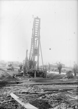
West 3rd Avenue and Arbutus Street looking south down Arbutus
- COV-S371-F39-: CVA 656-19
- Item
- Sept. 23, 1916
Part of City of Vancouver fonds
West 3rd Avenue and Arbutus Street looking south down Arbutus
Part of City of Vancouver fonds
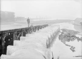
Two men standing on a pier beside a sewer pipe
Part of City of Vancouver fonds
Item is a photograph showing two men at the storm sewer outfall at Heather Street.
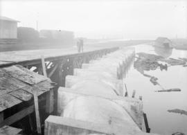
Two men standing on a pier beside a sewer pipe
Part of City of Vancouver fonds

Part of City of Vancouver fonds

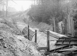
Trench with reinforced wooden boards
Part of City of Vancouver fonds

Part of City of Vancouver fonds

Sewerage system : plan of Point Grey Municipality
Part of City of Vancouver fonds
Item is a map annotated to show the sewer system in Point Grey. Base map was created by the Vancouver Map and Blue Print Co. and shows streets, railways, and district lot and block numbers.

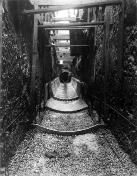
Sewer tunnel with brick siding
Part of City of Vancouver fonds

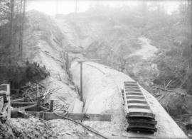
Sewer pipes laid out in open clearing
Part of City of Vancouver fonds

Sewer pipes laid out in open clearing
Part of City of Vancouver fonds
Part of City of Vancouver fonds
Item is a photograph showing the China Creek sewer.
Part of City of Vancouver fonds
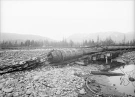
Sewer pipe on trestle under construction
Part of City of Vancouver fonds
Sewer pipe on trestle in open clearing
Part of City of Vancouver fonds

Part of City of Vancouver fonds

Sewer pipe inside reinforced trench at Gilford Street
Part of City of Vancouver fonds

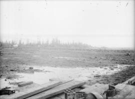
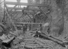
Sewer construction, possibly on Venables Street
Part of City of Vancouver fonds

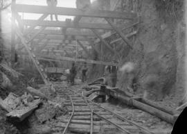
Sewer construction, possibly on Venables Street
Part of City of Vancouver fonds
Sewer construction, possibly on Venables Street
Part of City of Vancouver fonds

Sewer construction, possibly on Venables Street
Part of City of Vancouver fonds
Sewer construction, possibly on Venables Street
Part of City of Vancouver fonds

Sewer construction, possibly on Venables Street
Part of City of Vancouver fonds

Sewer construction, possibly on Venables Street
Part of City of Vancouver fonds

Sewer construction, possibly on Venables Street
Part of City of Vancouver fonds

Sewer construction, possibly on Venables Street
Part of City of Vancouver fonds
Sewer construction, possibly on Venables Street
Part of City of Vancouver fonds

Sewer construction, possibly on Venables Street
Part of City of Vancouver fonds

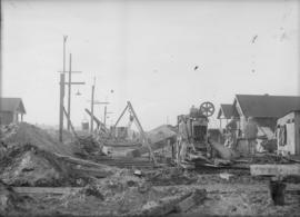
Sewer construction, likely on 6th Avenue
Part of City of Vancouver fonds

Sewer construction on Venables Street east of Penticton Street
Part of City of Vancouver fonds

Sewer construction on Venables Street east of Penticton Street
Part of City of Vancouver fonds

Sewer construction on Venables Street east of Penticton Street
Part of City of Vancouver fonds

Part of City of Vancouver fonds

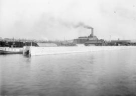
Sewer construction at waterfront
Part of City of Vancouver fonds
![[Sewage] Trench for 4'6" interceptor on 7th Avenue](/uploads/r/null/3/a/3a06f3b91f9f2903314d032b3849c52f12e163f45cc41586ee0e5718e34fc3b5/36252cee-90ab-4b0c-9752-1c01581b2368-CVA275-8_142.jpg)
[Sewage] Trench for 4'6" interceptor on 7th Avenue
Section of 5'0" sewer on Copley Street just north of Lakeview
Reinforcing trench for sewer construction
Part of City of Vancouver fonds
Reinforcing trench for sewer construction
Part of City of Vancouver fonds

Reinforced tunnel for sewer construction
Part of City of Vancouver fonds

Part of City of Vancouver fonds
Item is a map created to depict utilities in the proposed project 2 area 6. The map shows fire alarms, sewer lines, water lines, gas lines, underground telephone lines, underground power lines, underground vaults, and curbs. Also noted are existing buildings which may be cleared in future projects, existing buildings in immediate vicinity of area a-6 which may remain, existing subdivisions to be cancelled, easement boundaries, approximate elevations at street intersections, approximate locations at contours and areas for disposal ("private development" and "public housing").

Proposed system of drainage and sewerage for False Creek and marginal areas
Part of City of Vancouver fonds
Item is a map showing sewers and storm drains in the area from Alexander Street in the north to Seventh Avenue in the south and from Clark Drive in the east to Main Street in the west.
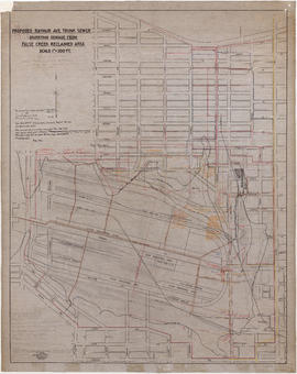
Proposed Raymur Ave. trunk sewer diverting sewage from False Creek reclaimed area
Part of City of Vancouver fonds
Item is a map showing detailed plans associated with the Raymur Ave. trunk sewer. The map contains several revisions and updates dated Dec. 1936, Feb. and Mar. 1937, May 1937, Aug. 1938 and Sept. 1941 of utilities infrastructure in False Creek east of Main Street.
Vancouver (B.C.). Engineer's Office

Proposed Raymur Ave. trunk sewer diverting sewage from False Creek reclaimed area
Part of City of Vancouver fonds
Item is a map showing detailed plans associated with the Raymur Ave. trunk sewer. Annotations show the heights of top fill, bottom and water relative to an unidentified benchmark.
Vancouver (B.C.). Engineer's Office

Proposed Raymur Ave. trunk sewer diverting sewage from False Creek reclaimed area
Part of City of Vancouver fonds
Item is a map showing detailed plans associated with the Raymur Ave. trunk sewer. Annotations show sewer lines.
Vancouver (B.C.). Engineer's Office

Project 2, part of area "a" : utility diversions and rearrangements
Part of City of Vancouver fonds
Item is a map showing boundaries of clearance areas for project 2 (areas 5 (part), 6 and 7) and project 1 (area 3). Maps also show sewers to remain, sewers to be abandoned, water lines to remain, water lines to be abandoned, gas lines to remain, gas lines to be abandoned, power lines existing underground, proposed diversions of power lines, power lines existing overhead, proposed overhead power lines and long distance telephone lines existing underground. Larger map shows area from Hastings Street in the north to Union Street in the south and from Heatley Avenue in the east to Gore Avenue in the west. Smaller map shows area from Powell Street in the north to Hastings Street in the south and from Clark Drive in the east to Glen Drive in the west. Item also shows estimates of costs for utility diversions and rearrangements for areas 5, 6 and 7.
Attached label indicates that the map was approved by Council Sept. 17, 1963.

Project 2, part of area "a" : existing utilities, water and sewer
Part of City of Vancouver fonds
Item is a map showing the configuration of water and sewer services in project 2 area "a". The map depicts the water pipes (10" and over), the sewers (15" and over), and the direction of sewer flow.

Project 2, part of area "a" : existing utilities, water and sewer
Part of City of Vancouver fonds
Item is a map showing the water pipes (10" and over), the sewers (15" and over), the direction of sewer flow, the boundaries of project 2 clearance, the boundaries of project 1 clearance and the realignment of Raymur Avenue in the area from Burrard Inlet in the north to Atlantic Street in the south and from Clark Drive in the east to Main Street in the west.
Attached label indicates that the map was approved by Council Sept. 17, 1963.

Project 2, part of area "a" : existing utilities, gas, electricity and telephone
Part of City of Vancouver fonds
Item is a map showing the gas lines, the overhead and underground electricity lines, the overhead and underground telephone lines, the fire alarms underground, the boundaries of project 2 clearance, the boundaries of project 1 clearance and the realignment of Raymur Avenue in the area from Railway Street in the north to Atlantic Street in the south and from Clark Drive in the east to Main Street in the west.
Attached label indicates that the map was approved by Council Sept. 17, 1963.

Project 2, part of area "a" : existing gas, electricity and telephone
Part of City of Vancouver fonds
Item is a map showing the gas lines, overhead and underground electricity lines, overhead and underground telephone lines, and fire alarms underground in project 2 area "a".

Project 2, area "h" and part of "b" : existing utilities, water and sewer
Part of City of Vancouver fonds
Item is a map showing the water lines, the sewer lines, the direction of sewer flow, the boundaries of redevelopment for areas "b" and "h" and the boundaries of project clearance for areas 8 and 9 in redevelopment project 2.

Project 2, area "h" and part of "b" : existing gas, electricity and telephone
Part of City of Vancouver fonds
Item is a map showing the gas lines, the electricity lines, the telephone lines, the boundaries of redevelopment for areas "b" and "h" and the boundaries of project clearance for areas 8 and 9 in redevelopment project 2.