
Wrigley's offical arrow city map : Greater Vancouver and New Westminster : map cover
- AM1594-: MAP 771-: LEG1315.8
- Part
- 1936
Part of City of Vancouver Archives technical and cartographic drawing collection
Wrigley's offical arrow city map : Greater Vancouver and New Westminster : map cover
Part of City of Vancouver Archives technical and cartographic drawing collection

Wrigley's new map of Vancouver and Lower Mainland
Part of City of Vancouver Archives technical and cartographic drawing collection
Part contains a map showing streets and block numbers in Vancouver, West Vancouver, North Vancouver, Burnaby, New Westminster and the northern part of Richmond.

Wrigley's 1930 map of Vancouver and Lower Mainland
Part of City of Vancouver Archives technical and cartographic drawing collection
Part contains a map of Greater Vancouver showing streets, paved streets, trails, street car lines, bus lines, railways, auto camps, hospitals, schools and block numbers. Concentric circles spaced one mile apart emanate from a point in downtown Vancouver.
Where to go, what to do, how to see Vancouver
Part of City of Vancouver Archives technical and cartographic drawing collection
Part consists of photographs of prominent tourist sites in Vancouver, with accompanying descriptive text.

What the man who comes to Vancouver wants to know
Part of City of Vancouver Archives technical and cartographic drawing collection
Part contains information on lodging, restaurants, transit, social clubs, and other points of interest in Vancouver.

Warehouse and store sites : very centrally located
Part of City of Vancouver Archives technical and cartographic drawing collection
Item is a flyer advertising the sale of a number of lots in the block bounded by Gore Avenue, the Canadian Pacific Railway right-of-way, and Alexander Street. The flyer includes a list of the lots for sale and asking price, as well as a map of the site.
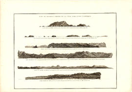
Vue de diverses parties de la côte nord-ouest d'Amérique
Part of City of Vancouver Archives technical and cartographic drawing collection
Item is a graphical plate from an atlas, showing views of Cape Scott, Scott Island, the entrance to Nootka Sound, Woody Point, the entrance to the Columbia River, and Point Barro de Arena. The item is a plate from a French reprinting of "A Voyage of Discovery to the North Pacific Ocean and round the world..." by George Vancouver.
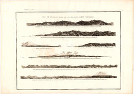
Vue de diverses parties de la côte nord-ouest d'Amérique
Part of City of Vancouver Archives technical and cartographic drawing collection
Item is a graphical plate from an atlas, showing views of Cape Mendocino, Cape Orford, Grenville Point, the entrance to the Straits of Juan de Fuca and the coastline south of Cape Flattery. The item is a plate from a French reprinting of "A Voyage of Discovery to the North Pacific Ocean and round the world..." by George Vancouver.

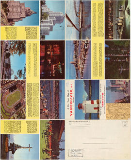
Visitors map of Vancouver ; world famous Stanley Park ; downtown Vancouver
Part of City of Vancouver Archives technical and cartographic drawing collection
Part contains detail maps of Stanley Park and downtown Vancouver, tourist information including traffic rules, locations of churches, golf courses, and amenities, and a list of member businesses of the Vancouver Tourist Association.

Part of City of Vancouver Archives technical and cartographic drawing collection
Part is the front sheet of an unfolded tourism brochure showing Vancouver tourist attractions, The sheet includes a map of downtown Vancouver, with transportation information, a map of the roads in Stanley Park, photographs and information on various sites and attractions in the city, as well as general promotional information.

Part of City of Vancouver Archives technical and cartographic drawing collection
Part is the reverse side of a tourism brochure, containing a tourist map of Greater Vancouver, showing major roads, locations of tourist attractions and recreational sites, and routes into Vancouver.

Part of City of Vancouver Archives technical and cartographic drawing collection
Part contains an illustrated map of Greater Vancouver showing major streets and tourist attractions.

Part of City of Vancouver Archives technical and cartographic drawing collection
Part is one side of a brochure for the Scenery Shop, displaying images , descriptions and prices of various souvenirs available.
Part of City of Vancouver Archives technical and cartographic drawing collection
Part contains promotional images of Vancouver including residences, Stanley Park, English Bay, and Hastings Street.

Victoria, vicinity and Vancouver Island
Part of City of Vancouver Archives technical and cartographic drawing collection
Part is a sheet with three maps: a street map of Victoria, a map of major roads and highways in Greater Victoria, and a highway map of Vancouver Island. The sheet includes street indexes and a mileage chart.

Vest pocket map of Vancouver : map D
Part of City of Vancouver Archives technical and cartographic drawing collection
Part shows Vancouver from Heather Street to Garden Drive and Grant Street to Sixteenth Avenue. Shows district lot and block numbers, public schools, and hospitals.

Vest pocket map of Vancouver : map cover
Part of City of Vancouver Archives technical and cartographic drawing collection

Vest pocket map of Vancouver : map C
Part of City of Vancouver Archives technical and cartographic drawing collection
Part shows Vancouver from Boundary Street (Alma Street) to Heather Street and English Bay/False Creek to Sixteenth Avenue west of Boundary Street (Trafalgar Street) and to Ninth Avenue (Broadway) east of Vine Street. Shows district lot and block numbers, public schools, and hospitals.

Vest pocket map of Vancouver : map B
Part of City of Vancouver Archives technical and cartographic drawing collection
Part shows Vancouver from Westminster Avenue (Main Street) to Garden Drive and Burrard Inlet to Grant Street. Shows district lot and block numbers, public schools, and hospitals.

Vest pocket map of Vancouver : map A
Part of City of Vancouver Archives technical and cartographic drawing collection
Part contains a key plan for the larger maps, textual information about Vancouver, and a map of the West End and downtown Vancouver.

Vancouver, New Westminster, Delta and Surrey : postal area
Part of City of Vancouver Archives technical and cartographic drawing collection
Item is a map which shows the boundaries of postal areas and their corresponding numbers and names.

Part of City of Vancouver Archives technical and cartographic drawing collection
Item is a map of the Lower Mainland from the City of Vancouver east to Port Coquitlam, including the North Shore municipalities, Vancouver, Burnaby, New Westminster, the western portion of Port Coquitlam, Richmond, and the northern portion of Surrey. The pictorial map is in the form of an oblique aerial view oriented to the E/NE.

Vancouver, British Columbia, south-easterly portion, formerly South Vancouver : major street plan
Part of City of Vancouver Archives technical and cartographic drawing collection
Item is a map which has been removed from a copy of the report "A plan for the City of Vancouver, British Columbia, including Point Grey and South Vancouver and a general plan of the region", commissioned by the Vancouver Town Planning Commission from the planning consultants Harland Bartholomew & Associates.
The map shows major streets of sufficient width, major streets to be widened, new major street connections, present street widths, present lines of vehicles, present roadway widths, proposed street widths, proposed lines of vehicles, proposed roadway widths and pleasure drives in the area of the former Municipality of South Vancouver.
Harland Bartholomew and Associates

Vancouver, British Columbia, Canada
Part of City of Vancouver Archives technical and cartographic drawing collection
Part is a pictorial map noting the locations of main tourist sites described on the other side of the sheet. The sheet includes an index of points of special interest.
Bloodgood, Don

Vancouver, British Columbia : south-westerly portion, formerly Point Grey : major street plan
Part of City of Vancouver Archives technical and cartographic drawing collection
Item is a map which has been removed from a copy of the report "A plan for the City of Vancouver, British Columbia, including Point Grey and South Vancouver and a general plan of the region", commissioned by the Vancouver Town Planning Commission from the planning consultants Harland Bartholomew & Associates.
The map shows existing and proposed additions to the major street plan in part of the city that is the former Municipality of Point Grey. The map also shows present street widths, lines of vehicles and roadway widths versus proposed street widths, lines of vehicles and roadway widths.
Harland Bartholomew and Associates

Vancouver, British Columbia : northerly portion, former City of Vancouver : major street plan
Part of City of Vancouver Archives technical and cartographic drawing collection
Item is a map which has been removed from a copy of the report "A plan for the City of Vancouver, British Columbia, including Point Grey and South Vancouver and a general plan of the region", commissioned by the Vancouver Town Planning Commission from the planning consultants Harland Bartholomew & Associates.
The map shows the existing and proposed revisions to the major street plan in the northern portion of Vancouver. The map also shows present street widths, lines of vehicles and roadway widths versus proposed street widths, lines of vehicles and roadway widths.
Harland Bartholomew and Associates

Part of City of Vancouver Archives technical and cartographic drawing collection
Item is a copy of a map of Vancouver which has been hand annotated. The annotations appear to relate to proposed revisions to the street network, including major streets to be widened and new major street connections.
Vancouver (B.C.). Engineer's Office

Part of City of Vancouver Archives technical and cartographic drawing collection
Item is a map showing New Westminster Land District, including lands alienated or covered by application under the Land Act; surveyed timber leases, licences, or berths; Indian reserves; Government reserves; provincial forest boundaries; tree farm licences; municipality boundaries; and park boundaries. Includes a key plan of maps published in the same publisher's series and a reliability diagram noting data sources.
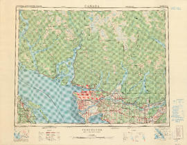
Part of City of Vancouver Archives technical and cartographic drawing collection
Part contains a map of the Greater Vancouver area showing topographic contour lines at 500-foot intervals, roads and road characteristics, railways, parks, towns, reserves, elevations, airports, streams, lakes, and adminstrative boundaries. Includes a key plan of adjoining sheets published in the same series and a small ancillary map showing the declination of the compass needle in 1958.

Part of City of Vancouver Archives technical and cartographic drawing collection
Item is an illustrated tourist map showing parks, major landmarks and major streets in Vancouver and parts of Richmond, Burnaby, West Vancouver and North Vancouver.

Part of City of Vancouver Archives technical and cartographic drawing collection
Item is a topographical map showing lands alienated or covered by application under the Land Act, timber leases, native reserves, government reserves, and various boundaries, as well as campsites, picnic sites, forest service lookouts, post offices, settlements, schools, hospitals, mines, dykes, historic monuments, roads, trails, railways, power lines, phone lines, air harbour or seaplane anchorages, etc. Sheet contains an index map showing adjoining maps in the series.
![Vancouver, B.C., the Pacific coast terminus of the C.P.R. [Canadian Pacific Railway]](/uploads/r/null/8/3/f/83fcf65f0d66d64e6357d0d647e0ea6e2fa4aae4c3d1919f952d7725b4299cda/623e750c-fbab-43b7-a496-d20b384baeb6-LEG1321_142.jpg)
Vancouver, B.C., the Pacific coast terminus of the C.P.R. [Canadian Pacific Railway]
Part of City of Vancouver Archives technical and cartographic drawing collection
Part contains text and engravings describing Vancouver's climate, resources, industries, and buildings. Cover page is stamped "Arthur McMullen."
![Vancouver, B.C., the Pacific coast terminus of the C.P.R. [Canadian Pacific Railway]](/uploads/r/null/e/2/c/e2cdc004f3cf462100ed2ef053aa6087887b3f3200917cd5fba6292afb3b2d2d/bfcde3fa-32d7-4d08-86e5-ecf70c6f8388-LEG1340_142.jpg)
Vancouver, B.C., the Pacific coast terminus of the C.P.R. [Canadian Pacific Railway]
Part of City of Vancouver Archives technical and cartographic drawing collection
Part contains text and engravings describing Vancouver's climate, resources, industries, and buildings.

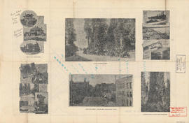
Vancouver, B.C., Pacific terminus of the C.P.R.
Part of City of Vancouver Archives technical and cartographic drawing collection
Part is the front page of an unfoldedd brochure. The text describes Vancouver's growth and prospects for the future. Illustrations of different buildings in Vancouver and some parks are also shown.
Ross and Ceperley (Vancouver, B.C.)

Vancouver, B.C. zoning diagram
Part of City of Vancouver Archives technical and cartographic drawing collection
Part is the front side of an unfolded pamphlet. The sheet contains general information on historical events, why planning is conducted, zoning, general facts about the city and the province, a statement of purpose for town planning, and a list of applicable statutes.

Part of City of Vancouver Archives technical and cartographic drawing collection
Part contains a street map of Greater Vancouver showing highways, municipal boundaries, parks and golf courses.

Part of City of Vancouver Archives technical and cartographic drawing collection
Item is a map showing the location of water pipes and hydrants for the Downtown Eastide and Strathcona west of McLean Drive (D.L. 181, D.L. 182B, D.L. 196). The sheet also includes an inset map of the area bounded by Columbia Street, Alexander Street, Westminster Avenue and Powell Street. Pipes and hydrants are shown in various coloured inks to indicate date of installation.
Vancouver (B.C.). Water Works Department
![Vancouver, B.C. Plan showing location of water pipes, hydrants, etc. [West End]](/uploads/r/null/0/5/05354f71931ba85b05864a2adeb3580a6365ddf962e5084f0bb51c68608364a0/3f57f512-bd27-404e-a332-e0881405c2ac-MAP72_142.jpg)
Vancouver, B.C. Plan showing location of water pipes, hydrants, etc. [West End]
Part of City of Vancouver Archives technical and cartographic drawing collection
Item is a map showing the location of water pipes and hydrants for the West End west of Burrard Street. Pipes and hydrants are shown in various coloured inks to indicate date of installation. Annotations have been added to a base map which is a portion of a larger map.
Vancouver (B.C.). Water Works Department

Part of City of Vancouver Archives technical and cartographic drawing collection
Item is a map showing the location of water pipes and hydrants for the area from Victoria Drive to False Creek to Prince Edward Street to 16th Avenue (D.L. 264A). Pipes and hydrants are shown in various coloured inks to indicate date of installation.
Vancouver (B.C.). Water Works Department
![Vancouver, B.C. Plan showing location of water pipes, hydrants, etc. [South Granville]](/uploads/r/null/e/a/eadb6d7351a77ac5788832abd83754cbe2966049728712aa7773bf6f2a74ff34/819e5ce5-621b-43ff-b1f5-f3bf4cac0562-MAP72_142.jpg)
Vancouver, B.C. Plan showing location of water pipes, hydrants, etc. [South Granville]
Part of City of Vancouver Archives technical and cartographic drawing collection
Item is a map showing the location of water pipes and hydrants in the area between Granville Street and Oak Street, and 11th Avenue and 15th Avenue (D.L. 526). Pipes and hydrants are indicated in red and brown ink.
Vancouver (B.C.). Water Works Department
![Vancouver, B.C. Plan showing location of water pipes, hydrants, etc. [Kitsilano]](/uploads/r/null/0/e/0e33cc4d2f081f551fe6919d35ea37236a6e237a2f5927834d275556995fccfc/0f6ac1ff-8457-41f3-a386-26328c66a4b0-MAP72_142.jpg)
Vancouver, B.C. Plan showing location of water pipes, hydrants, etc. [Kitsilano]
Part of City of Vancouver Archives technical and cartographic drawing collection
Item is a map showing the location of water pipes and hydrants for the area from Spruce Street to False Creek to Vine Street to Tenth Avenue (D.L. 526). Pipes and hydrants are shown in various coloured inks to indicate Installation date. Includes annotations as to whether pipes are wood or steel. Annotations have been added to a base map that is part of a larger map.
Vancouver (B.C.). Water Works Department
![Vancouver, B.C. Plan showing location of water pipes, hydrants, etc. [Hastings Sunrise]](/uploads/r/null/b/c/bc8cb6a6f5ac5df0dd88a65e8a29ecceca242bde2c1b605533ad17eb835cc450/b2741291-73c5-4a98-9f41-db7fdc46fe83-MAP72_142.jpg)
Vancouver, B.C. Plan showing location of water pipes, hydrants, etc. [Hastings Sunrise]
Part of City of Vancouver Archives technical and cartographic drawing collection
Item is a map showing the location of water pipes and hydrants for the area from Kamloops Street to Kootenay Street and Fourteenth Avenue to Government Road (29th Avenue). Pipes and hydrants are indicated in red ink. Base map is a portion of a larger map.
Vancouver (B.C.). Water Works Department
![Vancouver, B.C. Plan showing location of water pipes, hydrants, etc. [Hastings Park area]](/uploads/r/null/0/c/0c5e2bf211ef2e6dfd7a025d620f00d0e64653f3c8080a7e2b3699fffe60e5a3/22c75a7d-7301-4578-8f71-378ca61a6b27-MAP72_142.jpg)
Vancouver, B.C. Plan showing location of water pipes, hydrants, etc. [Hastings Park area]
Part of City of Vancouver Archives technical and cartographic drawing collection
Map is a plan showing the location of water pipes and hydrants in the area between William Street and Burrard Inlet, and Garden Drive and Boundary Road. Pipes and hydrants are indicated in red, with some additional annotations made in black ink. Map includes Hastings Park and the proposed Second Narrows Bridge.
Vancouver (B.C.). Water Works Department
![Vancouver, B.C. Plan showing location of water pipes, hydrants, etc. [Grandview]](/uploads/r/null/8/8/88632d271347b57b818fde723ce9ea599c725a5190b4fb2bbb11e5f98e3809ae/3657fbb2-2cf9-4d03-b885-3836ab221252-MAP72_142.jpg)
Vancouver, B.C. Plan showing location of water pipes, hydrants, etc. [Grandview]
Part of City of Vancouver Archives technical and cartographic drawing collection
Item is a map showing the location of water pipes and hydrants for the years 1905 to 1909 in the area from Graveley Street to 15th Avenue and Victoria Drive to Hastings Townsite (D.L. 264A and D.L. 195). Pipes and hydrants are shown in various coloured inks to indicate date of installation.
Vancouver (B.C.). Water Works Department
![Vancouver, B.C. Plan showing location of water pipes, hydrants, etc. [Fairview slopes]](/uploads/r/null/6/9/69e0d6904facfa2a814069c15122fba46fc4d8077bff76402e95484a4b13d4d8/313b8940-1e98-45d4-b077-abe0f6bee66a-MAP72_142.jpg)
Vancouver, B.C. Plan showing location of water pipes, hydrants, etc. [Fairview slopes]
Part of City of Vancouver Archives technical and cartographic drawing collection
Item is a map showing the location of water pipes and hydrants for the area bounded by Scotia Street, False Creek, Spruce Street and Tenth Avenue (D.L. 526, D.L. 302 and D.L. 200). Block 6 in D.L. 200 was covered by an overlay depicting a later sub-division. Pipes and hydrants are shown in various coloured inks to indicate installation date. Annotations have been drawn on a base map that was part of a larger map.
Vancouver (B.C.). Water Works Department
![Vancouver, B.C. Plan showing location of water pipes, hydrants, etc. [Burrard Street to Gore Avenue]](/uploads/r/null/7/7/7797d041e72dece35da90eab6733a9db50a0b2115ad816578d3633a58bf31761/ebc0f54a-c23a-425c-816d-1dd268a2e4e7-MAP72_142.jpg)
Vancouver, B.C. Plan showing location of water pipes, hydrants, etc. [Burrard Street to Gore Avenue]
Part of City of Vancouver Archives technical and cartographic drawing collection
Item is a map showing the location of water pipes and hydrants for the area Burrard Street to Gore Avenue (D.L. 541). Pipes and hydrants are shown in various coloured inks to indicate installation date.
Vancouver (B.C.). Water Works Department

Part of City of Vancouver Archives technical and cartographic drawing collection

Vancouver, B.C. 1890 : built-on area
Part of City of Vancouver Archives technical and cartographic drawing collection
Item is a map showing downtown Vancouver and a portion of east Vancouver. City blocks, buildings and railway lines are shown. Annotations in pencil mark the location of Granville Bridge, Main Street Bridge, the Vancouver Lumber Company, the Canadian Pacific Railway station, the Hastings Sawmill, False Creek and Burrard Inlet.
Holdsworth, Derek
![[Vancouver, B.C. : district lots]](/uploads/r/null/4/a/4a5c15633319c3754d3aa0cc525470bfebcf5a98ad8caeedf44b777194f300bd/2f055d65-47f7-4679-bb91-66b8f1843d2f-MAP531_142.jpg)
[Vancouver, B.C. : district lots]
Part of City of Vancouver Archives technical and cartographic drawing collection
Item is a map of Vancouver showing established District Lots as of 1913, and Government and Indian reserves.