
- AM54-S13-: LEG1801.085
- Item
- 1859
Part of Major Matthews collection
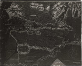
Item is a copy of a portion of a manuscript map of Burrard Inlet, created during the H.M.S. Plumper survey of the area. Sheet shows the eastern portion of the Inlet, including the southern portion of the North Arm.
United Kingdom. Admiralty


![Miscellaneous [60 of 130]](/uploads/r/null/9/e/9ed32a03560d6a3a2c68861822f9fd15db32eb1d7bb2dddb194adba406842fce/583e7e72-0708-4d02-a88a-cd4a1a78ddc4-A64391_142.jpg)
![Mr. Chas Coburn [Copy of survey map of Zeballos]](/uploads/r/null/9/f/d/9fd592159853676e0317c030c447451cc252f4c835e7616d3215f851a12a5e48/95a518bd-678c-473f-abb2-e66b47c90e95-CVA99-7332_142.jpg)
![Sheet 10A [Sydney Street to 22nd Avenue to Knight Street to 28th Avenue]](/uploads/r/null/6/8/a/68a5ee3c33e4a16ab15608383f6f4c59030ccb98434d74a4b9841d8baeb01a4f/797e1ea9-b769-4c53-a498-ddc837d8d6b0-LEG1153_142.jpg)
![Sheet 10B [Slocan Street to 23rd Avenue to Sidney Street to 29th Avenue]](/uploads/r/null/7/a/6/7a643182fb12f452f594aa241aacdb21982fb1e70249d145f3f8edff509857db/bec9da93-10c1-43a2-98ad-4a46771fceb9-LEG1153_142.jpg)
![Sheet 10C [Gladstone Srteet to 29th Avenue to Knight Street to 37th Avenue]](/uploads/r/null/e/e/6/ee677093b334dfa6504db28523f8861a78222a2259d95572fe2ef5131318e857/8a482765-fdbe-4162-9d22-e5bd1c6e3ff2-LEG1153_142.jpg)
![Sheet 10D [Chambers Street to 29th Avenue to Gladstone Street to 37th Avenue]](/uploads/r/null/d/d/7/dd7db9c8c09a85f2d91d18832f6ed2cfe09f88d6850111e170876ccfaec70043/9668563c-4058-4346-ae11-a99c8a48a605-LEG1153_142.jpg)
![Sheet 11A [Victoria Drive to 37th Avenue to Knight Street to 45th Avenue]](/uploads/r/null/6/e/a/6ead9db0025ca23bfc2bcb8dcd095d7cd06a2e60497eb4f6de3c4729d163bf79/b80628c0-b5ff-4789-80b8-4077ef9b593b-LEG1153_142.jpg)
![Sheet 11B [Wales Street to 37th Avenue to Victoria Drive to 45th Street]](/uploads/r/null/1/0/e/10e216d966349146e6c8bcd323ab9c23bd8d76a41fb67e813dc85c3b45d02a85/67f3269b-d839-420f-a865-7504f4573fae-LEG1153_142.jpg)
![Sheet 11C [Victoria Drive to 45th Avenue to Knight Street to 53rd Avenue]](/uploads/r/null/1/d/b/1db11c78e6cbe071c16384954f6cd1c4c7422e511137dfb0d9e475b02429a91e/db8e4f44-94b1-4019-bde7-af2a3bf524f7-LEG1153_142.jpg)
![Sheet 11D [Vivian Street to 45th Avenue to Gladstone Street to 53rd Avenue]](/uploads/r/null/9/6/9/96934c830e4481712138cb8f3cd33681a83ae902562312b7cbd5cd275b1b0da6/bff15411-9432-4e56-b26c-0df02be250e3-LEG1153_142.jpg)
![Sheet 12A [Duff Street to 53rd Avenue to Knight Street to 61st Avenue]](/uploads/r/null/6/2/6/626abd9097f522a3a00f5729e122baf25c1abca24eaebe891f16c22dc206513b/e0ee89cb-6da7-4421-88de-a697d79f3a18-LEG1153_142.jpg)
![Sheet 12B [Vivian Street to 53rd Avenue to Duff Street to 61st Avenue]](/uploads/r/null/e/3/c/e3c8b6efb1d27795c9f95fe0f4f635f96177ec6611aee5c04eb73461e3e81764/b44ecc2f-977b-4819-b58e-558f10cb6378-LEG1153_142.jpg)
![Sheet 12C [Victoria Drive to 61st Avenue to Knight Street to Fraser River]](/uploads/r/null/a/a/4/aa437dca1bb56cbf7a607a6aedce32ae3371be7f3cbfb2e70b74c5e77475af88/6b33c2e7-54fb-44b5-9041-deaad0006465-LEG1153_142.jpg)
![Sheet 12D [Harrison Drive to 61st Avenue to Victoria Drive to SW Marine Drive]](/uploads/r/null/1/0/d/10dafbfa4cf4bf1888a863053dec25b30a177b6441646761b09f6468dee14074/e8338aff-cbd3-4f79-8072-3d661cdd1bd1-LEG1153_142.jpg)
![Sheet 13A [Foot of Victoria Drive to Fraser River]](/uploads/r/null/e/0/7/e076af466f7ca711ddf57dd662031efc3cc4c28e6408b4e31ea3fe7270ab18c7/d6f87673-7469-46e1-a7df-652efb652390-LEG1153_142.jpg)
![Sheet 13B [SW Marine Drive to Duff Street to Fraser River]](/uploads/r/null/0/3/4/03421275306943b3d9eb9b3aaaa73979580d2e415b3a634dee138ceee5ac2b65/e60534ef-16bb-4a15-9951-7bbb070a9b45-LEG1153_142.jpg)
![Sheet 13C [Kinross Street to Kent Avenue to Jellicoe Street to Fraser River]](/uploads/r/null/3/5/2/352b07afbc524c7ddccf37b3e3d97b12d5c0be97fad31325d508b5732250a89b/bbf4f6ac-22ae-415d-9327-d6623a7779a9-LEG1153_142.jpg)
![Sheet 13D [Boundary Road to Ellis Avenue to Kinross Street to Fraser River]](/uploads/r/null/b/2/7/b27058cc4ac42327fbb3aab78b65df9c8b942cbe642a9f79ec83473c1e7ac265/de84ac8c-0385-4ab1-bf1a-3f06a1d433f3-LEG1153_142.jpg)
![Sheet 14A [Hawks Avenue to Burrard Inlet to Main Street to Powell Street]](/uploads/r/null/e/2/8/e288aac0af2470fbe41a5a5898348a18e7de697b091d3e45ec41fa072ec287e6/3bbe6aae-c655-48cd-a519-fc20dc66b684-LEG1153_142.jpg)
![Sheet 14B [Clark Drive to Burrard Inlet to Kawks Avenue to Powell Street]](/uploads/r/null/8/0/7/807b43d4c6da80a78ccf0b257afc77acb7f28fd695221ce80613ebc9f968a0f5/79d752d8-de33-4bad-b374-15b82083bc6f-LEG1153_142.jpg)
![Sheet 15D [Clark Drive to Grandview Highway to Fraser Street to Broadway]](/uploads/r/null/d/0/e/d0e220b834f59ce819f81267f1e4cc2724f031820858ed76bb176c0f78859d08/7e5618ca-ce76-4c90-9c1c-9042a16f0b07-LEG1153_142.jpg)
![Sheet 16A [Fraser Street to Broadway to Main Street to 16th Avenue]](/uploads/r/null/0/c/7/0c74c17cd5eb576019a803e39c6192464bf755b44c7bf8c2af8bc91a4f0c29b2/3b3792a9-4ef2-45a6-a9a6-e8470ab8bc87-LEG1153_142.jpg)
![Sheet 16B [Clark Drive to Broadway to Fraser Street to 16th Avenue]](/uploads/r/null/f/6/4/f64fe8a94788508f9a26125039fd52a10d68c57a6a7955d76b2c90b54cd5bee5/9f5d808d-0e32-404e-9c2d-0cf2ffb68584-LEG1153_142.jpg)
![Sheet 16C [Fraser Street to 16th Avenue to Main Street to 25th Avenue]](/uploads/r/null/1/1/6/1163864e8162291b537da118276007a2b3de69380e8b078eb0d088d795995f87/afb49aec-b5bb-4c60-9401-d4ef89479635-LEG1153_142.jpg)
![Sheet 16D [Knight Street to 16th Avenue to Fraser Street to King Edward Avenue]](/uploads/r/null/5/0/1/5011c29f81b0d7a5d44c56d2ca55bafb60ba5cbf140db322b6645c3c623d3bfe/0fc650fb-612f-43cf-bcf2-f27bcd72fc10-LEG1153_142.jpg)
![Sheet 17A [Fraser Street to 25th Avenue to Main Street to 33rd Avenue]](/uploads/r/null/3/5/e/35efa02285fe97cbbc78720917aa8f41cad1a29600cbbaae19da1739512c2cf6/201df1a8-a4c7-4b71-8d0f-44e0e32ed2a6-LEG1153_142.jpg)
![Sheet 17B [Knight Street to King Edward Avenue to Fraser Street to Durward Avenue]](/uploads/r/null/1/a/f/1aff8dcb09ab65378dfafeb29d7118ccc19705c70cbb15bdad682b0a0909f633/7d7ac22a-48d6-4e8e-8d72-5d4ff3e31715-LEG1153_142.jpg)
![Sheet 17C [Fraser Street to 33rd Avenue to Main Street to 41st Avenue]](/uploads/r/null/5/0/f/50f7c2c32c74cf702ebabbc3345a81811979b51b3074175b7500158f27725381/b5798db5-5cd1-40b1-ba70-17af70186dc8-LEG1153_142.jpg)
![Sheet 17D [Knight Street to Durward Avenue to Fraser Street to 41st Avenue]](/uploads/r/null/6/b/9/6b937fa197e37d6f7b871772b460a37f71b63a0cb6fbbe578e2042c79e665327/9fac95fe-f944-435f-83e7-3a79eac6809b-LEG1153_142.jpg)
![Sheet 18A [Fraser Street to 41st Avenue to Quebec Street to 49th Avenue]](/uploads/r/null/c/8/0/c80a4237c9c4c70aad340c2fb1df174b7ecf854e10b2268e00a49c5535b69999/37febe49-c3ee-4548-9d7d-e61b05fb8c01-LEG1153_142.jpg)
![Sheet 18B [Knight Street to 41st Avenue to Fraser Street to 49th Avenue]](/uploads/r/null/4/6/2/4627396b36381f103746d345ff109e8b8fe827f6171f284cca6c63ff575c8dd6/5d404355-3475-4444-8c85-f4f5fe86c9b3-LEG1153_142.jpg)
![Sheet 18C [Fraser Street to 49th Avenue to Quebec Street to 57th Avenue]](/uploads/r/null/e/2/f/e2f9c3ea4472dbe48bd8516342b20420864c4606305256d7d105ef9c13f8b92d/3f4cc050-5c81-48c0-839f-764a5d3fbc12-LEG1153_142.jpg)
![Sheet 18D [Knight Street to 49th Avenue to Fraser Street to 57th Avenue]](/uploads/r/null/0/8/9/089e18c6a22f42c15094baceb413af7c5bca7847727d97ad9532267883c0b578/858c4aa4-ab11-4eca-8f21-030e40945604-LEG1153_142.jpg)
![Sheet 19A [Fraser Street to 57th Avenue to Main Street to SE Marine Drive]](/uploads/r/null/2/b/5/2b5c2f174f2356fca8e2a0d86b4df5171d325361bd9ec032e6e326729ef84c11/88e414e3-2235-4985-a9d8-68ade9300ff3-LEG1153_142.jpg)
![Sheet 19B [Knight Street to 57th Avenue to Fraser Street to SE Marine Drive]](/uploads/r/null/4/f/5/4f5da15126a4ce02e32ae9838f5a5bdecd4f5a2b191ce8fb6e4c06210812304f/27cf1dda-8922-4f55-a844-84c33a9bcc99-LEG1153_142.jpg)
![Sheet 19C [Fraser Street to SE Marine Drive to Main Street to Fraser River]](/uploads/r/null/f/b/f/fbf3a2bb81c752fc0c5c088ad4b3cec34da9b34f167d22cbe1a942b58136072a/db6db2f9-ab33-4783-aecf-bdcafb0b2647-LEG1153_142.jpg)
![Sheet 19D [Crompton Street to SE Marine Drive to Fraser Street to Fraser River]](/uploads/r/null/b/b/d/bbd20e33657463fa11e84c72e9c22e61a326c74b3e345ca538a418df34a8e50d/ddb0302d-83c7-4fac-9e2f-42d92247806b-LEG1153_142.jpg)
![Sheet 1A [Northwest corner of Exhibition Park to Burrard Inlet to Slocan Street to Cambridge Street]](/uploads/r/null/4/a/9/4a95f2d331599fc1ed353ee49268f50fbc2f377d28b98788199ef496d1657e19/54d2e041-40b4-4c97-89e1-d44e9d73ba03-LEG1153_142.jpg)
![Sheet 1B [Boundary Road to Burrard Inlet to Rupert Street to Cambridge Street]](/uploads/r/null/2/d/e/2de8a9356c43bdf5c2000524f0160e69ebb4155a087c48253380abd411347e98/c0871cff-d576-48da-93e7-50334a7f3bfe-LEG1153_142.jpg)
![Sheet 1C [South portion of Exhibition Park to Cambridge Street to Slocan Street]](/uploads/r/null/0/9/8/098483f307187795ecf4e61450d06083a061d3907b0222ef0f03256008e2e58e/d7a0fcd1-8028-4946-a99a-8ba6da1b2e4a-LEG1153_142.jpg)
![Sheet 1D [Boundary Road to Cambridge Street to Windermere Street to Pender Street]](/uploads/r/null/1/d/4/1d47034f04f443cd5d3bba2f8d2d21c3a21a2e6b801a5af04c074e2c3b6dd02e/7ad1a0c8-97c9-4e10-98c2-5017d74f4033-LEG1153_142.jpg)
![Sheet 20A [Cardero Street to Coal Harbour to Lagoon Drive to Nelson Street]](/uploads/r/null/c/1/5/c15fe5fc7308fea52c7b2dad6a58192b47ebdca216af4850ad394b2e8312a84d/443a9c44-bc78-4001-b61e-78b45cf8eae3-LEG1153_142.jpg)
![Sheet 20B [Burrard Street to Burrard Inlet to Cardero Street to Georgia Street]](/uploads/r/null/2/d/7/2d75e4f8be37129a74a2b029a37894a5c9236512c1cf1e87f396ab643322d50a/6599a0ed-8fbc-49e5-a54c-be3ac20f7ff9-LEG1153_142.jpg)
![Sheet 20C [Cardero Street to Nelson Street to Park Lane to English Bay]](/uploads/r/null/d/f/9/df9674e7f6e9690eb4de6a6352a2f89e4040b0a2b62edd08d8b36edc952d7d0b/e1a5c554-3bb1-46f8-b0d1-77a0c8046fb0-LEG1153_142.jpg)