Surficial geology - Vancouver area
- AM1257-S26-F1-8
- File
- 1956
74 results with digital objects Show results with digital objects
Surficial geology - Vancouver area
Surficial geology - Vancouver area
Part of City of Vancouver Archives technical and cartographic drawing collection
Map is an aerial photograph of the Greater Vancouver area.
The Estate of Joseph Martin, K.C., MP
Part of City of Vancouver Archives technical and cartographic drawing collection
Item is a promotional brochure advertising the sale of lots from the former estate of Joseph Martin, K.C., MP.
The growth of the Greater Vancouver area 1921-1951
The growth of the Greater Vancouver area 1921-1951
The service route to - from - through industrial southwestern British Columbia
Part of City of Vancouver Archives technical and cartographic drawing collection
Item is a pamphlet which shows lines operated by B.C. Hydro and Power Authority including the V & LI Branch of the Canadian Pacific Railway (the BCE Route) in Greater Vancouver. An index map of British Columbia was designed to display on the back page of the pamphlet when folded.
Trans-Canada Highway, Vancouver-Fraser River section

Transit system map of Greater Vancouver, B.C.
Part of City of Vancouver Archives technical and cartographic drawing collection
Part contains a map of Greater Vancouver showing bus lines, route numbers, B.C. Electric installations, block numbers, points of interest and amenities; an inset map showing streets in Gleneagles, Whytecliff, and Horseshoe Bay; and an inset map showing streets in Port Moody, Coquitlam, and Maillardville.

Transit system map of Greater Vancouver, B.C.
Part consists of a map showing trolley coach lines, bus lines, street car lines, interurban lines, interurban stops, route numbers, B.C. Electric installations and block numbers in West Vancouver, North Vancouver, Vancouver, Burnaby and the University Endowment Lands.

Transit system map of Greater Vancouver, B.C.
Part of City of Vancouver Archives technical and cartographic drawing collection
Part contains a map of Greater Vancouver showing bus lines, route numbers, B.C. Electric installations, block numbers, points of interest and amenities; an inset map showing streets in Gleneagles, Whytecliff, and Horseshoe Bay; and an inset map showing streets in Port Moody, Coquitlam, and Maillardville.
Vancouver : spectacular by nature : official courtesy map
Part of City of Vancouver Archives technical and cartographic drawing collection
Primary map on recto shows major roads, hotels, travel apartments, parks, golf courses, gardens, recreational facilities, historical and cultural attractions, shopping centres and other places of interest in the downtown, Stanley Park, Kitsilano and Fairview areas. The map on verso shows similar details for Greater Vancouver (including West Vancouver, North Vancouver, Vancouver, Burnaby, Port Moody, Port Coquitlam, Coquitlam, Pitt Meadows, Maple Ridge, New Westminster, Langley, Surrey, Delta, Richmond and White Rock.
Vancouver and the Lower Mainland
Vancouver and Victoria land use and urban growth
Vancouver and Victoria street and vicinity maps
Part of City of Vancouver Archives technical and cartographic drawing collection
Item is a street map designed to be folded into a pamphlet. Item contains maps of Victoria, Greater Vancouver, and Vancouver Island, a mileage chart, traffic rules, and advertisements.
Vancouver harbour, British Columbia

Part of City of Vancouver Archives technical and cartographic drawing collection
Item is a map showing topography, roads, trails, railways, bridges, boundaries, reserves, power lines, telephone lines, triangulation stations, camera stations, bench marks, houses, barns, mills, factories, schools, churches, post offices, telephone exchanges, mines and geographic features in the area of southern Gambier Island, Bowen Island, Whytecliff, and Caulfeild. A small index map shows the area covered by the primary map in relation to other maps in the series.

Part of City of Vancouver Archives technical and cartographic drawing collection
Item is a map showing topography, roads, trails, railways, bridges, boundaries, reserves, power lines, telephone lines, triangulation stations, camera stations, bench marks, houses, barns, mills, factories, schools, churches, post offices, telephone exchanges, mines and geographic features in the area from Mount Hanover in the north through West Vancouver and North Vancouver, extending south to the northern part of Vancouver. A small index map shows the area covered by the primary map in relation to other maps in the series.
Part of City of Vancouver Archives technical and cartographic drawing collection
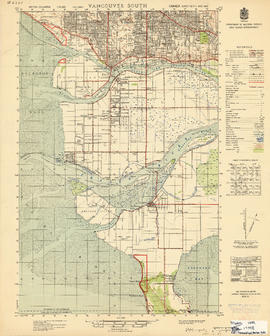
Item is a map showing topography, roads, trails, railways, bridges, boundaries, reserves, power lines, telephone lines, triangulation stations, camera stations, bench marks, houses, barns, mills, factories, schools, churches, post offices, telephone exchanges, mines and geographic features in the area of southern Vancouver and Richmond, extending south to the United States border. A small index map shows the area covered by the primary map in relation to other maps in the series.
Part of City of Vancouver Archives technical and cartographic drawing collection
Map shows major roads, parks, landmarks and tourist attractions in Vancouver and parts of West Vancouver, North Vancouver and Burnaby. The map shows the area from Grouse Mountain in the north to Vancouver International Airport in the south and from Burnaby Lake in the east to Lighthouse Park and the University Endowment Lands in the west
Vancouver, B.C. and vicinity road map
Part of City of Vancouver Archives technical and cartographic drawing collection
Item is a road map of Greater Vancouver and other surrounding areas, created for Standard Oil and distributed by Chevron gasoline stations.
Part of City of Vancouver Archives technical and cartographic drawing collection
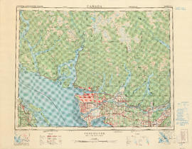
Part contains a map of the Greater Vancouver area showing topographic contour lines at 500-foot intervals, roads and road characteristics, railways, parks, towns, reserves, elevations, airports, streams, lakes, and adminstrative boundaries. Includes a key plan of adjoining sheets published in the same series and a small ancillary map showing the declination of the compass needle in 1958.

Part of City of Vancouver Archives technical and cartographic drawing collection
Item is an illustrated tourist map showing parks, major landmarks and major streets in Vancouver and parts of Richmond, Burnaby, West Vancouver and North Vancouver.
Part of City of Vancouver Archives technical and cartographic drawing collection
Item is a tourism brochure with a map on one side and tourism information on the reverse.

Part of City of Vancouver Archives technical and cartographic drawing collection
Item is a topographical map showing lands alienated or covered by application under the Land Act, timber leases, native reserves, government reserves, and various boundaries, as well as campsites, picnic sites, forest service lookouts, post offices, settlements, schools, hospitals, mines, dykes, historic monuments, roads, trails, railways, power lines, phone lines, air harbour or seaplane anchorages, etc. Sheet contains an index map showing adjoining maps in the series.
Part of City of Vancouver Archives technical and cartographic drawing collection
Item is a topographic map of the Greater Vancouver area showing a number of built and natural features. Includes a key plan of adjoining sheets published in the same series, a small ancillary map showing the declination of the compass needle in 1958, and a key of signs and symbols in English and French.
Vancouver, British Columbia : Daytime population distribution, 1961 generalized
Vancouver, British Columbia : distribution of young children and adults, 1961
Vancouver, British Columbia : population distribution, 1961
Vancouver, British Columbia : Population distribution, 1961 generalized
Vancouver, British Columbia : port facilities
Vancouver, British Columbia : [urban analysis maps]
Part of City of Vancouver Archives technical and cartographic drawing collection
Maps show land use, land slope and elevation, density of buildings, structural material of buildings, height of buildings, water supply systems, sewage systems, electric power systems, gas trunk systems, population distribution, daytime population distribution, dwelling units, schools, hospitals and doctors, land transportation, port facilities, food manufacturing, textile manufacturing, wood product manufacturing, metal product manufacturing, transportation equipment manufacturing, non-metallic mineral and chemical products manufacturing, retail and wholesale food enterprises, retail and wholesale building materials enterprises, retail and wholesale drugs, general merchandise, apparel and accessories enterprises, retail and wholesale clothing and shoes enterprises, retail and wholesale furnishing enterprises and hotels and eating places in the Greater Vancouver area (including West Vancouver, North Vancouver, Vancouver, Burnaby, New Westminster, the northern portion of Richmond and the western portion of Coquitlam). Much of the data for these maps was derived from the 1961 census of Canada.
Vancouver, British Columbia, land transportation

Part of City of Vancouver Archives technical and cartographic drawing collection
Item is a map of the Lower Mainland from the City of Vancouver east to Port Coquitlam, including the North Shore municipalities, Vancouver, Burnaby, New Westminster, the western portion of Port Coquitlam, Richmond, and the northern portion of Surrey. The pictorial map is in the form of an oblique aerial view oriented to the E/NE.

Vancouver, New Westminster, Delta and Surrey : postal area
Part of City of Vancouver Archives technical and cartographic drawing collection
Item is a map which shows the boundaries of postal areas and their corresponding numbers and names.
![Vancouver's high-tech industry location map plus G.V.R.D. [Greater Vancouver Regional District] d...](/uploads/r/null/2/b/7/2b7c912f51dd7827d1a0ac60042357a631d2c8fdc3487bc37f286d2945c4ea4c/7a17e6a4-d593-45c5-9625-f03c471efb68-LEG1362_142.jpg)
Part of City of Vancouver fonds
Item is a map annotated to show locations of Vancouver technology firms. Categories of activity are system design/consulting, fabrication/manufacturing, design/fabrication, research/development, and other. Base map is a street map produced by the Engineering Department.
Victoria and Vancouver street and vicinity maps
Part of City of Vancouver Archives technical and cartographic drawing collection
Item is a map sheet with street and other maps of Greater Vancouver, Greater Victoria, and highways maps of the surrounding areas.
Visit the Scenery Shop, souvenir headquarters
Part of City of Vancouver Archives technical and cartographic drawing collection
Item is a promotional brochure for The Scenery Shop, a retailer of souvenirs located at 656 Granville Street. One side of the brochure when unfolded displays a map designed by the shop's proprietor, William L. Webber, showing points of interest and an inset map showing the location of the shop. The other side of the unfolded sheet shows photographs and lists of products available in the shop.
Part of City of Vancouver Archives technical and cartographic drawing collection
Item is a map and tourist guide to Vancouver showing major roadways and tourist attractions in the Greater Vancouver area on one side, and Stanley Park, downtown Vancouver, and textual tourist information on the other.
Visitors map. Southwestern British Columbia & Greater Vancouver, Canada
Part of City of Vancouver Archives technical and cartographic drawing collection
Item is a tourist brochure which includes maps, illustrations and text providing information on tourist sites and municipalities in the Greater Vancouver Regional District.

Item is a map of Greater Vancouver showing streets, parks, schools and hospitals; includes street index.
Part of City of Vancouver Archives technical and cartographic drawing collection
Item is a two-sided road map containing a map of Saskatchewan, Manitoba and the adjoining U.S. states; a map showing Canada and the United States from Labrador and Prince Rupert, B.C. in the north to Richmond, Virginia and San Francisco, California in the south; a map of British Columbia and Alberta; and an illustrated map of Greater Vancouver. The item includes road indexes, a mileage chart for Western Canada, and information on national parks in Western Canada.
Wrigley's 1930 map of Vancouver and Lower Mainland
Part of City of Vancouver Archives technical and cartographic drawing collection
Item is a map of Greater Vancouver with a street index on verso. Map shows streets, paved streets, trails, street car lines, bus lines, railways, auto camps, hospitals, schools and block numbers. Concentric circles spaced one mile apart emanate from a point in downtown Vancouver.

Wrigley's new map of Vancouver and Lower Mainland
Part of City of Vancouver Archives technical and cartographic drawing collection
Part contains a map showing streets and block numbers in Vancouver, West Vancouver, North Vancouver, Burnaby, New Westminster and the northern part of Richmond.
Wrigley's new revised map of Vancouver
Item is a street map of Vancouver, with a street index on the verso.