
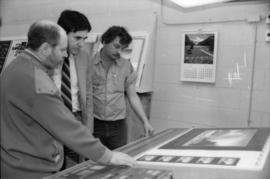
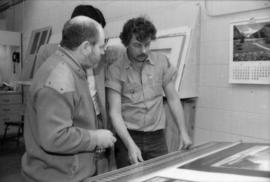
Toni Onley (left) and group examine Centennial Art Series print at Agency Press
- AM1576-S6-12-: 2011-010.2729-: 2011-010.2729.27
- Part
- May 1985
9943 results with digital objects Show results with digital objects
Toni Onley (left) and group examine Centennial Art Series print at Agency Press
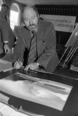
Toni Onley signing Centennial print


Toni Onley, unidentified woman and Robert Dubberley hold up Centennial Art Series print
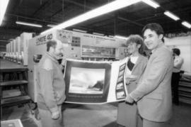
Toni Onley, unidentified woman and Robert Dubberley hold up Centennial Art Series print

Part of City of Vancouver Archives technical and cartographic drawing collection
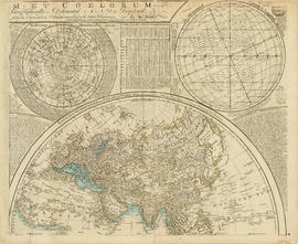
Part depicts the upper left hand quadrant of the map, and includes a diagram of the solar system, a table of dimensions of bodies in the solar system, a chart of constellations viewable in the northern hemisphere, text on geographical definiations and the cause of the tides, and a map of the northern half of the Americas.
Dunn, Samuel
Part of City of Vancouver Archives technical and cartographic drawing collection
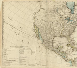
Part is the top left hand quadrant of a map of the Americas, and depicts North America and the north-west portion of South America. The sheet also includes a list of territories and islands in North America and appears to relate to territorial divisions as a result of the Treaty of Paris and the Treaty of Versailles (1783).
Part of City of Vancouver Archives technical and cartographic drawing collection
Part depicts a chart of the astronomical latitude & longitude analemma, a table showing values of the place of the sun in the ecliptic & declinatiobn, a chart of the constellations viewable in the southern hemisphere, text on geographical definitions and the cause of the tides, and a map of the northern portion of Africa, Europe and Asia.
Dunn, Samuel
Part of City of Vancouver Archives technical and cartographic drawing collection
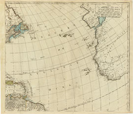
Part is the top right portion of a map of the Americas, and depicts the north-eastern portion of the Canadian coast, the eastern portion of the West Indies, the north-east corner of South America and the coastal areas of south-west Europe and wesern Africa.

Tourism Canada Celebrates float

Tourism Canada Celebrates float

Tourist map of Greater Vancouver
Part of City of Vancouver Archives technical and cartographic drawing collection
Part is a sheet with two maps. The main map shows a pictorial view of Greater Vancouver, including the location of major roads and tourist attractions. Drawings of "the most important single objects on totem poles of the Pacific Northwest Indians" form a decorative border. The inset map shows downtown Granville Street and the location of the Scenery Shop.

Tourists' map of Greater Vancouver : cover
Part contains the front and back covers of the pamphlet, a map of Downtown Vancouver, a map of the downtown section of New Westminster, and information for tourists, including interesting facts about Vancouver. Maps show principal street names and some building names.

Tourists' map of Greater Vancouver : inside cover
Part consists of the inside cover of pamphlet containing information about David Spencer Limited.

Tourists' map of Greater Vancouver : map of downtown Vancouver and map of New Westminster
Part contains a map of Downtown Vancouver, a map of the downtown section of New Westminster, and information for tourists including interesting facts about Vancouver. Maps show principal street names and some building names.

Part consists of a map of Greater Vancouver. Map extends from Howe Sound to Dome Mountain to Pitt River to Lulu Island. Map shows principal street names, golf and country clubs, bodies of water and city limits. Part contains textual information about parking regulations for the David Spencer store.

T.R. Fyfe passing gavel to the new P.N.E. president, H.W. Mullholland at P.N.E. meeting


Transit detail inset maps ; Street index ; Transit and tourist information
Part consists of three maps showing transit details in Richmond, New Westminster and downtown Vancouver, and descriptive information about B.C. Electric routes and services and Greater Vancouver attractions.
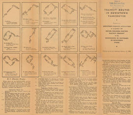
Transit routes in downtown Vancouver : side 1
Part contains illustrations of the downtown Vancouver portions of the B.C. Electric transit routes and text descriptions of all B.C. Electric transit routes in Vancouver, New Westminster, North Vancouver, Richmond, and Burnaby effective up to and including February 15, 1950.

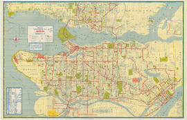
Transit routes in downtown Vancouver : side 2
Part contains a continuation of text descriptions of transit routes from side 1. Part also contains a map showing B.C. Electric transit routing in downtown Vancouver. Map includes street names and a legend of routes and stops.
Transit system map of Greater Vancouver
Part of City of Vancouver Archives technical and cartographic drawing collection
Part is a map showing the routes of various BC Electric transit services. The inset map shows the Forest Hills/Canyon Heights area. The map also includes a guide to Vancouver street numbers.