![[10th Avenue and Cambie Street, site of City Hall]](/uploads/r/null/6/4/6418f3fc5601a83ba3ed95785e1b2578594011e277644210623a99b5dc54714c/5c2e9b9f-71b2-4409-b81f-3d7e89f81135-A09176_142.jpg)
[10th Avenue and Cambie Street, site of City Hall]
- AM54-S4-: City N29.2
- Item
- 13 Sept. 1934
Part of Major Matthews collection
Photograph shows the location of the current City Hall prior to construction.
[10th Avenue and Cambie Street, site of City Hall]
Part of Major Matthews collection
Photograph shows the location of the current City Hall prior to construction.
![[10th Avenue and Cambie Street, site of City Hall]](/uploads/r/null/a/e/aee0e0d4ade7c27b4e5b9c837fa6402a1c06163f87f6fc8557534c7d50366695/c4271149-4157-44ae-a17d-5eb69fcfda69-A09175_142.jpg)
[10th Avenue and Cambie Street, site of City Hall]
Part of Major Matthews collection
Photograph shows the location of the current City Hall prior to construction.
Part of City of Vancouver fonds
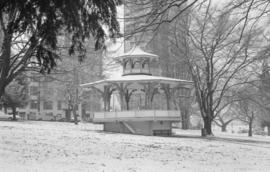
Item is a photograph showing the Alexandra Bandstand.

Part of City of Vancouver fonds
Item is a photograph showing the Alexandra Bandstand.

Part of City of Vancouver fonds
Item is a photograph showing the Alexandra Bandstand.
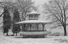
Part of City of Vancouver fonds
Item is a photograph showing the Alexandra Bandstand.
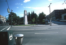
200 West Hastings Street south side
Part of City of Vancouver fonds
Image shows Victory Square from the north side, the cenotaph, and a shaded view up Hamilton Street.
200 West Pender Street north side
Part of City of Vancouver fonds
Image shows the south side of Victory Square Park.
200 West Pender Street north side
Part of City of Vancouver fonds
Image shows the south side of Victory Square Park.

200 West Pender Street north side
Part of City of Vancouver fonds
Image shows the south side of Victory Square Park.

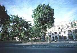
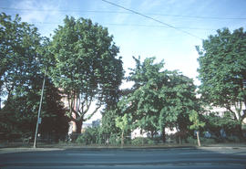
Part of City of Vancouver fonds
Image shows the trees on the west side of Victory Square and on the left, a small portion of the Vancouver Vocational Institute with "silver anniversary banner".

Part of City of Vancouver fonds
Images primarily shows the trees on the west side of Victory Square.

Part of City of Vancouver fonds
Image shows primarily the trees on the west side of Victory Square.

Part of City of Vancouver fonds
Image shows a view along Hastings Street (including the Woodwards Building) and the west side of Victory Square.
![[A baseball game at Recreation Park at Smithe Street and Homer Street]](/uploads/r/null/3/b/3bdbc7fce9633069d75ecf2828ef2d9514ddced9c50ee746e9b9f5f130f59530/b60c68a4-98fb-4191-a6dd-437754fde175-A71017_142.jpg)
[A baseball game at Recreation Park at Smithe Street and Homer Street]
Part of Major Matthews collection
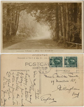
A driveway in Stanley Park, Vancouver BC
This postcard includes personal correspondence. Sent to Mrs. E. Milton Small of Gillingham, Kent, England, from her son Harry in Vancouver.

A misty morning, Stanley Park, Vancouver, B.C.
This postcard includes personal correspondence. Sent to Mrs. E. Milton Small of Gillingham, Kent, England, from her son Harry in Vancouver.
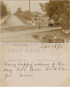
Item is a postcard printed with an image of a residential street in the neighborhood of English Bay. The image also shows automobiles driving by a corner of a park in which people are sitting.

Part of Charles F. Smith fonds
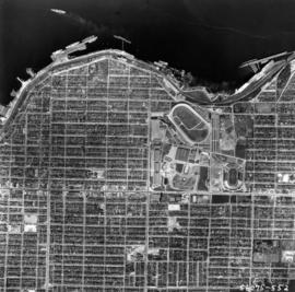
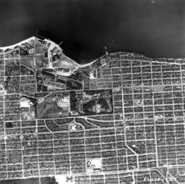
Aerial photo, vertical, Exhibition Park and surrounding area
Item is a photograph of Exhibition Park and the surrounding area, looking north. The area photographed runs from Vancouver Harbour to Charles Street, and from Lakewood Drive to Skeena Street.

Aerial photo, vertical, Exhibition Park, Vancouver
Aerial photo, vertical, Jericho Beach Park and Kitsilano
Item is a photograph of Jericho Beach Park and the surrounding area, looking north. The area photographed runs from English Bay and Jericho Beach to W 16th Avenue,and from Sasamat Street to Balaclava Street.

Aerial photo, vertical, Little Mountain and Oakridge and surrounding area
Item is a photograph of Little Mountain and Oakridge, showing from W 30th Avenue to W 54th Avenue, and from Hudson Street to Main Street. Includes the Langara golf course and Queen Elizabeth Park.
![[Aerial survey view of First Narrows, Stanley Park, the West End, Downtown and North Vancouver]](/uploads/r/null/f/8/f875c0a639388b4936ef86faafb227a0fcad6478409cc8c2ff64fa2c06296ca5/94a6f99f-1ce3-4c9b-9e48-894735d096e9-A23486_142.jpg)
[Aerial survey view of First Narrows, Stanley Park, the West End, Downtown and North Vancouver]
Part of Major Matthews collection
Perpendicular view (mosaic)
![[Aerial view looking east over Stanley Park, Coal Harbour and Burrard Inlet]](/uploads/r/null/d/0/d02fee694c486ac2accdeefb505d0dae5fcb42789ef16de49322d845e3c04b44/be8c34ce-7c09-4c0e-a395-f083c9134080-A43248_142.jpg)
[Aerial view looking east over Stanley Park, Coal Harbour and Burrard Inlet]
Part of Major Matthews collection
Oblique view
![[Aerial view of Burrard Inlet, Hastings-Sunrise, Burnaby and the District of North Vancouver]](/uploads/r/null/d/f/df7e11c97173ce0473c454f0a01569b641972f6efdc12bf192edbc42119542d6/6d72f89b-9b55-48c4-bef6-04eb2137f1d3-A66600_142.jpg)
[Aerial view of Burrard Inlet, Hastings-Sunrise, Burnaby and the District of North Vancouver]
Part of Major Matthews collection
Photograph shows Exhibition Park and P.N.E. Golf Course, Second Narrows Bridge, New Brighton Park, Callister Park, Burrard Inlet, Lynn Creek, Lynn Park, Seymour Creek, Vancouver Harbour Commissioners Railway, Inspected Shingles Ltd., Cascade Rock and Gravel Co. Ltd., Canadian Shingle Co. Ltd. (Capilano Timber Co. Ltd.), Alberta Pool Elevator, Columbia Grain Elevator Co. Ltd., Canadian Pacific Railway, Girls Industrial School and Old Peoples Home sites.
![[Aerial view of Mount Pleasant, South Strathcona and Kensington-Cedar Cottage]](/uploads/r/null/7/5/75ea991fe8319eaffda79b314cbf20e281e35eb2cd8a89eaa898b492242d6282/05f856f3-0a45-41eb-94dc-46cb9d2f7ecf-A63348_142.jpg)
[Aerial view of Mount Pleasant, South Strathcona and Kensington-Cedar Cottage]
Part of Major Matthews collection
Photograph shows aerial view of the east end of False Creek, Thornton Park, Great Northern Railway and Canadian National Railway yards, Mount Pleasant, Strathcona, Grandview-Woodland, Trout Lake, Kingsway, Vancouver Technical School grounds, Renfrew playing fields, John Hendry Park, British Columbia Electric Railway Right of Way, Clark Park, Grandview Highway South, Great Northern Railway.

Aerial view of New Brighton Park site, looking east from Renfrew Street
Part of Wilson family fonds
Image shows grain elevators and Canadian Pacific Rails.

Aerial view of New Brighton Park site, looking west along waterfront toward foot of Renfrew Street
Part of Wilson family fonds
![[Aerial view of the West End showing the increase of apartment buildings west of Cardero Street]](/uploads/r/null/9/4/9410444a29ad3e6e13228ba5ad44b40986af7ad70945337641000d03b991a529/ee9fb9e8-21b9-4ca5-a5b6-d28e6d51046e-A25977_142.jpg)
[Aerial view of the West End showing the increase of apartment buildings west of Cardero Street]
Part of Major Matthews collection
Photograph shows oblique view of Lost Lagoon, Stanley Park and Lord Roberts School
![[Aerial view of Vancouver]](/uploads/r/null/b/9/b973b9a4143a5316b02e728c35d99e383f27a3db21d8e20aa7bbb459780243bc/3ff38b56-6b36-4c17-bce1-329c97459d29-A66598_142.jpg)
Part of Major Matthews collection
Photograph shows Kitsilano, Kits Point, Kitsilano Beach, R.C.A.F. Equipment Depot, Kitsilano Pool, Burrard Bridge, C.P.R. Kitsilano Trestle, Granville Island, Granville Bridge, Cambie Bridge, False Creek, C.P.R. False Creek Yards, West End, Yaletown, Arbutus Ridge, Shaughnessy, South Cambie, Fairview, Mount Pleasant, Little Mountain Reservoir, Connaught Park, Quilchena Golf Course, Douglas Park, Shaughnessy Heights Golf Course, Queen Elizabeth Park, Royal Canadian Mounted Police Barracks, Shaughnessy Military Hospital, Hillcrest Park, Robertson & Hacket Sawmill, City Yard, West Coast Ship Builders and Athletic Park.
![[Aerial view of Vancouver Harbour from Stanley Park looking east to Indian Arm]](/uploads/r/null/c/b/cb066fdc626d69001bfb4c896937f586737298cc09ee0de3cc7fdd0bca8df09e/93414b9d-edd5-4e76-a79d-fb7a26360472-A31831_142.jpg)
[Aerial view of Vancouver Harbour from Stanley Park looking east to Indian Arm]
Part of Major Matthews collection
Oblique view
![[Aerial view of West Point Grey, Kitsilano, Dunbar - Southlands and University Endowment Lands]](/uploads/r/null/0/8/089d213e9a81ca689130a244122a86972e068c9b01ab994922a88072ac881121/1ed71859-c157-4686-82db-e3483cd4b877-A66599_142.jpg)
[Aerial view of West Point Grey, Kitsilano, Dunbar - Southlands and University Endowment Lands]
Part of Major Matthews collection
Photograph shows the south Slope of English Bay, Spanish Banks, Locarno Beach Park, Jericho Beach, R.C.A.F. Jericho Air Station, Kitsilano pool, Connaught Park and Kitsilano Beach Park, Caldecott Park, Quilchena Golf Course, School for Deaf and Blind and Quesnel Park.
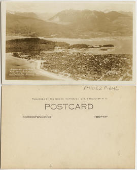
Aeroplane view of the North Shore - Stanley Park - West End and English Bay - Vancouver B.C.
![[Alexandra Park]](/uploads/r/null/a/a/aa5a43bde770806111c0ea2763e09c8c4c0f2e7d7f83b4c4e6390acf8746b454/a68477f1-afa8-422b-940e-99edad20867e-A59294_142.jpg)
Part of City of Vancouver fonds

Alexandra Park - Joe Fortes Memorial drinking fountain, back
Part of City of Vancouver fonds

Alexandra Park - Joe Fortes Memorial drinking fountain, front (bandstand behind)
Part of City of Vancouver fonds
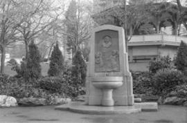
Alexandra Park - Joe Fortes Memorial drinking fountain, front (bandstand behind)
Part of City of Vancouver fonds

Alexandra Park - Red Oak (Cardero Street and Beach Avenue)
Part of City of Vancouver fonds

Item is a photograph of the bandstand at Alexandra Park, English Bay. Two small children walk on the grass near the bandstand and the English Bay Pier can be seen in the lower left background.
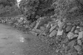
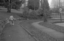
Almond Park dry rock wall and cut granite steps
Part of City of Vancouver fonds
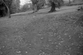
Almond Park path on bank (not well articulated)
Part of City of Vancouver fonds
Part of City of Vancouver fonds
Part of City of Vancouver fonds

Almond Park, looking west - Copper Beach
Part of City of Vancouver fonds
Almond Park, West 13th Avenue, street end
Part of City of Vancouver fonds

Part of City of Vancouver fonds

Part of City of Vancouver fonds

Part of City of Vancouver Archives sound recording and moving image collection
Item is a film containing home movie footage filmed by Allan Crocker. The film shows Stanley Park including the Stanley Park zoo, birds and the Dining Pavilion; Coal Harbour; the Lion's Gate Bridge; Queen Elizabeth Park; a trip to [Caribou?]; an airport; and Christmas celebrations at the Crocker residence, 7347 West Boulevard.

Bandstand in Alexandra Park, English Bay
Part of Art Grice fonds