
Bus routings in the downtown area
- AM738-S1-: MAP 894-: LEG1256.2
- Part
- 1956
Part contains textual information about bus routes and services.
Bus routings in the downtown area
Part contains textual information about bus routes and services.
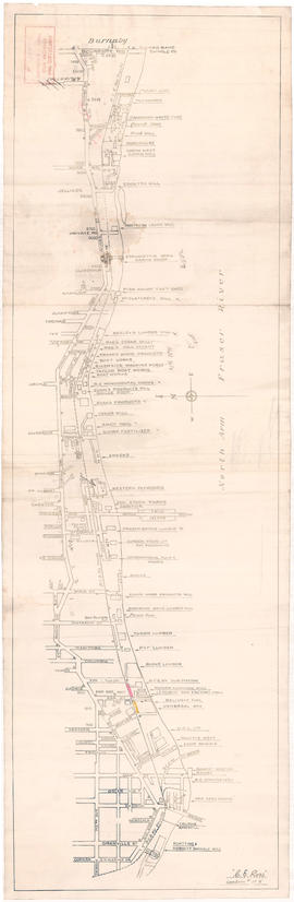
Businesses along the north shore of the North Arm of the Fraser River
Item is a map showing the locations and names of businesses located along the north shore of the North Arm of the Fraser River.
Ross, C.E.

Item is a copy of a City of Vancouver Engineering Department map showing streets, railways, parks and golf courses. Indicates dedicated and undedicated streets open to traffic, streets open to restricted traffic only, and private roads.
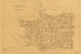
City of Vancouver, British Columbia

Composite map of B.C. Electric downtown bus routes
Part shows bus routes from Burrard Inlet in the north to False Creek in the south and from Main Street in the east to Thurlow in the west.

Part contains a street map of Vancouver showing streets, block numbers, bus routes, railway lines, boundaries, private roads and hospitals. The map includes a dial (a numbered circle, a paper indicator, a grid of block numbers and a street index used to find locations in Vancouver). A small inset shows the streets surrounding Queen Elizabeth Park, which are obscured on the main map where the indicator is attached.

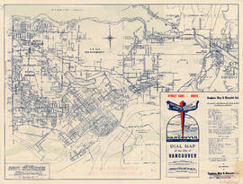
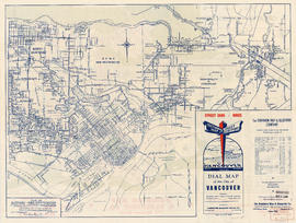
Item is a street map of Vancouver showing block numbers, bus routes, railway lines, boundaries, private roads and hospitals in Vancouver. Map includes the printed portion of the dial (a numbered circle, a grid of block numbers and a street index used to find locations in Vancouver), but no indicator is attached. A small inset map shows the streets surrounding Queen Elizabeth Park.
Item is a map showing street car lines, bus lines, block numbers, railway lines, boundaries and hospitals in Vancouver. The map includes the printed portion of the dial (a numbered circle, a grid of block numbers and a street index used to find locations in Vancouver), but no indicator is attached.

Part contains a street map of Vancouver showing streets, block numbers, bus routes, railway lines, boundaries, private roads and hospitals. The map includes a dial (a numbered circle, a paper indicator, a grid of block numbers and a street index used to find locations in Vancouver). A small inset map shows the streets surrounding Queen Elizabeth Park, which are obscured on the main map where the indicator is attached.

Item is a map showing street car lines, bus lines, block numbers, railway lines, boundaries and hospitals in Vancouver. The map includes the printed portion of the dial (a numbered circle, a grid of block numbers and a street index used to find locations in Vancouver), but no indicator is attached.

Part consists of a street map of Vancouver showing block numbers, street car, bus, and railway lines, parks and hospitals. Map includes a dial (a numbered circle, a paper indicator, a grid of block numbers and a street index used to find locations).

Part contains a street map of Vancouver showing streets, block numbers, bus routes, railway lines, boundaries, private roads and hospitals. The map includes a dial (a numbered circle, a paper indicator, a grid of block numbers and a street index used to find locations in Vancouver). A small inset map shows the streets surrounding Queen Elizabeth Park, which are obscured on the main map where the indicator is attached.

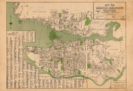
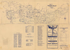
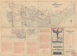
Dial map of Greater Vancouver and suburbs
Part contains a street map of Vancouver, West Vancouver, North Vancouver, and Burnaby showing railways, hospitals, parks and block numbers. The map includes the printed portion of the dial (a numbered circle, a grid of block numbers and a street index used to find locations), but no indicator is attached. Two small insets show the streets of Gleneagles in West Vancouver and Norgate Park in North Vancouver.

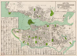
Dial map of Greater Vancouver and suburbs
Part contains a street map of Vancouver, West Vancouver, North Vancouver and Burnaby showing streets, block numbers, bus routes, railway lines, boundaries, private roads and hospitals. The map includes a dial (a numbered circle, a paper indicator, a grid of block numbers and a street index used to find locations).

Dial map of Greater Vancouver and suburbs
Part contains a street map of Vancouver, West Vancouver, North Vancouver, and Burnaby showing railways, hospitals, parks and block numbers. The map includes the printed portion of the dial (a numbered circle, a grid of block numbers and a street index used to find locations), but no indicator is attached. A small inset shows the streets of Gleneagles in West Vancouver.
Dial map of Greater Vancouver and suburbs
Part contains a street map of Vancouver, West Vancouver, North Vancouver and Burnaby showing streets, block numbers, bus routes, railway lines, boundaries, private roads and hospitals. The map includes the printed portion of the dial (a numbered circle, a grid of block numbers and a street index used to find locations), but no indicator is attached.

Dial map of Greater Vancouver and suburbs
Part contains a street map of Vancouver, Burnaby, New Westminster, West Vancouver, and North Vancouver showing railways, hospitals, parks and block numbers. The map includes two dials (numbered circles, paper indicators, a grid of block numbers and a street index used to find locations).
Dial map of Greater Vancouver and suburbs
Part contains a street map of Vancouver, West Vancouver, North Vancouver, and Burnaby. Map includes the printed portion of the dial (a numbered circle, a grid of block numbers and a street index used to find locations), but no indicator is attached.
Dial map of Greater Vancouver and suburbs
Part contains a street map of Vancouver, West Vancouver, North Vancouver, and Burnaby showing railways, hospitals, parks and block numbers. The map includes a dial (a numbered circle, a paper indicator, a grid of block numbers and a street index used to find locations). A small inset shows the streets of Gleneagles Park in West Vancouver.
Dial map of Vancouver and suburbs
Part consists of a street map of Vancouver, West Vancouver, North Vancouver, and Burnaby. Part includes the printed portion of the dial (a numbered circle, a grid of block numbers and a street index used to find locations), but no indicator is attached.

False Creek development survey occupation plan
Item is a copy of a City of Vancouver Engineer's Office map of the False Creek area from Walnut Street to Main Street and downtown to Sixth Avenue. Map shows streets, railway lines, names of businesses occupying sites on the waterfront, and former high tide waterlines.

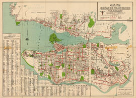
Map shows boundaries, lot numbers and major roads in Greater Vancouver (including West Vancouver, North Vancouver, the City of North Vancouver, the City of Vancouver, Coquitlam, Point Grey, South Vancouver, Burnaby, New Westminster, Port Moody, Port Coquitlam, Pitt Meadows, Surrey, Langley, Delta and Richmond).

Part is a page of promotional and descriptive information about Vancouver, the Hotel Grosvenor and Douglas Lodge. The page includes a map showing the location of Douglas Lodge on Stuart Lake, near Fort St. James, B.C.

Information on transit and buildings in Vancouver
Part is the text side of a street map of Vancouver. Part also includes text advertisitng the products and services of the Dominion Map and Blueprint Company.

Map of Burnaby and New Westminster, British Columbia
Part consists of a street map of Burnaby and New Westminster, information on bus and street car routes, and text advertising the products and services of the Dominion Map and Blueprint Company.
Map of Burnaby, New Westminster and parts of adjacent municipalities
Part consists of a street map of Burnaby, New Westminster, Coquitlam, and parts of Port Moody and Port Coquitlam, as well as text advertising the products and services of the Dominion Map and Blueprint Company.
Map of Burnaby, New Westminster and parts of adjacent municipalities
Part consists of a street map of Burnaby, New Westminster, Coquitlam, and parts of Port Moody and Port Coquitlam, as well as text advertising the products and services of the Dominion Map and Blueprint Company.

Map of Burnaby, New Westminster and parts of adjacent municipalities
Part consists of a street map of Burnaby, New Westminster, Coquitlam, and parts of Port Moody and Port Coquitlam, as well as text advertising the products and services of the Dominion Map and Blueprint Company.

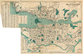
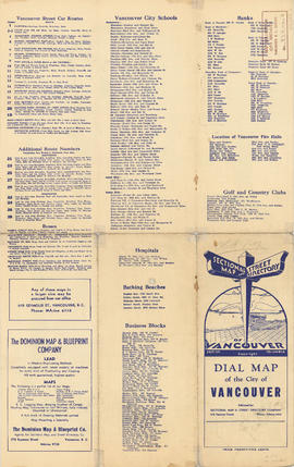
Map of City of Vancouver, British Columbia
Map shows streets, schools, hospitals, street car lines, railways and address block numbers in Vancouver.

Part consists of a street map of the Lower Mainland and Fraser Valley from Vancouver to Chilliwack, a street map of New Westminster, a map of Vancouver and North Vancouver showing street names but not street lines, and text advertising the products and services of the Dominion Map and Blueprint Company.

Item is a map of the Fraser Valley from Vancouver to Chilliwack showing roads, railway lines, schools, churches, and post offices.
Part consists of a map showing the Lower Mainland from Vancouver to Chilliwack, including major roadways, rail and bus lines, and a smaller street map of New Westminster. Part includes information on bus and street car lines in Vancouver, West Vancouver, North Vancouver, and Burnaby, as well as text advertising the products and services of the Dominion Map and Blueprint Company.
Part consists of a map showing major roadways in the Lower Mainland and the Fraser Valley from Vancouver to Chilliwack, and lists of Vancouver businesses, schools, public buildings, hospitals, bathing beaches, fire halls, and golf and country clubs. Part includes text advertising the products and services of the Dominion Map and Blueprint Company.
Part consists of a map showing the Lower Mainland from Vancouver to Chilliwack, including major roadways, rail and bus lines, and a smaller street map of New Westminster. Part includes information on bus and street car lines in Vancouver, West Vancouver, North Vancouver, and Burnaby, as well as text advertising the products and services of the Dominion Map and Blueprint Company.

Map of Fraser Valley ; Map of City of New Westminster ; Street map of Richmond, Delta, and Surrey
Part consists of a street map of the Fraser Valley from Surrey to Mission, a street map of New Westminster, and a street map of Richmond, Delta, and Surrey. Part also contains text advertising the products and services of Dominion Map and Blueprint Ltd.

Map of Fraser Valley ; Map of municipality of Richmond ; Map of City of New Westminster
Part consists of a map of the Lower Mainland from Vancouver to Chilliwack, a street map of Richmond, and a street map of New Westminster. Part also contains text advertising the products and services of Dominion Map and Blueprint Ltd.

Map of Fraser Valley ; Street map of New Westminster ; Map of Greater Vancouver transit lines
Part consists of a street map of the Lower Mainland and Fraser Valley from Vancouver to Chilliwack, a street map of New Westminster, a map showing transit lines in Greater Vancouver, and text advertising the products and services of the Dominion Map and Blueprint Company.

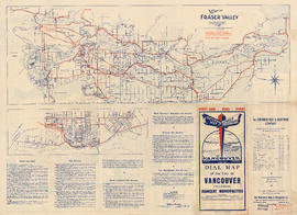
Map of Fraser Valley, British Columbia
Item is a map showing trunk roads, main and local roads, and railway lines.

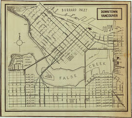
Map of Granville Street, downtown Vancouver
Item is a map showing Granville Street from the Granville Street Bridge over False Creek in the southwest to the train yard and waterfront below Cordova Street in the northeast. Numbered city blocks on either side of the street are depicted, with numbers and occupants' names (including businesses) shown for most of the properties. The location of the publisher's office on Seymour Street is shown.

Item is a map showing district lot, block, and lot numbers, and both current and former street names.

Map of south western British Columbia showing coastal lumber producers
Primary map shows lumber shippers and producers in the Lower Mainland and Vancouver Island. Inset maps show lumber shippers and producers in Greater Vancouver and the location of the primary map in relation to the rest of Canada.
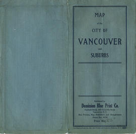
Map of the City of Vancouver and suburbs : map cover
![Part of D.L. [District Lot] 185](/uploads/r/null/d/0/2/d020a729408b2c6caa3fc78d706b687230bf429554ef426ba4dc104ce23d48d6/dbf9611e-8fed-4827-b82a-7e29f4922fc3-MAP904_142.jpg)
Part of D.L. [District Lot] 185
Item is section 4 of a City of Vancouver Surveys Branch sectional plan of Vancouver. Item shows area bounded by Nicola Street to Burrard Street and Nelson Street to False Creek.
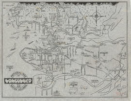
Pictorial map of Vancouver, British Columbia, city by the sea
Item is a pictorial map showing major roads and attractions in Vancouver, West Vancouver, North Vancouver, Burnaby, New Westminster, Sea Island and the northern portion of Lulu Island.

Item is a map showing wards, district lots, streetcar lines, railways, and names of businesses occupying waterfront sites on False Creek and Burrard Inlet.

Route map of Greater Vancouver and vicinity
Part is a map on recto of the brochure which shows major roads, parks and golf courses in West Vancouver, North Vancouver, Vancouver and Burnaby.

Sectional map : City of Vancouver, B.C. : Sheet no. S.V. 23
Item is sheet S.V. (South Vancouver) 23 of a City of Vancouver Surveys Branch sectional plan of Vancouver. Item shows area bounded by Vivian Street to Kerr Street and 45th Avenue to 54th Avenue.