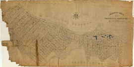
Contour plan of a portion of the City of Vancouver
- COV-S365-: MAP 715
- Item
- Aug. 26, 1889-1913
Part of City of Vancouver fonds
Item is a map of the area from Chilco Street to Raymur Avenue and Coal Harbour/Vancouver Harbour to False Creek showing topographic contour lines, streets, block numbers (in Roman numerals), sewers, manholes, and elevations at various points along streets.


![Area A-2 [Looking north-west. from 1000 Block Union Street]](/uploads/r/null/1/8/c/18c52e9c6ad49618ad4970e1d4e3577ab59b064154b43a899ad4a2e76673fbc7/741daa67-a4fa-4c43-9c8d-f215ae9de615-CVA181-32_142.jpg)
![[1908 Amoskeag self-propelled steamer with firefighters on street at No. 1 Firehall]](/uploads/r/null/1/3/5/13521aa9822ab0621dd174314ab0da79b3c9464050100ca355b44e2981514ca5/c293057e-0626-45c0-900a-16d6af894027-CVA354-038_142.jpg)
![[Deputy Chief C.W. Thompson at wheel of automobile in front of house, location unknown]](/uploads/r/null/0/7/9/079e0aa56e8021afe42cffa066588b8247abfa2d6241e7fa304e3bba3787c957/9464de60-42fe-4f1c-a30c-109c825dc061-CVA354-054_142.jpg)

![[Firefighters battling blaze at Passlin Hotel, 700 block Richards Street]](/uploads/r/null/5/6/4/5641b5fabc7f3acc6ed04ff5a4536e05e046766e1f840678824809879ab02ac7/4cadeaf9-8ebe-4b5b-97b1-6e7b9af8a59f-CVA354-262_142.jpg)


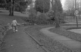

![Walks [2 of 3]](/uploads/r/null/1/e/1e83f91f6ef81f3820c37864fc9e84e53810be41cd4afe2e105d5e04254df8da/46a44585-1c9c-418e-8ae3-9e067cab679d-A64110_142.jpg)
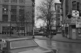
![Streets [2 of 139]](/uploads/r/null/6/9/691f5428eb0d996cc54bb5b3f09b24bf233cbf58710438a6fef12f18e55aaacd/753597c6-33be-41a0-a531-46cd27b9d2c6-A64143_142.jpg)
![Streets [7 of 139]](/uploads/r/null/4/6/46133e3d7b0e678679bd03b38d6235ff74fcde55411a6cb692d3ec33a9ebf924/8304b75f-82b9-4441-ad87-b1e39b4698d8-A64169_142.jpg)
![Streets [10 of 139]](/uploads/r/null/0/a/0ae4e35b96275ac70ee0c6fa3893aa168313f1be5c398df03112417ee3c58a0e/ea2e8b04-28c6-4c94-81e3-3f36e8b0a203-A64172_142.jpg)
![Streets [26 of 139]](/uploads/r/null/7/9/79170d39ecb86119b7f7c6ff61073159f531e9c9714e360c4031135e2a2d36c9/2de4f1c0-9fbc-4ef3-8bb7-d282ea347360-A64214_142.jpg)
![Streets [41 of 139]](/uploads/r/null/3/9/3927d98e7df929d4a9c48086401cce50129f1df5d06229ee78f4cea497e6d3fa/e2582502-f515-482e-a99c-0c69ef9ecf5f-A64229_142.jpg)
![Streets [55 of 139]](/uploads/r/null/4/4/449f33ab49aa27b49bf044a3bd2379a27aec3168da46d5801380256d1ebd8270/3c2c710f-af52-48b5-ab13-b64929987ab1-A64243_142.jpg)