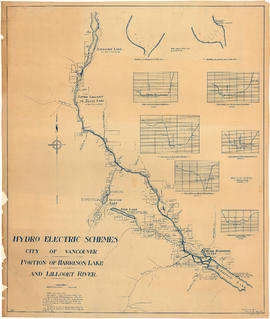
Item is a map sheet survey data from Lilloet Lake in the north to Harrison Lake in the south. The main map show potential dam sites, water levels, bridges and wagon roads. Significant bodies of water included on the map are Harrison Lake, Little Harrison Lake, Glacier Lake, Fire Lake, Lilloet lake, Little Lillooet or Tenas Lake, and Lillooet River. Also shown are Billy Goat Creek, 25 Mile Creek, Rogers Creek, Gowan Creek, Glacier Creek, Spriny Creek, Tipella Creek, Douglas Creek and 6 1/2 Mile Creek. The sheet includes two nautical charts showing depth soundings at the south end of Lillooet Lake and the south end of Tenas Lake. The six sections show depth measured along points on the Lillooet River.
![[Crews prepare speed boats for race on Harrison Lake]](/uploads/r/null/f/0/f08baf7d9877b7bf438545f5a91543b72c3a7cba767ad2d62a16b8951eedc668/1e7c93a3-0b27-4d55-a35a-709da4dcb1a1-A76051_142.jpg)


![Green Point Logging Co. Ltd. ["Shay" type locomotive at log dump]](/uploads/r/null/a/a/aa6aa96792c82f666bcbed914e4737e92faf11274a34680d3e73fabe547c94af/2a6df0f8-e695-44ae-8bf7-ce5dcec69a9b-A01327_142.jpg)
![Green Point Logging Co. Ltd. ["Climax" type locomotive #2 at camp]](/uploads/r/null/e/f/ef4e5aa00c7c2042872742560cc7df125ce826525eb3efa6178d6790c1066191/0f4447e0-ba09-44e8-8ea2-890746544aec-A01324_142.jpg)
![Green Point Logging Co. Ltd. [cutting area]](/uploads/r/null/5/f/5fd2878ed5184455177dc8f5af627465a790372610fc598ec36659f00195ad5d/463d7b65-1227-4f9a-9340-92b6709689d7-A01343_142.jpg)
![Green Point Logging Co. Ltd. [graded roadbed into cutting area]](/uploads/r/null/b/9/b94a962e7f7aadac283b7deef1b407821579c6db01554275e01e569746287282/0aee056b-9e4d-43f2-ba56-e51a1af752cb-A01342_142.jpg)
![Green Point Logging Co. Ltd. ["Jill-Poke" log unloading devise at log dump]](/uploads/r/null/0/9/092635e4a4564909490d7cee1ec10c25ac27e90b45b44a62682ea9b3be6df16a/92c6d73b-f5ca-4340-b469-74cb1b3e7bb8-A01330_142.jpg)
![Green Point Logging Co. Ltd. [log dump and camp]](/uploads/r/null/c/5/c57454864b763f0a3188bfae58e633e8a6fea63e3a4b9cf0089e4263e490e81b/1ef2ac24-5852-4fe5-9409-c911bbad4c65-A01325_142.jpg)
![Green Point Logging Co. Ltd. [logger at base of spar tree]](/uploads/r/null/9/b/9b225f58fc00706ff82c8bd22291c4e8fbf83212916bd0130a3ebcdfc64e136c/2c9f0030-16c4-40dc-9593-fb1873db6b08-A01340_142.jpg)
![Green Point Logging Co. Ltd. [rail line through cutting area]](/uploads/r/null/b/0/b0664eeffbe8fd91bc6647edc91c9a782da74ac61833970e2c426200619ce5a0/c415ff55-f8da-4ea6-a241-19a39c965033-A01344_142.jpg)
![Green Point Logging Co. Ltd. [rail speeder at camp]](/uploads/r/null/3/4/3481c446f90e6e4bcf3ff75637b14a361cb02dba2d32f1a6159586c750ef079a/f03126be-147e-4315-836a-7be9e6f5087f-A01334_142.jpg)
![Green Point Logging Co. Ltd. ["Shay" locomotive working at log dump]](/uploads/r/null/c/1/c10c5fd586a626342111fa959535ec6c2d8dad8fb05e2db5888fb176e80d300a/b04305ef-357e-491c-a1da-74b5497a22ff-A01331_142.jpg)
![Green Point Logging Co. Ltd. ["Shay" locomotive working at log dump]](/uploads/r/null/f/c/fc8e9ef0696f399c290c6ec8e911eeb700ae734f0742dfe7505b13e07fc46675/41ad5f27-0d3a-4334-a1de-c096b53bb30f-A01332_142.jpg)
![Green Point Logging Co. Ltd. [spar tree]](/uploads/r/null/9/8/98065b746003ab3d55d7b262827dcff33cd4f16b7b8dbee951241da981313943/907f9a3d-6a38-4da5-80bc-c33e4af4b787-A01341_142.jpg)
![Green Point Logging Co. Ltd. [Spar tree - log loading]](/uploads/r/null/1/b/1b1dbc7d6c67ac522e848cad32b52dd240cd66cc3f8e0fea1dfc81cd7687c714/6f9d7e7c-8379-48e1-8fda-07d0111d993d-A01338_142.jpg)
![Green Point Logging Co. Ltd. [Spar tree - log loading]](/uploads/r/null/3/f/3fae209f8fac516b86900107108db26ac0d741eae1b839bdbb366011c508302d/e8bc0507-d7fe-48b8-828e-832ba4cfd07d-A01337_142.jpg)
![Green Point Logging Co. Ltd. [Spar tree - log loading]](/uploads/r/null/8/8/8842cb457b8518bd3ec8480829fe4dd915e8202f09821f0170a8905a19466c2a/b4c3cd81-b368-4794-8f14-d16de4817fe5-A01339_142.jpg)
![Green Point Logging Co. Ltd. [steam donkey]](/uploads/r/null/6/e/6ec0d06f88e1fce957d0ec0c62b3b4072377691515ccf9d4944c5ef5971c8123/a5e8acbb-d566-436e-8638-ea6e3b8f6043-A01336_142.jpg)
![Green Point Logging Co. Ltd. [steam donkey]](/uploads/r/null/2/f/2facbd19ecfecaf08dee39860474a2c56d0b0bd5bb7ab46fb27853155bb32b42/b6ea0b0a-311b-4232-9a80-407818fde00c-A01335_142.jpg)
![Green Point Logging Co. Ltd. [train on trestle with sprinkler system]](/uploads/r/null/f/2/f2162b752eb9b747a1239e5a42333ce1ef8b3940960b7a1849df227477c0a20e/2cbda9f5-08be-42b2-ac45-804039c144e6-A01329_142.jpg)
![Green Point Logging Co. Ltd. [trestle with sprinkler system to reduce fire hazard]](/uploads/r/null/7/7/771f3bf5ae454191fd3da9ca62523e790754fcc29db03f13c7b42b1ee0f0f86e/4fe7b97e-69bf-4c71-9a41-4faa7a5a1c8d-A01328_142.jpg)
![Green Point Logging Co. Ltd. [two men sharpening axes]](/uploads/r/null/8/4/84916460c9bf470853b0d20539aa91aa0d9ece667df9f2bf3dff82c3cd7a7790/36803ef0-f9fc-4ae2-ba2a-90164448e8c7-A01333_142.jpg)
![Green Point Logging Co. Ltd. [view of lake and log dump]](/uploads/r/null/0/c/0c2b3b3d6e57f7c5a4c1c97dff4dc188c94746d595f37d6c0b3b73fe649ef36b/4a9116d1-89e1-4cce-8940-6faab43b05a8-A01326_142.jpg)


![[People exiting ferry wharf, Harrison Lake]](/uploads/r/null/9/d/9d19b05b5ac5810a1ede8d15506d3e583144a679cf0892fd210ec13e9e845f8a/e4ac131a-4a94-4de4-8083-045ae88421dc-A02849_142.jpg)


![[Spectators on dock watching speed boat racing on Harrison Lake]](/uploads/r/null/d/4/d4b8b4e7b65c8a5dce2f416d00b7aa22776f89c4d514aedff0f4966c79b9296a/32160eb3-4556-46eb-8db4-bcc17200c1bd-A76054_142.jpg)
![[Speed boat racing on Harrison Lake]](/uploads/r/null/5/1/51432587aac126b24f3f38ff092d3fac0ab7ea45bc3fb2d4aace89e5bab63d97/165b51a9-1fbe-4f07-beae-5b73260d8df9-A76053_142.jpg)
![[Speed boats along the Harrison Lake Transport Company boats for hire dock]](/uploads/r/null/1/4/143ffad430c72e509c12128443859e86d0f691b0bfb7e88982c821abefee7fce/4f7285fd-e457-4058-9574-afec46cd2f90-A76050_142.jpg)
![[Speed boats racing on Harrison Lake]](/uploads/r/null/c/1/c1e87a66ed5efe3c279260c66bf909b02a1b54df595bd7d5e2f35287c4e6649b/30088c46-4c23-4a8e-a5e7-95487829c303-A76052_142.jpg)


