
Wildlife : Hurricane Ridge, olympic marmot
- AM1502-S1-2-: CVA 1502-2036
- Item
- [July 27, 1992]
126 results with digital objects Show results with digital objects
Wildlife : Hurricane Ridge, olympic marmot
![Orthocarpus imbricatus : owl's clover [at] Hurricane Ridge](/uploads/r/null/2/3/23d6ad2373cdf9b28420acef1c262e781de9e62098aa8ac5edc6160421f07ce5/21890175-83db-46ce-83f3-bdc27c9a7246-A56773_142.jpg)
Orthocarpus imbricatus : owl's clover [at] Hurricane Ridge

Wildlife : Blue Grouse Hurricane Ridge

Wildlife : Hurricane Ridge, olympic marmot

Wildlife : Hurricane Ridge, Olympic Marmot

![Veratrum [at] Mount Baker, Washington](/uploads/r/null/9/c/9c38d8792e2c86902dfa539e3525cd77be414e011c9d1cb0f371b8c9955f3f75/086b1136-c8a9-4d27-abb1-601c25f41ce1-A58335_142.jpg)
Veratrum [at] Mount Baker, Washington
![Vaccinium [at] Mount Baker, Washington](/uploads/r/null/3/3/338e12c80bcf0050cb72f9fee4dcc07a6d63e1e11fe4ae1e46a591e9f9700888/539c7e4f-1a83-4682-930e-c61019972a0b-A58319_142.jpg)
Vaccinium [at] Mount Baker, Washington
![Veratrum [at] Mount Baker, Washington](/uploads/r/null/8/0/80c95d684d66b84d35f9ff795d098fae90d542e9efd215455c701df685169c6d/051712fc-6b92-478a-a2e6-ece0f2ecf2ba-A58334_142.jpg)
Veratrum [at] Mount Baker, Washington
![Leutkea pectinata [at] Mount Baker, Washington](/uploads/r/null/a/5/a5f8a6e5bb8edbdef585415bc1740855a77d3fd59747a072826ea4a478102eb2/f50f9cfa-8de1-4116-aa45-09f812c82a5f-A56376_142.jpg)
Leutkea pectinata [at] Mount Baker, Washington
![Paeonia suffruticosa [at] US Nat[ional] Arboretum](/uploads/r/null/3/6/3606ad94689fed4f1740c5d2c87ba8439a9e306af33a0c6504995c8199f0bcb9/fc80ad8b-5e31-4462-b96b-2eafc2bc0f2f-A57154_142.jpg)
Paeonia suffruticosa [at] US Nat[ional] Arboretum

Landscape - general : Mt. Rainier

Landscape - general : basalt columns (central Washington)
![Phyllodoce empetriformis, Hurricane Ridge - Olympic Pen[insula]](/uploads/r/null/e/2/e2214854c50ece5526d274af6b748ec02f81df8f96d535fc5831ecd0e298f7ce/c231e151-61e8-4dfb-b2e4-4f15c426fce0-A57201_142.jpg)
Phyllodoce empetriformis, Hurricane Ridge - Olympic Pen[insula]

Part of City of Vancouver Archives sound recording and moving image collection
Item is a film showing group golfing, Stanley Park including Siwash Rock and Girl in a Wetsuit statue, a trip to Atlantic City including footage of Shriners band practice at a hotel, a man dressed in a bikini, a parade and men getting shoes shined, views of New York City from inside a vehicle and Expo Spokane grounds.


South western British Columbia
Item is a map of southwestern British Columbia and northwestern Washington showing cities, municipalities, and settlements, post offices, government agents, railways, roads, ferry and steamship routes, air and seaplane ports, parks, campsites, glaciers, customs ports of entry, and elevations of mountains. Inset maps show the islands north of Cape Scott and the Seattle region. An small key map shows the primary map's location in relation to the rest of British Columbia and other maps published in the same series.
![[Lake Terrell in Whatcom County]](/uploads/r/null/2/2/2223e2313d4eb14277ea1f4ce3a6deab7ce88c988a6a741e894d461b467c2d2b/1e783d26-377f-4cfa-9940-0c8a79154760-A33354_142.jpg)
[Lake Terrell in Whatcom County]
Part of Major Matthews collection
![[Lake Terrell in Whatcom County]](/uploads/r/null/f/e/fe72f9dbaa7426884cb9ce7f067de3d81742514a33fa456f973f887839188f26/df077ebb-9776-4b4b-9711-8883a251c90a-A33355_142.jpg)
[Lake Terrell in Whatcom County]
Part of Major Matthews collection
![[The entrance to Fairhaven Park]](/uploads/r/null/d/1/d1bce377719fe72a83156fee9aea583aace0164cc961d110e6a8551a35571d1a/9c2c756b-94f8-4b17-9397-2c86e0a87287-A26812_142.jpg)
[The entrance to Fairhaven Park]
Part of Major Matthews collection

Part of William Orson Banfield fonds
![Lower face [of Grand Coulee Dam]](/uploads/r/null/9/c/a/9ca4a3394db580ec0a046099dc5cc5aab4af92a1d5c570a0882f4bfe501f49d8/e8ca452f-e656-4672-9e0e-15c5c05bd9eb-CVA289-005_142.jpg)
Lower face [of Grand Coulee Dam]
Part of William Orson Banfield fonds
![Distant view [of Grand Coulee Dam]](/uploads/r/null/c/9/6/c96305b71bf4f3b9fb1a0e8554c8ce50b1ab4a92e03dd91faab096f6aa29982b/f72c131d-cf00-4f0b-984d-33783d353b9e-CVA289-005_142.jpg)
Distant view [of Grand Coulee Dam]
Part of William Orson Banfield fonds

The start of the lake behind the dam
Part of William Orson Banfield fonds
Part of William Orson Banfield fonds
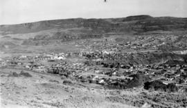
![Oroville, Wash[ington] from Anarchist M[oun]t[ain]](/uploads/r/null/c/6/c/c6cbb9de05dfd059413bfe53f740e3b92cbd2c230b73741ec481cea5e1e9694e/8de554c5-6470-4bc5-bb0a-675aef0b0760-CVA289-005_142.jpg)
Oroville, Wash[ington] from Anarchist M[oun]t[ain]
Part of William Orson Banfield fonds
![[View of Mount Shuksan from the road to Mount Baker]](/uploads/r/null/d/7/d77b6396eecb2d0f09fe1df0a14704f25d6a92df9eb23bf1fc9adae7a87adaa0/b0cecf3c-95b9-48e0-81cf-a5524cdb66dc-A32833_142.jpg)
[View of Mount Shuksan from the road to Mount Baker]
Part of Major Matthews collection
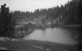
Twin Lakes from Mt Winchester, Mt Baker National Forest
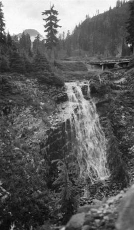
Galena Falls - Mt Baker National Forest

Galena Creek, Mt Baker National Forest Reserve

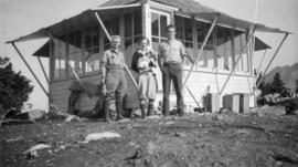
Forestry Lookout, Mt Winchester, Mt Baker National Forest Reserve, Washington
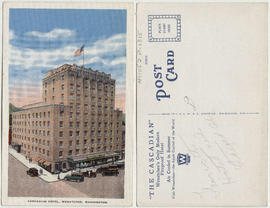
Cascadian Hotel, Wenatchee, Washington

Pentagonal columnar lava near Bogley Lakes, Mt Baker National Forest Reserve, Washington

Pentagonal columnar lava near Bogley Lakes - Mt Baker National Forest Reserve, Washington

Mt Shuksan from Kulshan Ridge, Mt Baker National Forest Reserve

Mt Baker - Shots of Washington, Mt Baker National Forest Reserve

Part of City of Vancouver Archives technical and cartographic drawing collection
Item is a sheet with 4 maps on recto and text on verso. The maps depict southwestern British Columbia; the information on the verso is predominantly statistics re: the province's economic development and tourism information for various towns and districts in the area.
![M[oun]t Shuskan from Table M[ountain]](/uploads/r/null/0/3/4/0340750cdde3066bad0daffa38e79a47c10aeb20b2d1b0163c56e34c6cbebf70/dd7007b8-b938-4f3d-9d45-fcbe89141044-CVA289-004_142.jpg)
M[oun]t Shuskan from Table M[ountain]
Part of William Orson Banfield fonds
Item is a photograph showing Mount Shuskan with Beatrice Timmins in the foreground.
Item contains a commercial and visitors map of the southwestern land districts of British Columbia on one side and textual information on the region on the other.
![[Beatrice Timmins] on Table M[oun]t[ain]](/uploads/r/null/8/2/d/82db37d9b9fd4aa595e394f944fb6be13512bd87a45ea351d393bede0d1c09f8/86c64f1b-4533-4a75-a529-21b3846d5c03-CVA289-004_142.jpg)
[Beatrice Timmins] on Table M[oun]t[ain]
Part of William Orson Banfield fonds

The Sunrise Lake at Table Mountain
Part of William Orson Banfield fonds
![Table M[oun]t[ain]](/uploads/r/null/9/3/f/93f45b7e77f91c47f5825d46db7a4f7a92ca8db083def523a6c7b348e94d30c5/1125e985-3495-40fc-81b4-81f89ec4fe25-CVA289-004_142.jpg)
Part of William Orson Banfield fonds

Part of William Orson Banfield fonds
![The road at summit [of] Blewet Pass](/uploads/r/null/8/7/a/87af9a01f91e6a639af597d399c2e04b941e6bb36f49e35531f96a2c196a342f/6eb5986e-f3e3-4be3-8663-3b8cfd485586-CVA289-004_142.jpg)
The road at summit [of] Blewet Pass
Part of William Orson Banfield fonds
![[Columbia Gorge Hotel] and garden](/uploads/r/null/e/e/2/ee2003be0ffaf1d109c4a8fc42712c58d3411c739f7509ef851cd46f055fb8f2/f39d9893-f052-4b8e-a999-d012268b5c59-CVA289-004_142.jpg)
[Columbia Gorge Hotel] and garden
Part of William Orson Banfield fonds
![Cloud Cap Inn, M[oun]t Hood](/uploads/r/null/c/3/1/c312ea1285c10b4806d007ac20223e4d5e45ff822506f5a5913446df5899e1bc/bb39cd62-e9bf-449a-b9bc-4050c2712672-CVA289-004_142.jpg)
Part of William Orson Banfield fonds
![M[oun]t Hood](/uploads/r/null/f/f/a/ffa40e15d75e58107cf469529306b57965f1d07e8852c92312aa0e657790e20d/f2d5e63d-7a89-4e1d-a7ba-7d56f8254194-CVA289-004_142.jpg)
Part of William Orson Banfield fonds

Part of William Orson Banfield fonds